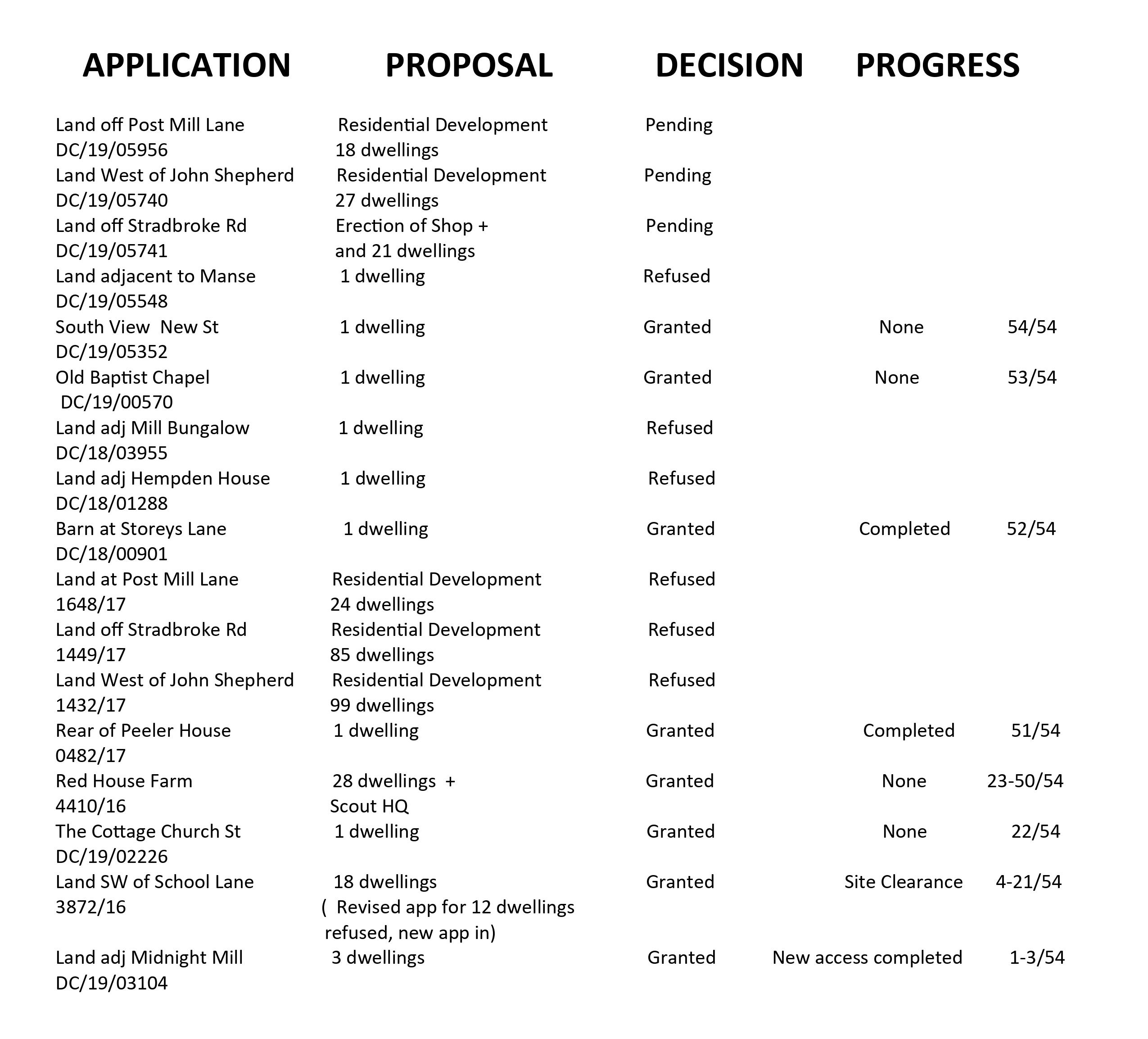
From: John and Pam Castro Sent: 30 June 2026 18:22 To: Philip Isbell Cc: Eliana Ciufo Subject: Red House Farm Fressingfield . 4410/16. EN/25/00438
Dear Philip,
Apologies for writing to you, but we seem unable to make any progress on the issues at Red House Farm.
There has been on going correspondence over the last 9 months over the failure of the developer of the above site to adhere to the conditions attached to the above application. We did alert Enforcement to the shortcomings when we first became aware of them.
We appreciate that the original developer went into liquidation and work on site stopped some months ago which, understandably complicates any action Enforcement may wish to take.
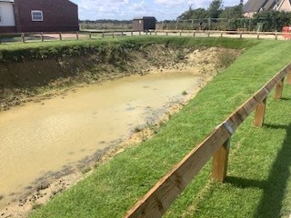
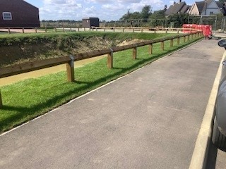
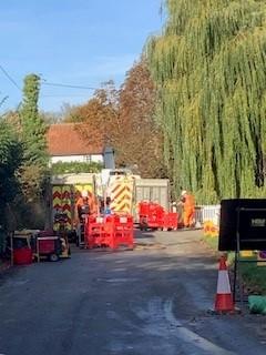
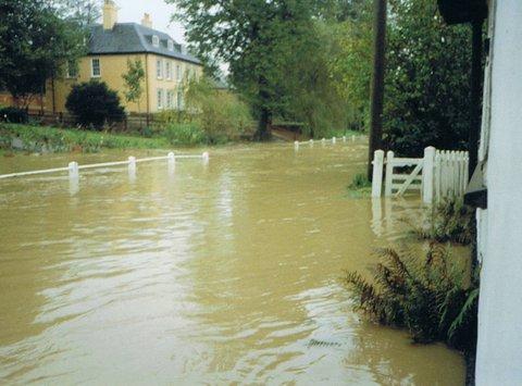
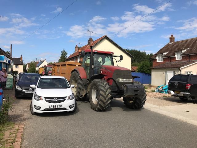
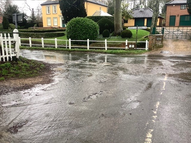
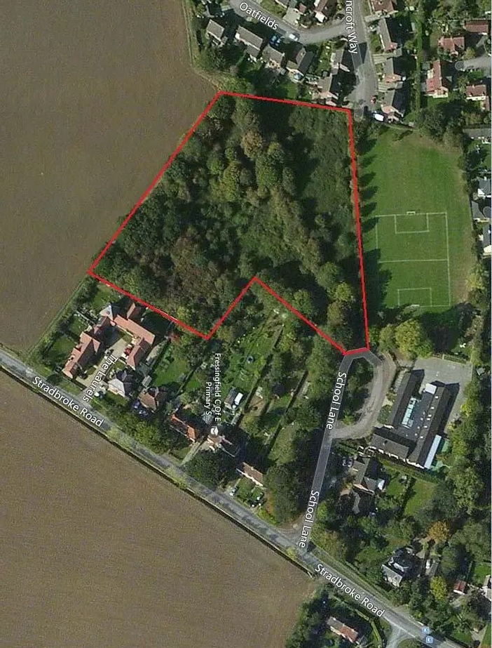
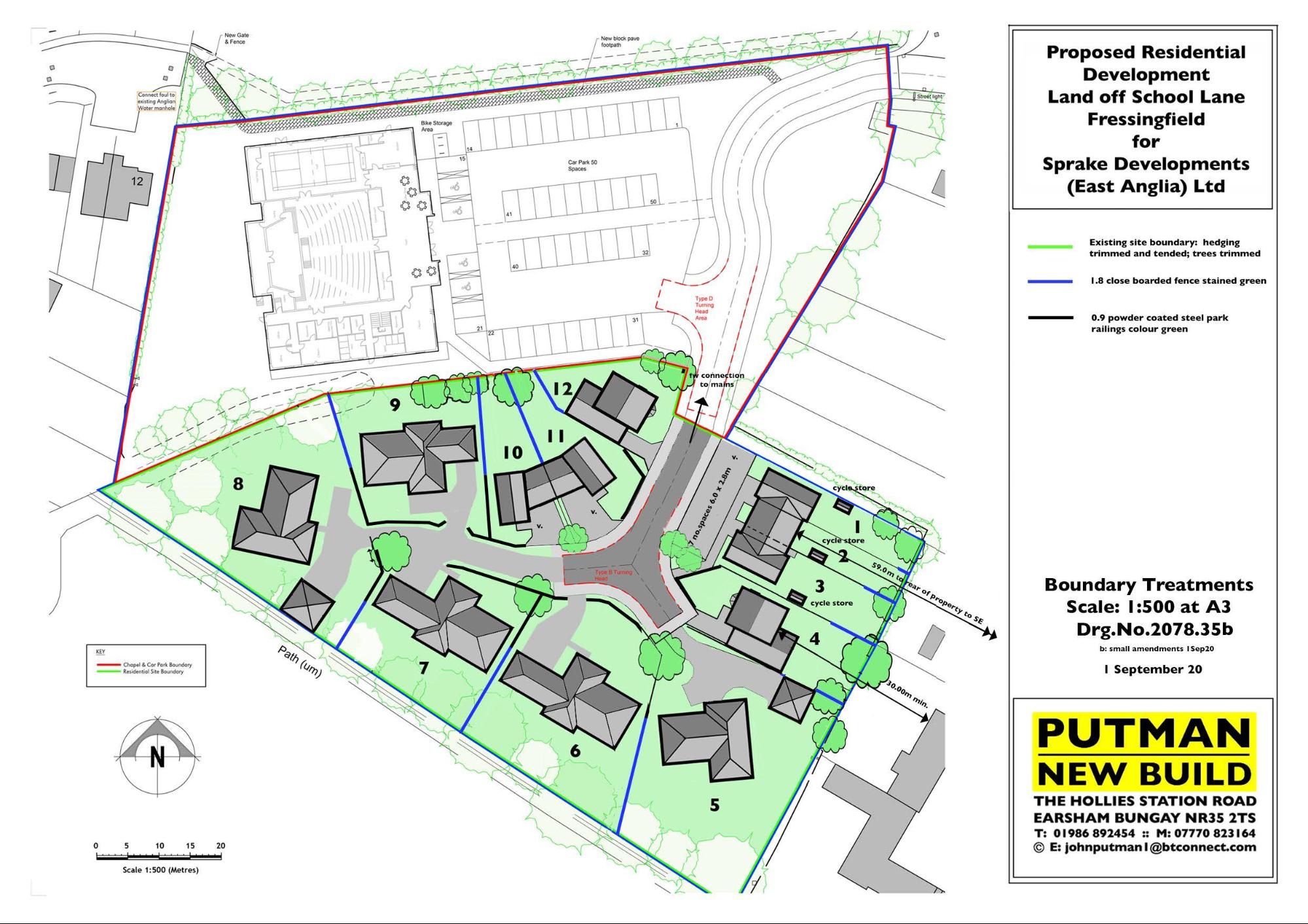
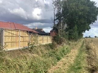
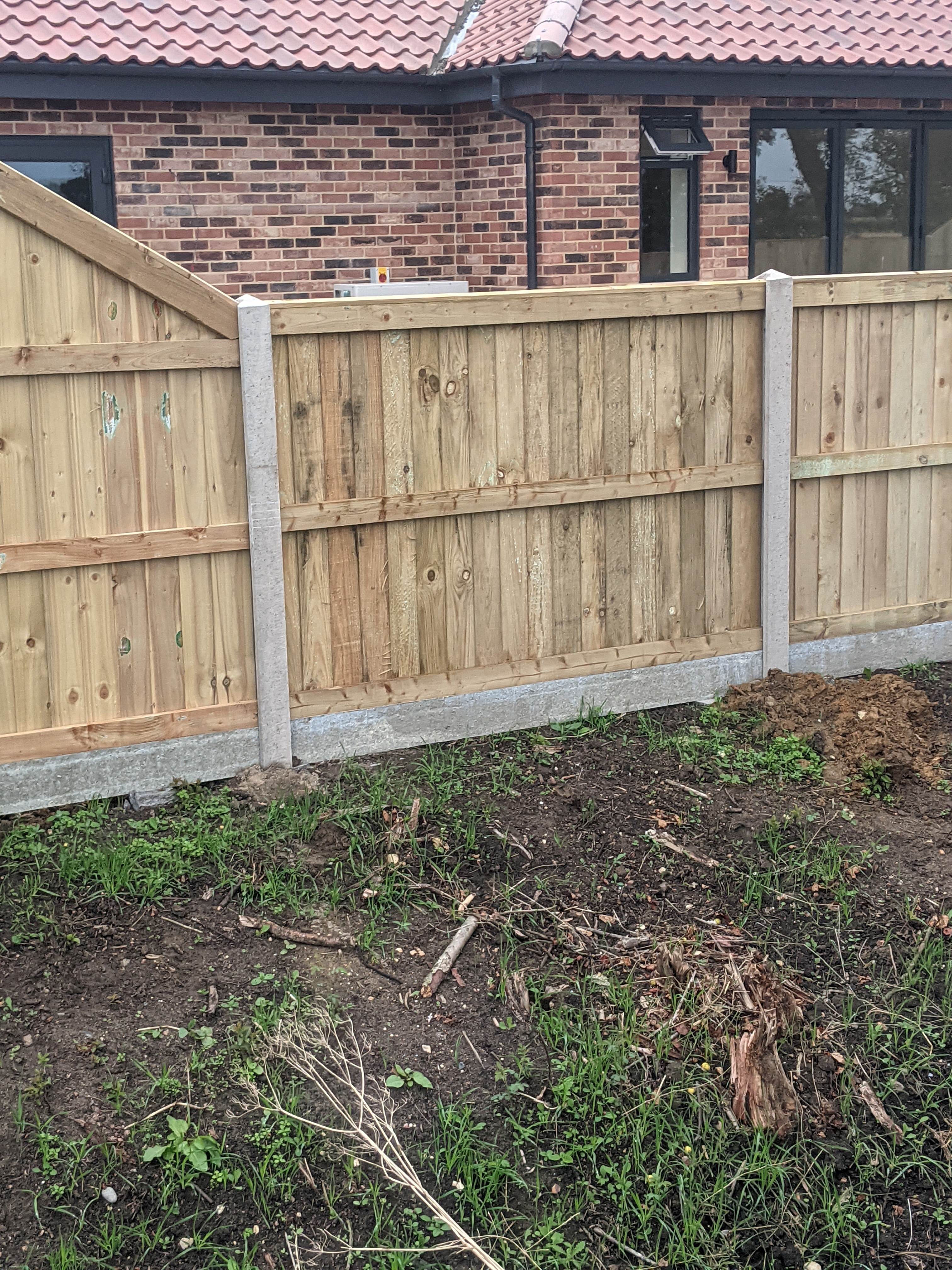
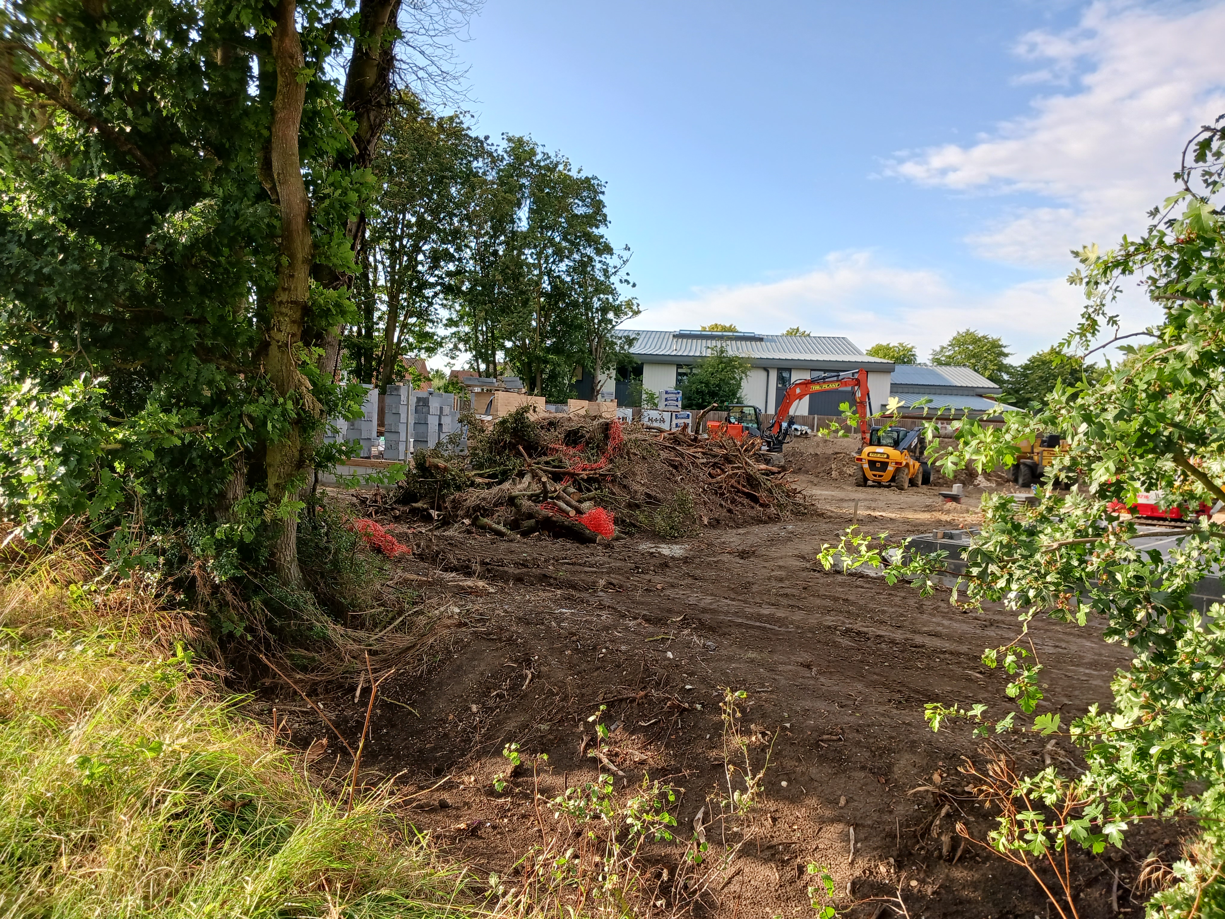
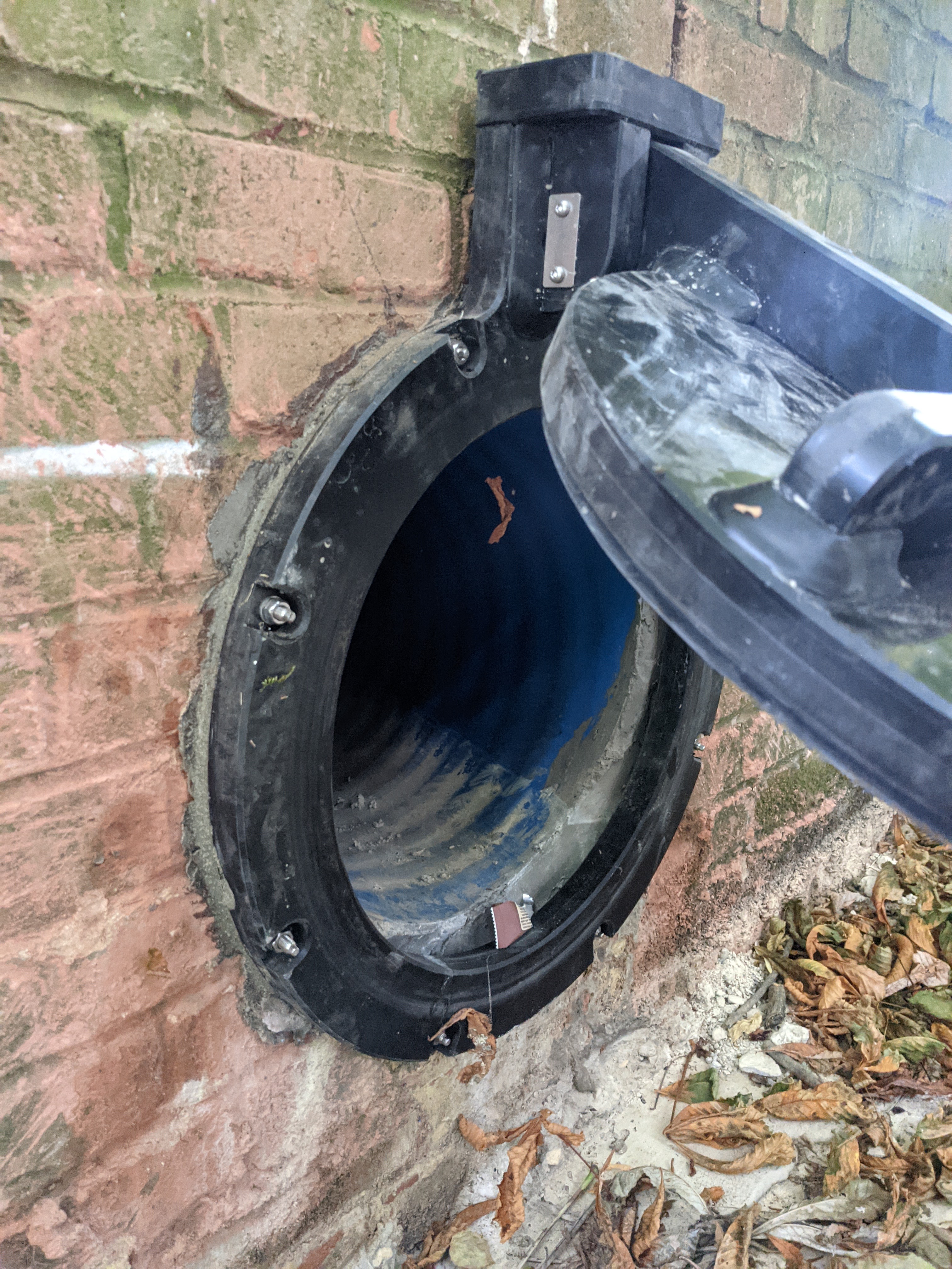
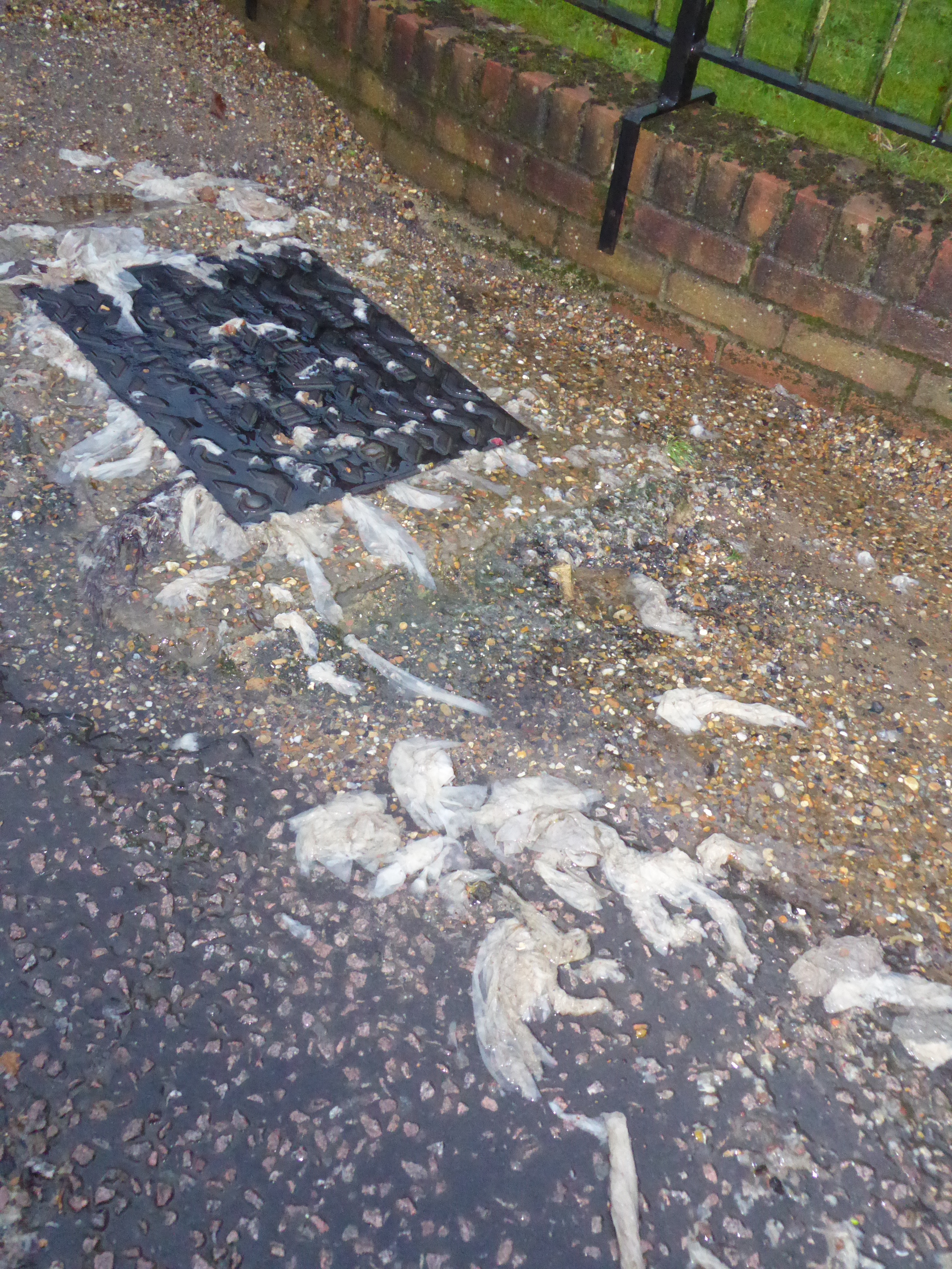
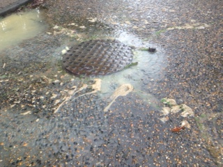
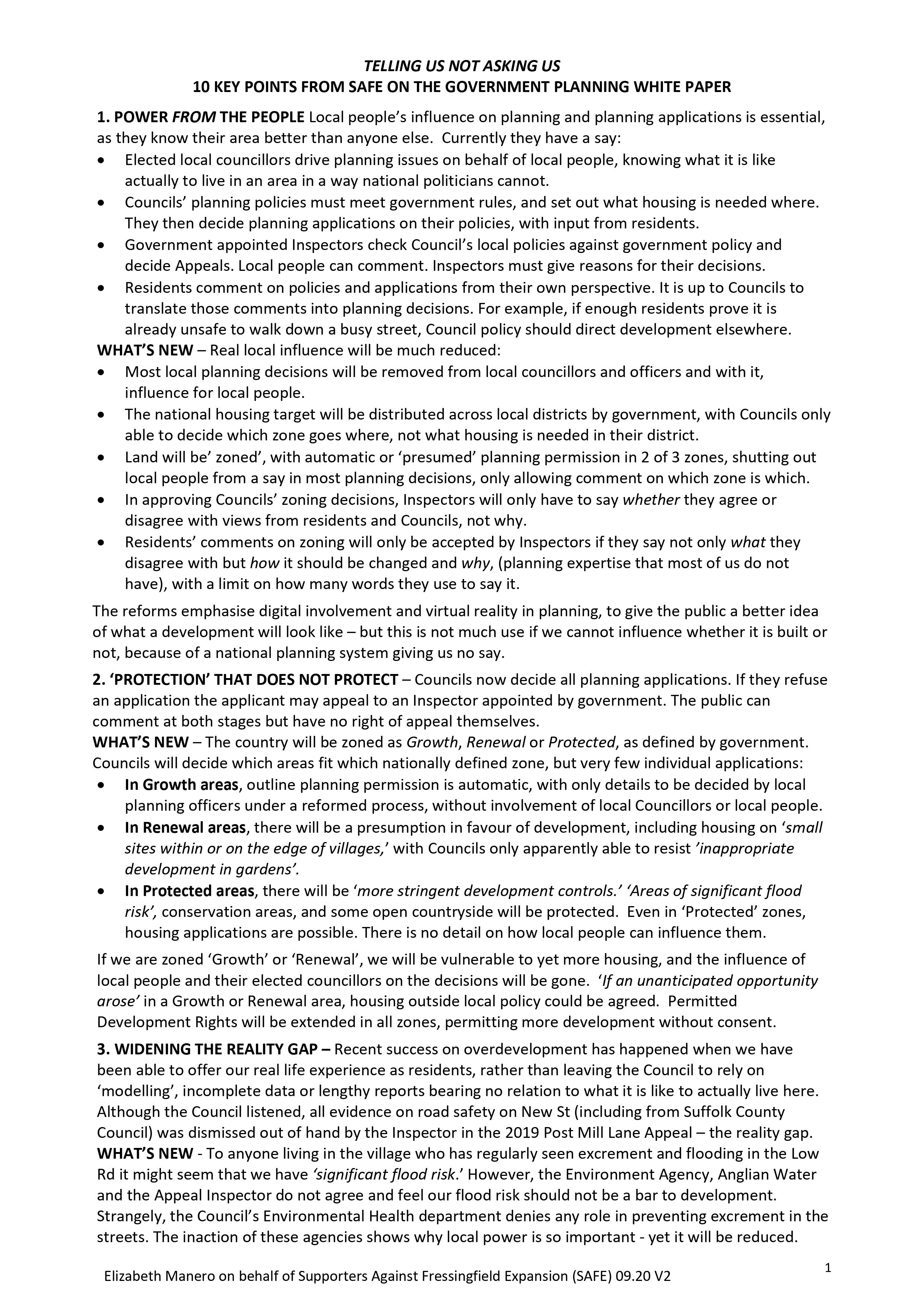
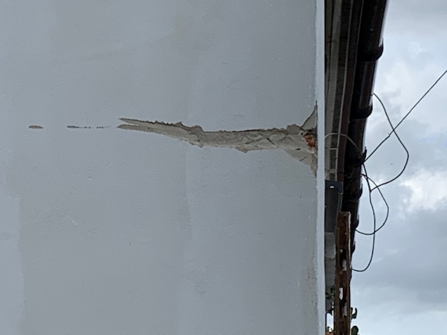
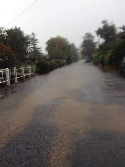
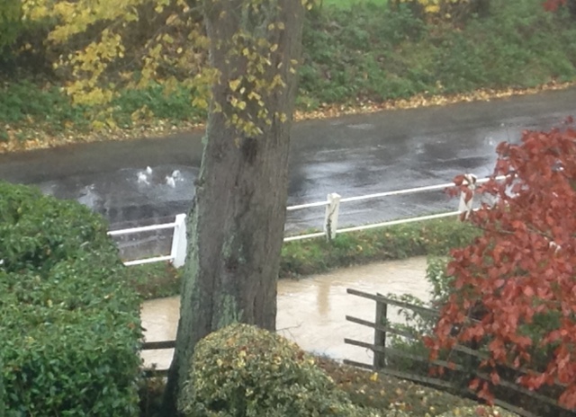
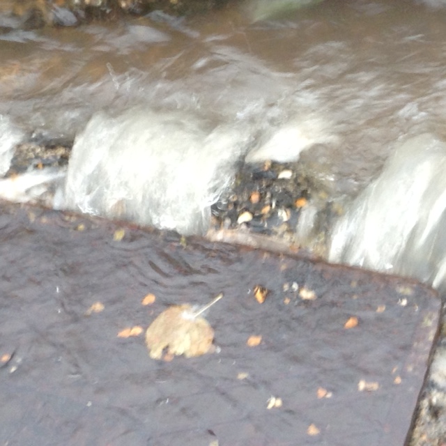
Before the works stared on site there was a dense mature hedge on the site boundary abutting the road. This was removed in order to facilitate a pavement. The approved soft landscape drawing clearly shows on the boundary facing the road the provision of a replacement new hedge of native species together with 5 “advanced nursery stock trees”. We attach the relevant drawing for ease of reference. We also attach two photographs as to what has been built, bearing no relationship to the approval.
There is rumour ( pure speculation) that the site has been sold , we are therefore raising the issue again as it is important that any new purchaser is aware of the obligations to complete the project according to the approved plan.
There are a number of problems with what has been built-
The sides of the drainage ditch are much steeper than shown on the approvals. If one to fall in it would be difficult to get out without assistance.
The low level wooden single rail fence affords little protection for small children and animals.
Cars could easily crash through the small fence and end up in the drainage pond.
Aesthetically this is very unattractive.
Residents did not complain at having lost a mature hedge as they were assured there would be an appropriate replacement hedge with semi mature trees.
We would be very grateful if we could receive information as to the current state of play and an assurance that the treatment of the northern boundary will be consistent with the approval and that any new purchaser will be made aware of the need to complete the works as approved by yourselves.
Very many thanks.
Kind regards
John and Pam (Castro)
New Towns in England
The Government is undertaking an open public consultation on the New Towns Draft Programme which was published in March 2026.
Seven locations have been proposed, with others in reserve. It is suggested that these new towns would provide hundreds of thousands of new homes with associated economic benefit for England.
Depending on the outcome of the formal consultation the proposed new towns are:-
Tempsford
Crews Hill and Chase Park, Enfield
Leeds South Bank
Manchester Victoria North
Thamesmead, Greenwich
Brabazon and West Innovation Arc, South Gloucestershire
Milton Keynes
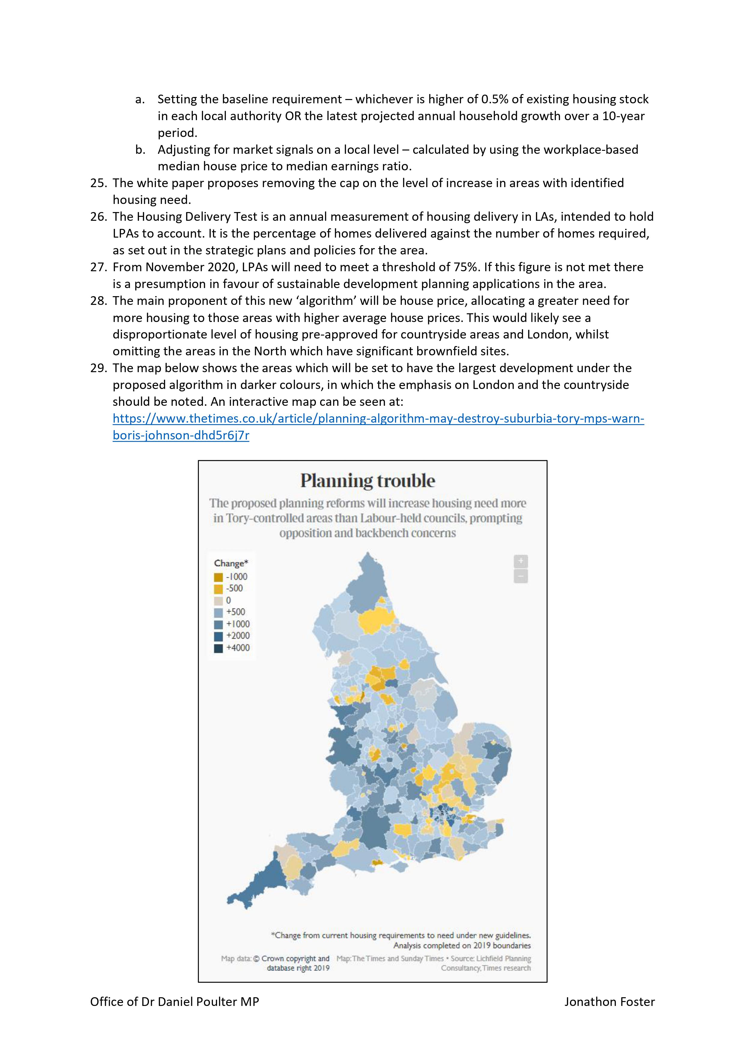
At least 3 towns will commence during the current Parliament. The list confirms that that the new towns will be spread across England and each will provide at the very least 10,000 new homes, often with the ability to expand further. A new town will provide both social infrastructure and affordable housing in a way that is not possible with smaller sites.
It is intended that the housing will be well designed in attractive places and with good connections. There will be adequate infrastructure, good services and amenities.
All of the preamble regarding the new towns is to be commended, but how does it equate to the need to build in Fressingfield ( and similar villages) where we have very inadequate infrastructure? This is exemplified by inadequate sewerage, no public transport, lack of footways, and narrow dangerous roads. More building will make things worse and destroy the rural environment where some want to live.
The requirements for building in a New Town is de facto an admission that Fressingfield is not suitable for further development.
John Castro 5.4.26
COMMENTS ON THE DRAFT NEIGHBOURHOOD PLANmade by SAFE members and associates.
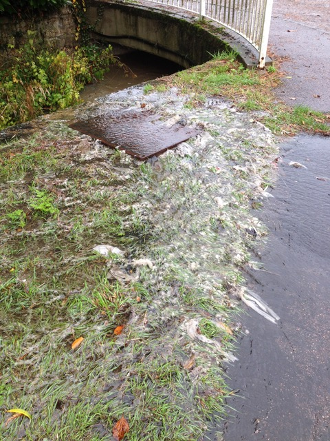
On 17 December 2025 we had an informative meeting with two senior engineers from Anglian Water arranged by the CEO’s office to discuss the long standing problem of sewage overflow in the village. The last episode was on 14 Nov.2025 and despite a tanker being used to remove 7 loads of fluid from the pumping area in Harleston Hill there was still sewage egress in Low Road. In future when heavy rain is forecast 2 tankers will be in attendance This manoeuvre is designed to reduce the volume & frequency of overflow BUT it is not a long term cure. .
The cause is surface water ingress entering the closed foul only system. Despite extensive investigations all of the entry points cannot be identified. A spring, water running along the outside of pipes , illegal roof connexions are some identified reasons for water being in the wrong place .There may be other reasons BUT Anglian Water stated that it cannot be totally cured and the aim is to reduce the frequency of overflow. To this end multi- disciplinary teams of workers from Anglian Water, Highways, the Inland Water Board, Environment Agency & others will cooperate.
Other suggested cures for the problem have been considered & dismissed such as screwing down sewer covers, re-lining the pipes, increasing pump speed, increasing pipe diameter. At present there is no absolute solution.
The sewerage has a finite volume which if exceeded will overflow. Changing the positions of connexion to the system will have no effect.
More buildings will increase the likelihood of more overflows. In each new house there will be an average of 2.5 people per house each producing 145 litres of foul water per day. If this enters a system that is already full it will cause more overflows, more frequently .
Having considered all of the evidence Anglian Water have acknowledged that sewage egress in Fressingfield is a real problem which can be improved but cannot be completely cured.
John and Pam Castro
18.12.25
Former Neighbourhood Plan Steering Group Chairman Gives reasons for his Resignation
In public and political life it is not uncommon for Resignation Letters to be published. At the beginning of November John Kelsall resigned from his position as Chair to the Steering Group of the Revised Neighbourhood Development Plan ( NDP). His resignation letter has not been published nor his reasons for taking this action, although they are of interest to the village, particularly as he is the second person to resign as Chair. John has given permission to publish a modified version of his letter. It is abridged because it refers to matters which are still regarded as confidential. The whole process has been secretive despite the Parish Council stating that the review would be “open and transparent every step of the way.”
Mr Kelsall resigned because he was not happy with the revised draft plan . Official documents indicate that additional affordable housing is not necessary and the reasons for this were succinctly argued. The draft NDP refers to “ demand identified in estimates” with no explanation as to where these “estimates” have come from. Associated with any increased affordable housing would be significant market housing. A lobbying paper sent to Mr. Kelsall which agreed with National Policy on the location of affordable housing was presented by him on behalf of a resident was greeted with derision by some of the steering Group members. Other comments on affordability and suitability of housing in Fressingfield were confusing.
The comments on the frequency of sewage egress were inaccurate and statements on the relationship between new build surface water and additional sewage are inaccurate. Pictures of sewage sent by him appear to have been omitted.
The final paragraph of Mr. Kelsall’s resignation letter states –
“I do not think this document will serve the people of Fressingfield as well as it should. I have felt I was fighting an uphill battle to get my views across,views which coincide with those of many Fressingfield residents. I feel that the Parish Council has its own agenda with which I am at odds. There seems to be little point in my carrying on and as there is only one meeting left plus the consultations where I could not, in all honesty, support significant parts of your proposals I have no option other than to resign as Chairman of the group.”
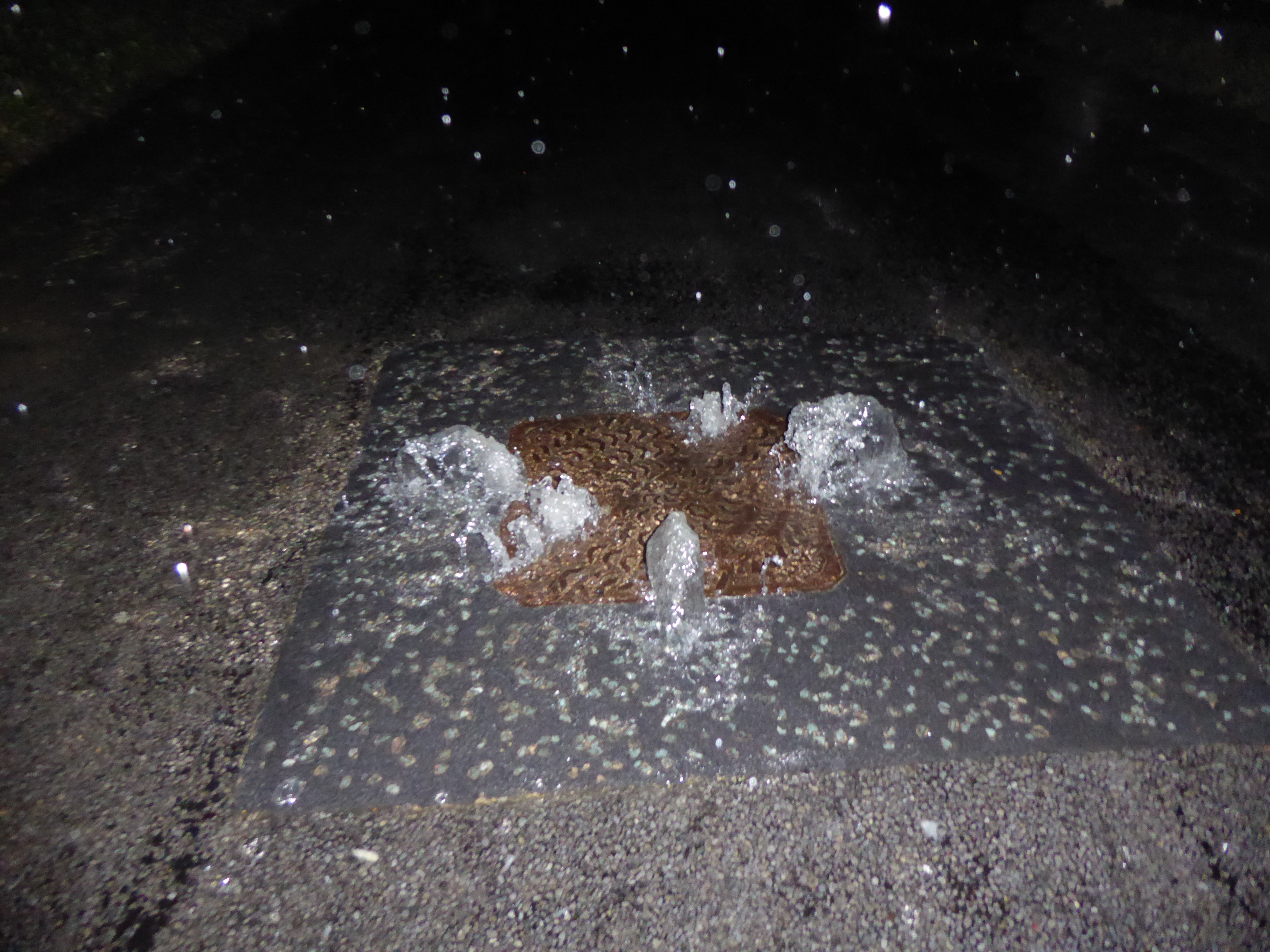
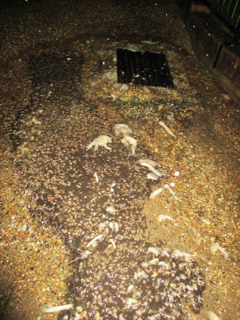
Sewage overflow in Fressingfield despite Anglian Water efforts to prevent this.
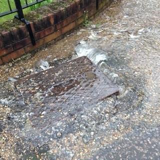
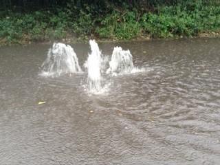
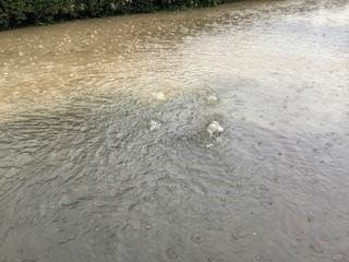
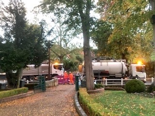
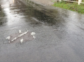
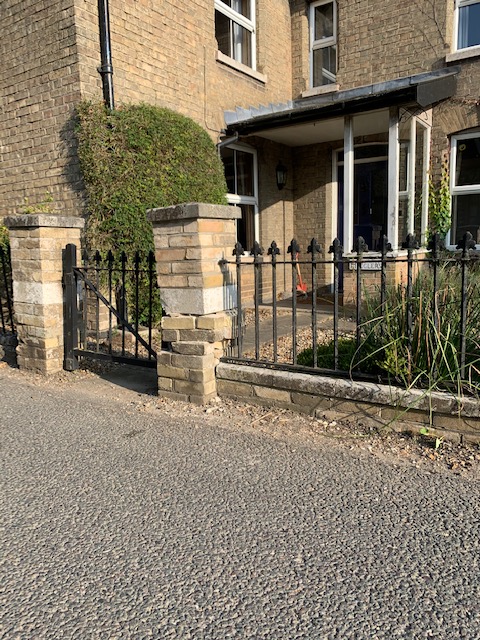
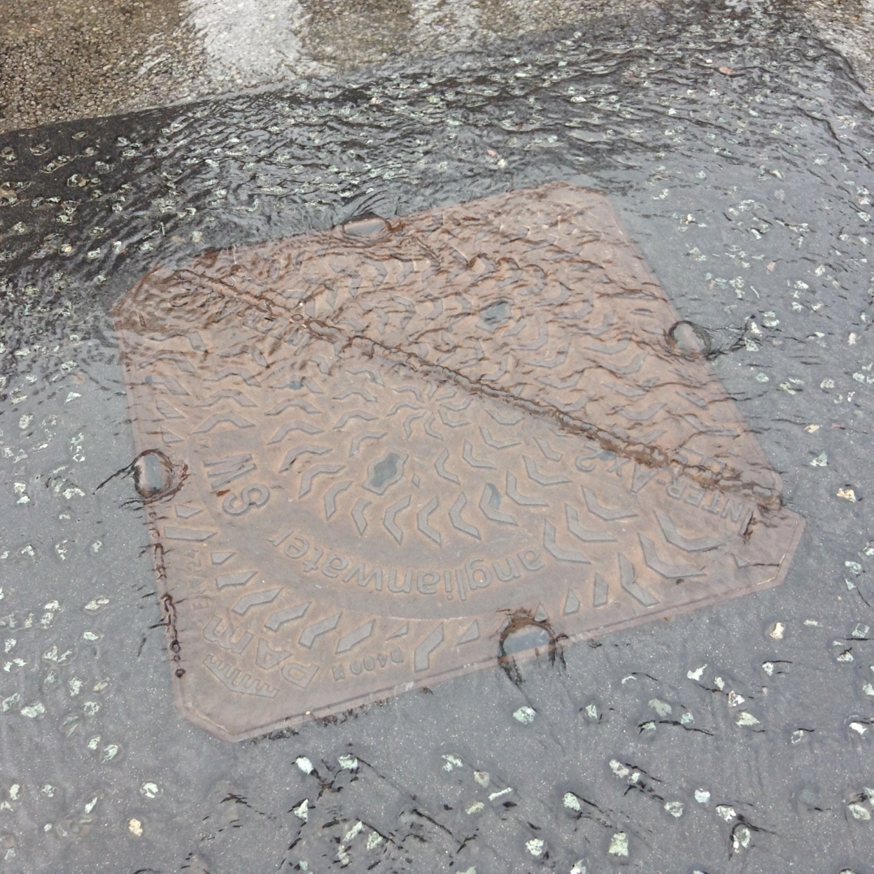
On 14 November 2025 there was continuous leakage of sewage , with visible toilet paper from 2 manholes in Cratfield Road.
This was first noticed at 1.30pm , but had obviously commenced well before this time, and was still occurring at nightfall. ( photographs are below).
It has been reported both to Anglian Water and the Environment Agency. This is the 23rd event since records have been made and the 8th since the major works were undertaken by Anglian Water in October 2022.
A large Anglian Water tanker was first noted at 7 am on 14th November at the pumping station and was present all day continuously removing foul water from the sewerage to the treatment centre in an attempt to reduce egress of sewage. SEVEN tanker loads were removed. The process was obviously unsuccessful despite continuous efforts.
This demonstrates that Anglian Water recognise that there is a problem with the capacity of the sewerage.
JEC\PEC 14.11.25
Subsequently on 16th November Anglian Water sent a team to check that the pump had been working correctly and they confirmed that everything was in order. The pump performance is monitored centrally. In Fressingfield many of the manholes are fitted with sensors which measure the pressure and the volume of the fluid within them. These are also monitored centrally. Evidently in high risk areas tankers are on standby when heavy rain is forecast.
Subsequently I received an email from the CEO s office at Anglian Water as follows:- “I have received confirmation as expected this issue was caused due to heavy rainfall conditions causing the site to be hydraulically overloaded.The pumping station was checked, and the operation of the pumps were working as expected, they just couldn’t keep up with the incoming flows.” “As you are aware, the team deployed a tanker on site to reduce the loading and flooding to the pumping station.” Sally Cooper Executive Assistant to Mark Thurston ,CEO Anglian Water Services Ltd. 21.11.25
MORE SEWAGE There were no further sewage episodes egress between 14th November and 22nd November. On 22nd November at 6.30pm a significant overflow from the sewer was noted and a video was taken.
At some point during the night the overflow stopped. The next morning there was significant toilet debris on some drain covers.
More housing will generate more foul water which will enter the sewerage and take up space. This means there is less capacity for surface, rain and other water. Therefore, the threshold for flooding will be lower, resulting in more frequent flooding and lasting for longer periods.
This means more sewage will be spread, more often onto roadways, in the Beck and on pavements and gardens. JEC 23.11.25
Chair of NDP Review Group Resigns
Mr. John Kelsall has resigned from his position as Chair of the Steering Group of the N D P ( Neighbourhood Development Plan) review.
He is the second chair of this committee to resign during this process. The first having resigned last March.
The reasons for the Chair’s departure and his resignation letter are not yet in the public domain.
SAFE remains critical of the process because of its secretive nature and the minimal involvement of villagers, particularly as the Parish Council Chair had stated that there would be “ openness and transparency every step of the way.”
J.C.
11.11.25
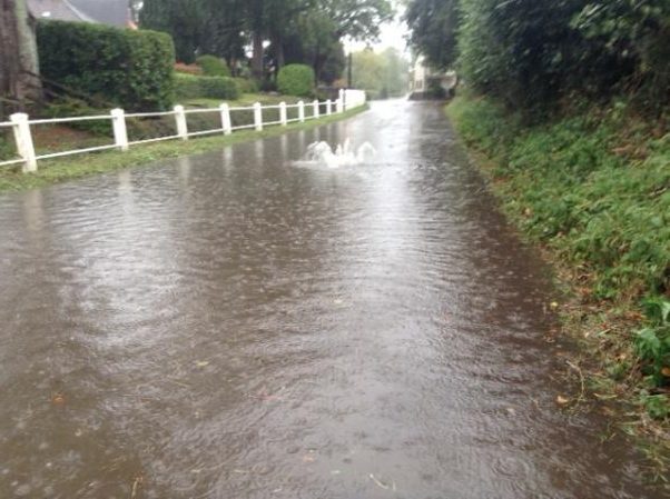
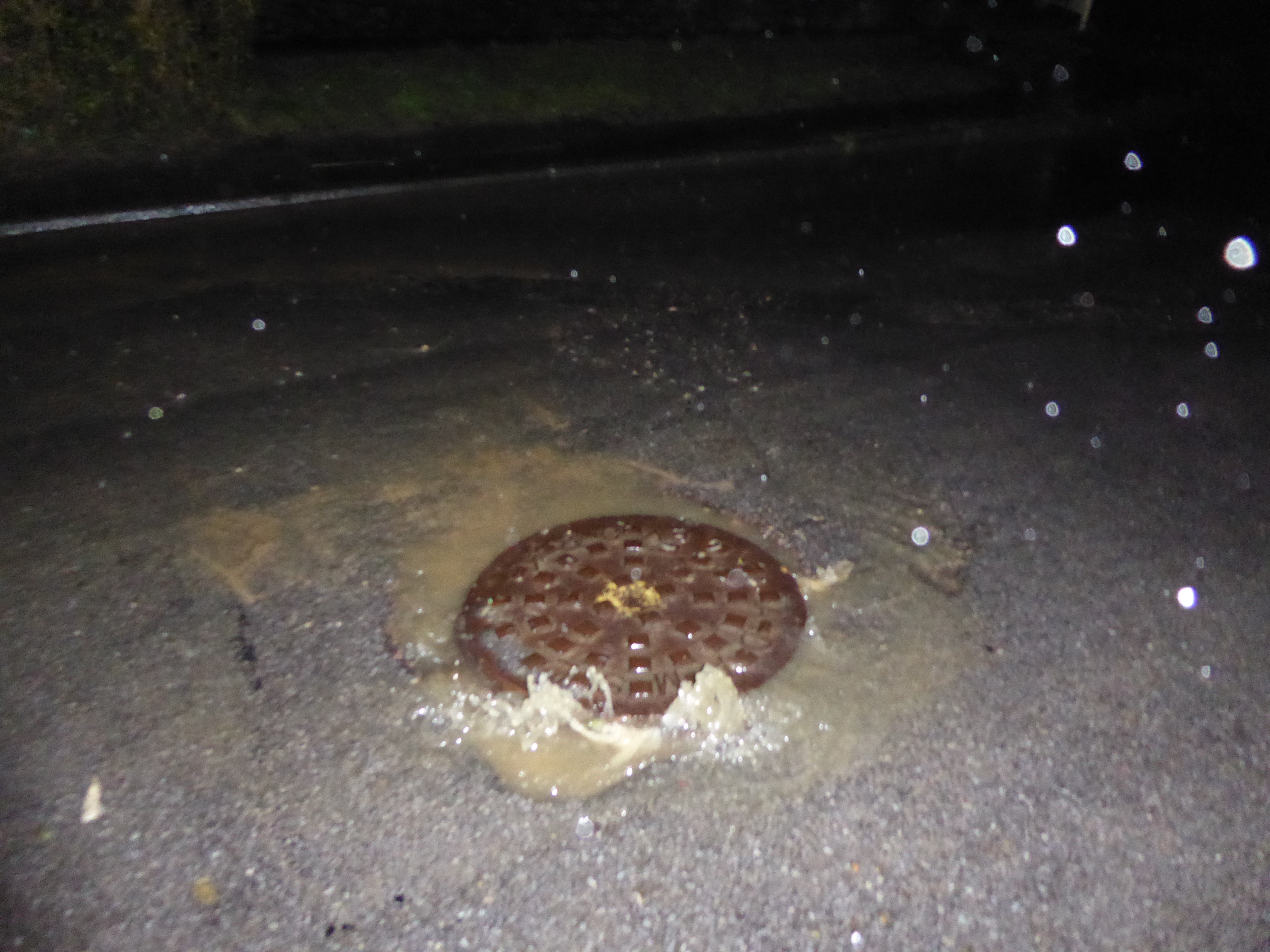
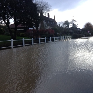
Further sewage egress in Fressingfield
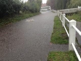
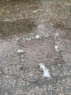
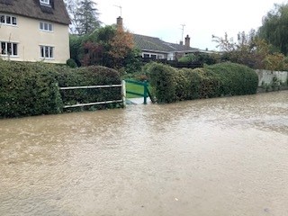
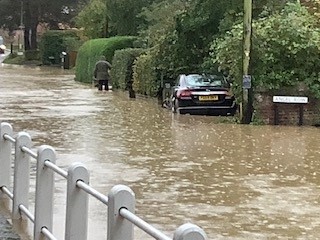
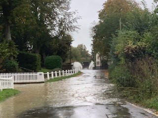
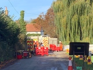
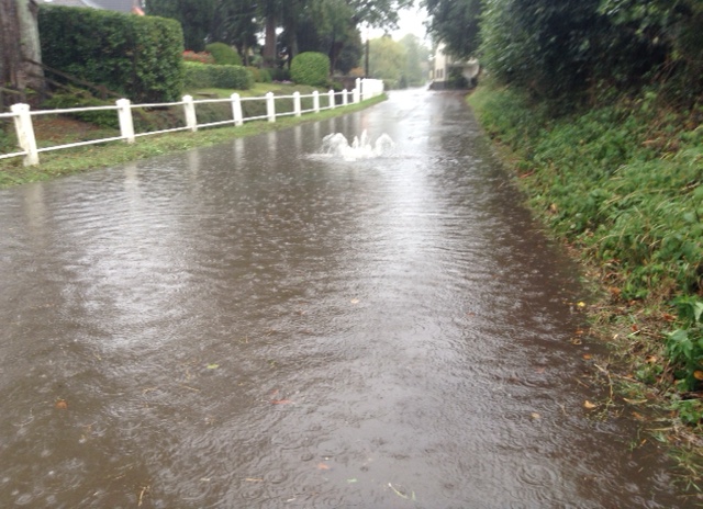
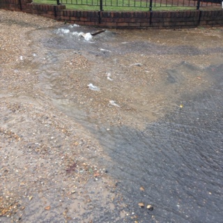
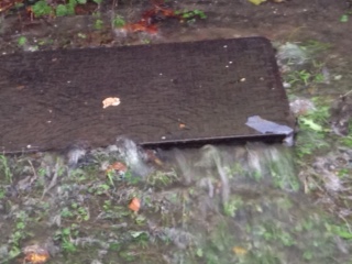
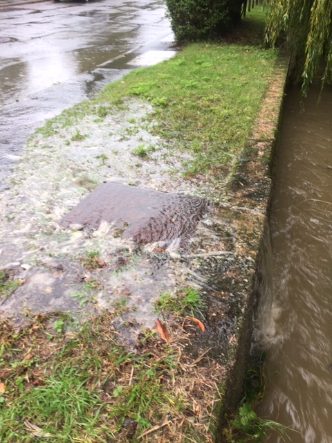
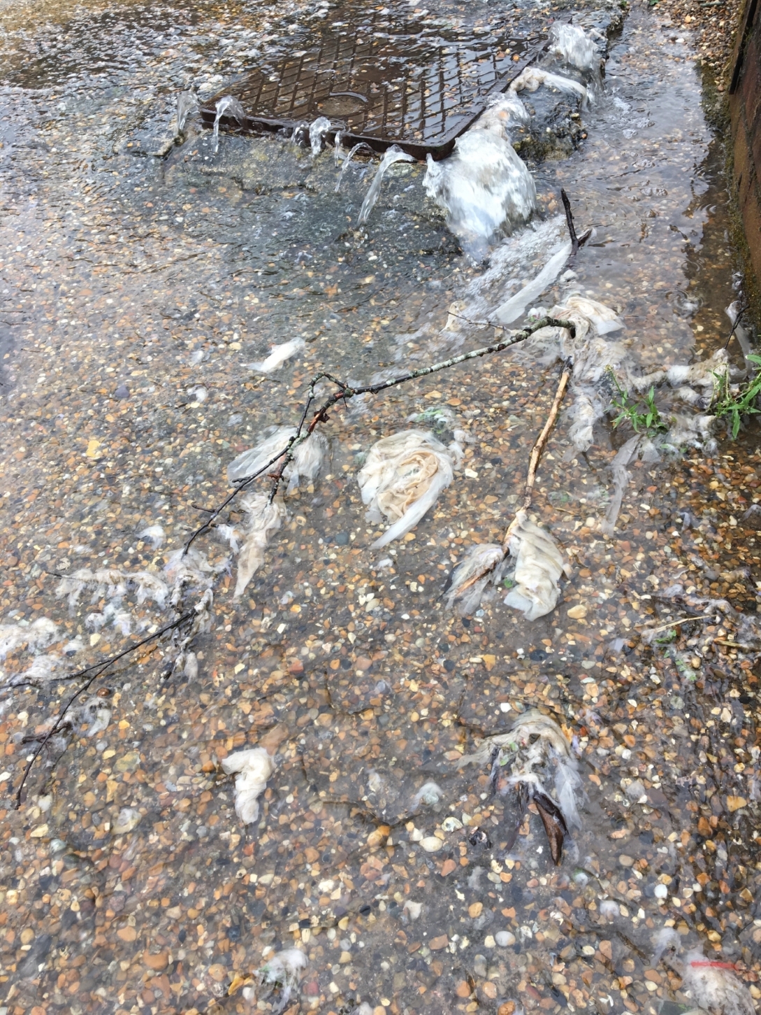
There was a further episode of sewage egress in Low Road/Cratfield Road, Fressingfield on Monday 20th October 2025, following a short period of heavy rainfall.
We noticed the overflow at 1pm and lasted approximately 45 minutes, but it probably preceded our observations .
Toilet paper debris was noted on the manhole covers and the highways drains which discharge into the Beck. The Beck remained low and did not overtop.
Two covers were discharging sewage. Photographs were taken and the incident reported to the Environment Agency (02437490) and Suffolk County Council. (00538461)
This is the 7th incident of sewage egress since the major works were undertaken by Anglia Water in October 2022. This figure may be an underestimate as we could miss events happening after dark or when we and others are away.
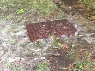
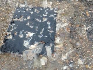
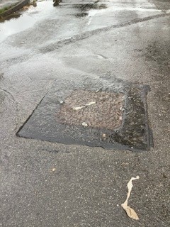
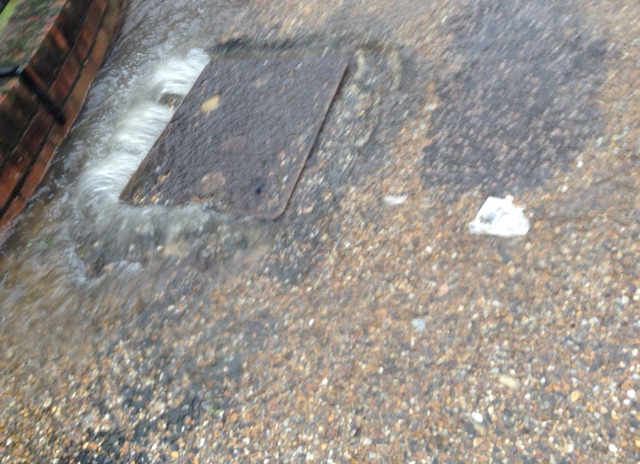
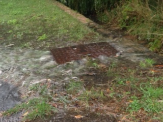
Attached are three pictures taken on 20th October. Two show toilet paper coming through the sewer covers and one of the highways drain with toilet paper on the grid.
Road drain which drains into the Beck
Manhole cover with toilet paper
Different manhole cover with toilet paper.
JC & PC 20.10.25
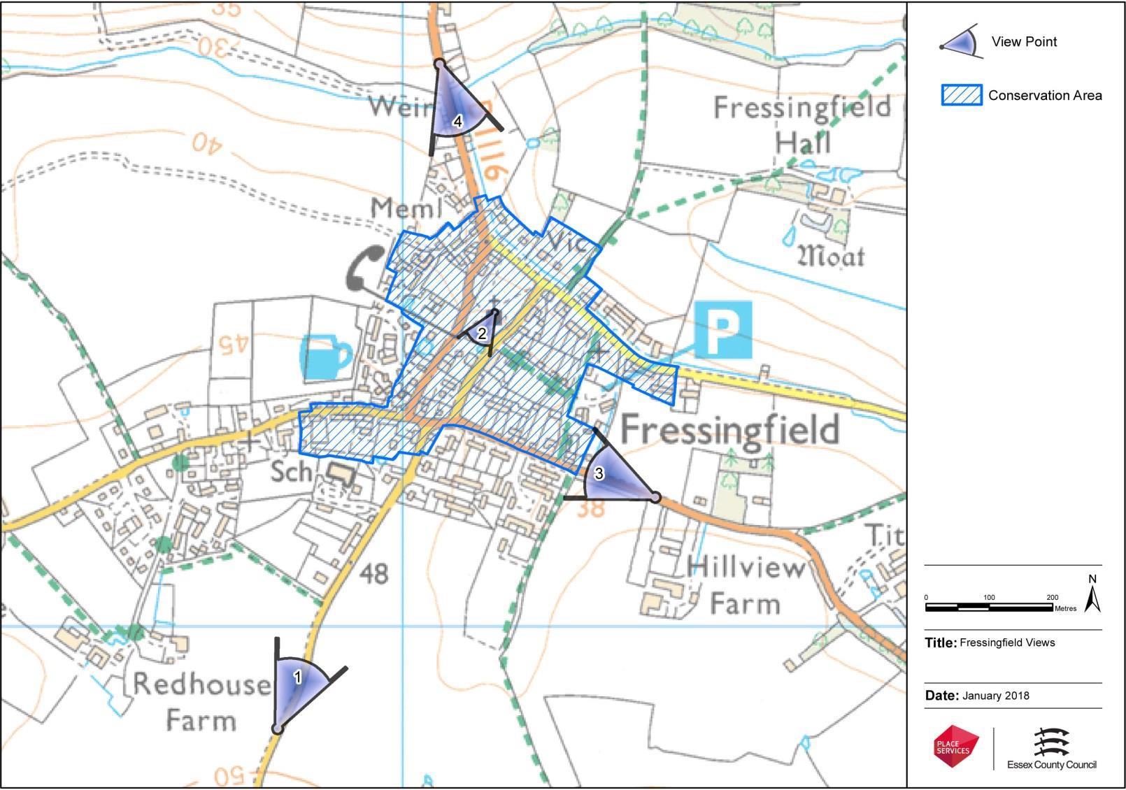
The Importance of Safeguarding Fressingfield’s Heritage
Notwithstanding pressure for local councils to acheive housing goals, and regardless of whether there is a Neighbourhood Development Plan in place or not, there are stringent rules to protect the setting and context of Heritage sites.
The National Planning Policy Framework (NPPF) revised in December 2024 (with minor amendments in February 2025) provides the definitive guidance on heritage in the planning system, not a separate 2025 edition. It requires local planning authorities to have a positive strategy for the conservation and enjoyment of the historic environment, identifying opportunities for enhancing heritage assets.
Heritage incorporates both environmental and historical setting.
Fressingfield should be protected, having both a beautiful pituresque and peaceful rural setting which brings in many tourists to the area; but also having 58 listed historic buildings, a high proportion in such a small village.
The importance of recognising heritage assets cannot be ignored or underplayed, it has vital importance to the planning process. Heritage assets are legally given protection and planning law clearly lays out that they are respected and enhanced.
Councils and decision makers should be mindful that once heritage assets – whether that be unspoilt countryside, environment, biodiverse corridors or ancient heath and woodland or historic buildings – are lost, they are lost for future generations forever and these sites should be safeguarded and protected against inappropriate development.
Some of the clauses of the NPPF set out to :
contribute to and enhance the natural and local environment by:
a) protecting and enhancing local landscapes,sites of biodiversity or geological value and soils (in a manner commensurate with their statutory status or identified quality in the development plan);
b) recognising the intrinsic character and beauty of the countryside, and the wider benefits from natural capital and ecosystem services – including the economic and other benefits of the best and most versatile agricultural land, and of trees and woodland;
c) maintainingthecharacteroftheundevelopedcoast,whileimprovingpublic access to it where appropriate;
d) minimising impacts on and providing net gains for biodiversity, including by establishing coherent ecological networks that are more resilient to current and future pressures and incorporating features which support priority or threatened species such as swifts, bats and hedgehogs;
Interestingly there is also a clear call for sites to be protected from pollution and flooding:
preventing new and existing development from contributing to, being put at unacceptable risk from, or being adversely affected by, unacceptable levels of soil, air, water or noise pollution or land instability. Development should, wherever possible, help to improve local environmental conditions such as air and water quality, taking into account relevant information such as river basin management plans; and land instability.
Planning policies and decisions should also ensure that new development is appropriate for its location taking into account the likely effects (including cumulative effects) of pollution on health, living conditions and the natural environment, as well as the potential sensitivity of the site or the wider area to impacts that could arise from the development. In doing so they should:
a) mitigate and reduce to a minimum potential adverse impacts resulting from noise from new development – and avoid noise giving rise to significant adverse impacts on health and the quality of life72;
b) identify and protect tranquil areas which have remained relatively undisturbed by noise and are prized for their recreational and amenity value for this reason.
Not only sites of special scientific or historic interest are protected but places such as Fressingfield:
When considering the designation of conservation areas, local planning authorities should ensure that an area justifies such status because of its special architectural or historic interest, and that the concept of conservation is not devalued through the designation of areas that lack special interest.
Proposals affecting heritage assets must identify the significance and potential harm to any heritage assets including their setting:
In determining applications, local planning authorities should require an applicant to describe the significance of any heritage assets affected, including any contribution made by their setting. The level of detail should be proportionate to the assets’ importance and no more than is sufficient to understand the potential impact of the proposal on their significance. As a minimum the relevant historic environment record should have been consulted and the heritage assets assessed using appropriate expertise where necessary. Where a site on which development is proposed includes, or has the potential to include, heritage assets with archaeological interest, local planning authorities should require developers to submit an appropriate desk-based assessment and, where necessary, a field evaluation.
Local planning authorities should identify and assess the particular significance of any heritage asset that may be affected by a proposal (including by development affecting the setting of a heritage asset) taking account of the available evidence and any necessary expertise. They should take this into account when considering the impact of a proposal on a heritage asset, to avoid or minimise any conflict between the heritage asset’s conservation and any aspect of the proposal.
It is by conserving historic heritage that communities can remain sustainable and attractive places to live, keeping their distinct and unique local character.
This is irrespective of whether any potential harm amounts to substantial harm, total loss or less than substantial harm to its significance.
Any harm to, or loss of, the significance of a designated heritage asset (from its alteration or destruction, or from development within its setting), should require clear and convincing justification. Substantial harm to or loss of listed buildings should be exceptional and avoided at all costs.
Abi Maydon, on behalf of SAFE 29.9.25
Forthcoming Call for Multiuse Sites – Babergh and Mid Suffolk Local Plan Review
Babergh and Mid Suffolk, as part of the development of the Local Plan, will issue a further call for sites. This invitation relates to sites with potential for mixed use..
The Local Authority have stressed there is no need to resubmit sites already been proposed ( there are 5 major sites in Fressingfield). The Local Authority confirm that that the process “ does not allocate sites fordevelopment and has no planning status.”
Infrastructure is the facilities and system that serve a country, city or other area and encompasses the facilities necessary for the economy, households and firms to function. In a community it includes such things as roads, transport, water, sewage, open spaces etc. In the adopted NDP (March 2022) it states. “New developments will only be permitted if it can be demonstrated that sufficient supporting infrastructure is available to support the needs of that development. There is a significant infrastructure deficit in Fressingfield and new development will exacerbate that deficit.” The deficiencies are as follows:-
Inadequate sewerage provision
This is a long-standing problem. In March 1937 there was consideration of building a partial sewerage system to abate the sanitary problems in the Fressingfield Beck in Low Road This served as the outfall for the ditches and sewage throughout the village. This outfall was the receptacle for house refuse and other filth.
A sewerage scheme was approved, but was delayed because of WW2 and was not completed until 1946.
Currently there is a “foul only” sewerage system in Fressingfield which runs along the centre of Low Road. It is joined by a further sewer pipe close to the War Memorial draining some of the upper part of the village and is then pumped along the Weybread Straight to the sewage treatment plant in Weybread.
Surface water drainage should be totally separate (but it is not)
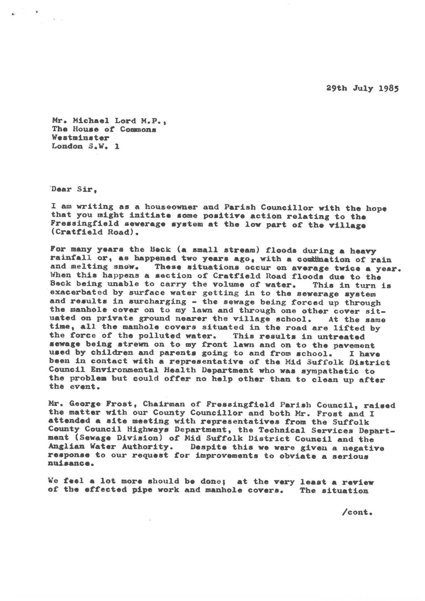
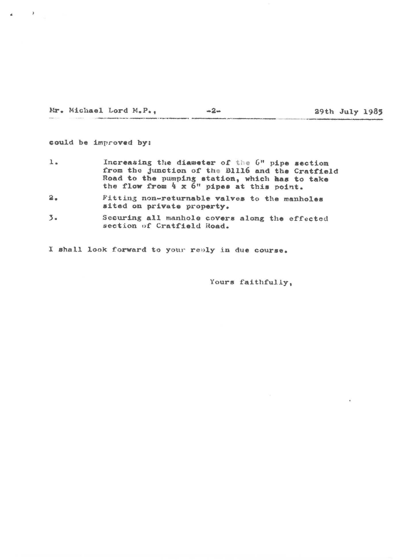
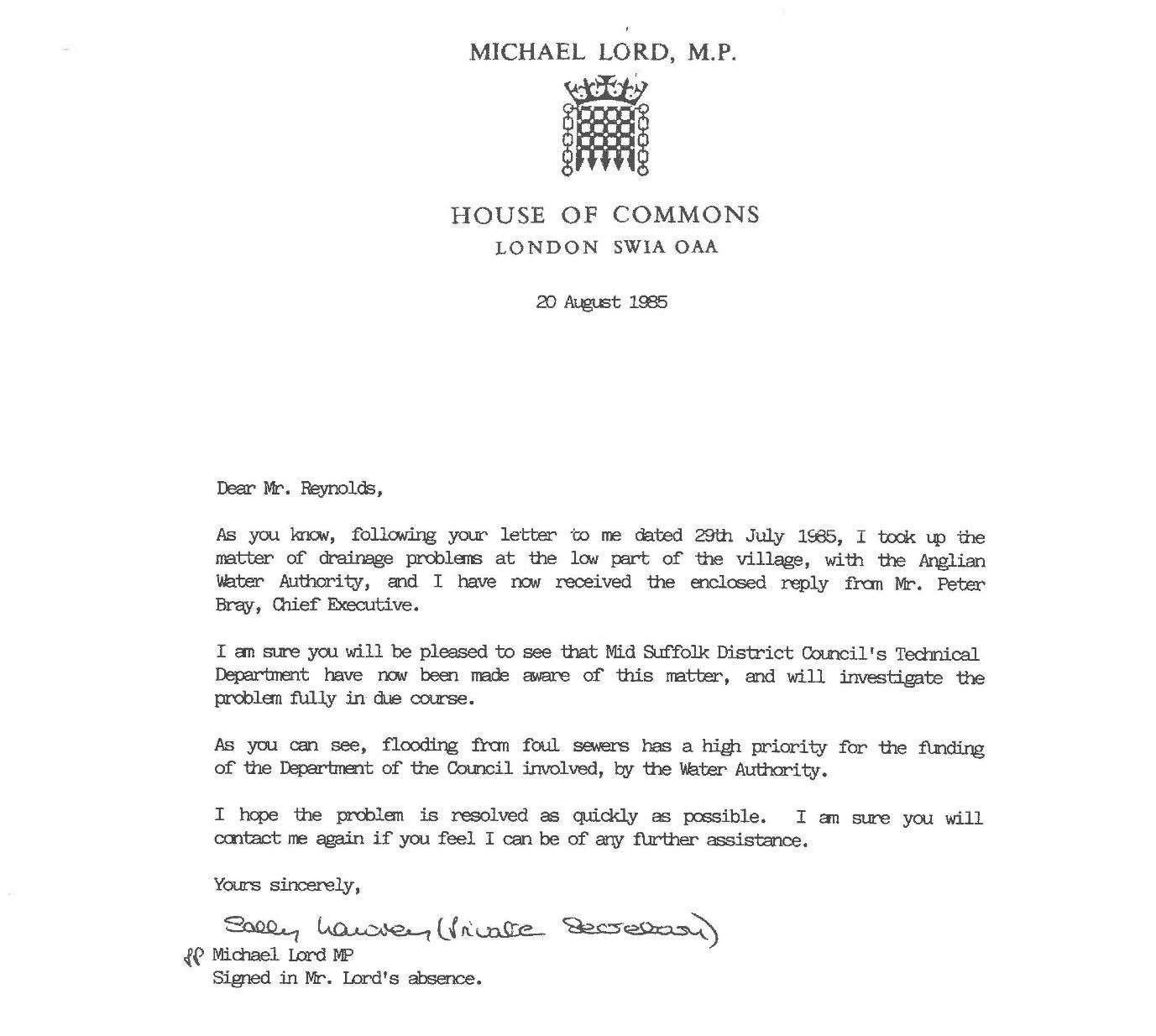
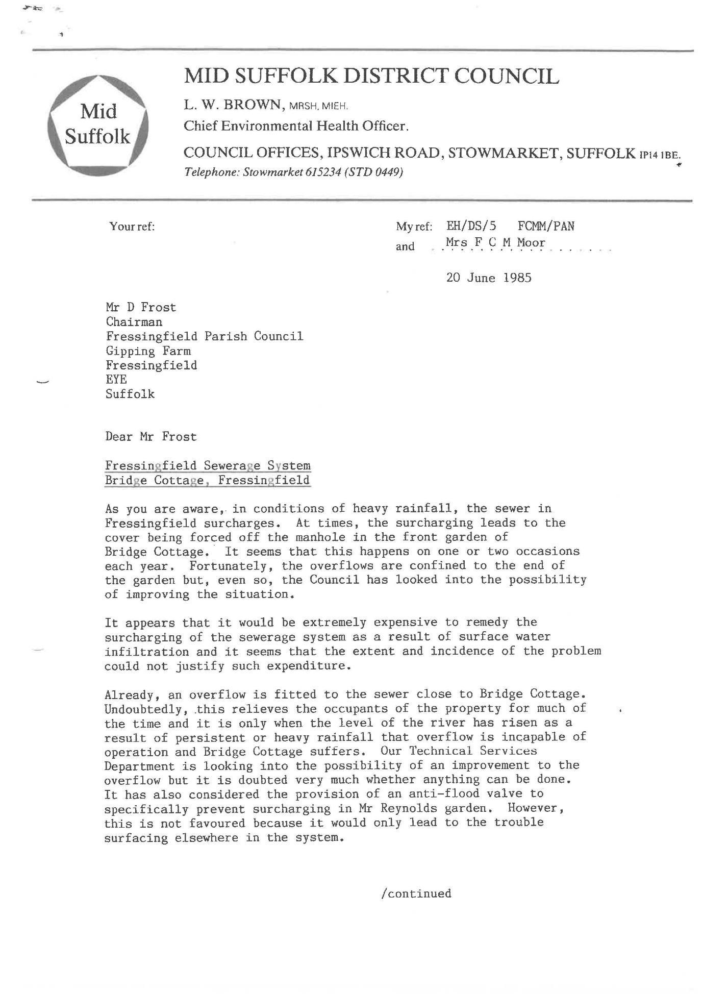
Overflow of the foul only sewer is first formally recorded in 1985 in correspondence between Norman Reynolds (of Bridge Cottage Low Road), the local MP (Michael Lord), the then Chief Executive of Anglian Water (Peter Bray), and Mid Suffolk District Council, acting as the agent for Anglian Water.
After investigation it was concluded that “the Council feels unable to solve the problem”. Sewage egress occurred about twice a year. A mixture of water and sewage surcharged out of the manhole covers. The important point is that any surface water in Low Road (with or without sewage) passes directly into the Beck via road drains on the north side. The only help offered was that the Council would help clear up any deposits remaining after the surcharge.
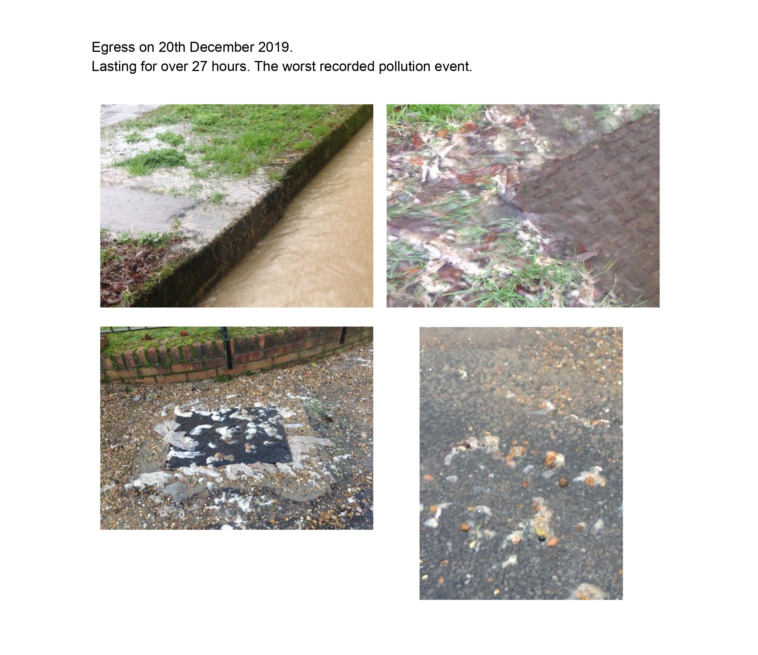
At present the situation has not changed. Initially there were sporadic, poorly documented reports. In 2016 has records of 2 incidents. In 2017 two incidents were photographed, but not reported. Systematic reporting commenced in April 2018. From that time details and photographs of known incidents have been reported to the Environment Agency. Between April 2018 and October 2021 15 episodes were reported. In October 2022 major works were undertaken by Anglian Water (see later), but since then a further six episodes have occurred. (full list appended). There may have been other episodes over night which would not be reported. Any egress coming from the manholes will inevitably drain into the Beck and contaminate the water course. Reporting to the Environment Agency is important.
The duration of these incidents is variable, but is on average about 6 hours. The longest recorded was 27 hours in December 2019.
The major work undertaken by Anglian Water in October 2022 involved relining the main sewers and laterals in Low Road. Tree roots in the sewer were also removed. This work was to make the sewers water tight and prevent the ingress of surface water into the foul only sewer. Investigation by Anglian Water have demonstrated that historical surface water drainage from individual homes are discharging into foul sewer.
Suggestions have been made to solve the problem of sewage egress.
-Screwing down the manhole covers. This can cause back pressure into houses with retrograde flow of foul water into sanitary ware.
– Fitting non-returnable valves to the manholes. This would transfer the problem to another part of the system.
– Increasing the diameter the pipework. In summer when flows are slower this would result in blockages and smells.
– providing localised sewage treatment plants for individual new properties. This would have no impact on the current situation, but would result in the problem not being compounded. Unfortunately, the Environment Agency will not approve localised treatment plants when it is practical to connect to an existing mains system.
– To remove historical rain water connections from individual houses. There is no budget for this, nor legal powers. Soak aways are the alternative, but they are costly to install and need maintenance and do not work well on clay.
– To install water butts. These would only make a minute contribution and they overflow at times of heavy rainfall.
– Pressure flow recorders have been installed in the sewers since 2022. These help localise a problem, but are not in themselves a solution.
-Preventing new build properties. All new builds in the village will be discharging foul water into the sewer. This will exacerbate a pre-existing problem. However, Section 94 of the 1994 Water Industry Act places a legal obligation on Water companies to ensure effective drainage of an area.
More houses discharging foul sewage into the sewerage will result in less capacity for surface water and thereby increase flooding and this flooding is likely to increase the concentration of foul sewage.
Medical Consequences
In May 2018 the then Director of Public at Suffolk County Council wrote
“I would agree that the situation relating to sewage leaks is not acceptable and unpleasant. – I have informed Public Health England of the situation.”
The Senior Case Officer at MSDC, Vincent Pearce, in his report to committee in November 2018 concerning three major planning applications in Fressingfield wrote.
“The pollution of parts of the village and the Beck, however occasional, with raw sewage, sanitary products and toilet paper is unacceptable pollution that will only worsen with significant levels of new development connecting to the Fressingfield foul water system. As it becomes increasingly common to experience extreme weather conditions in the UK it seems ridiculous and completely unacceptable to expect local people to endure what at times looks and smells like a medieval living environment.” ( Para 4.13.11)
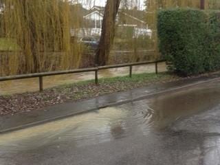
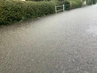
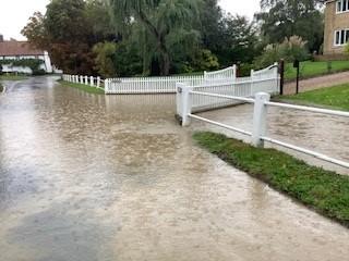
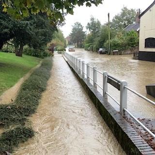
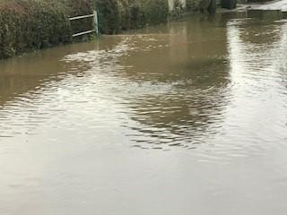
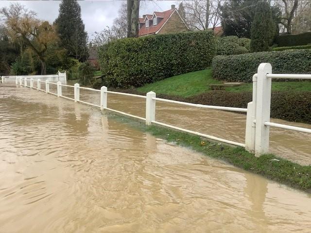
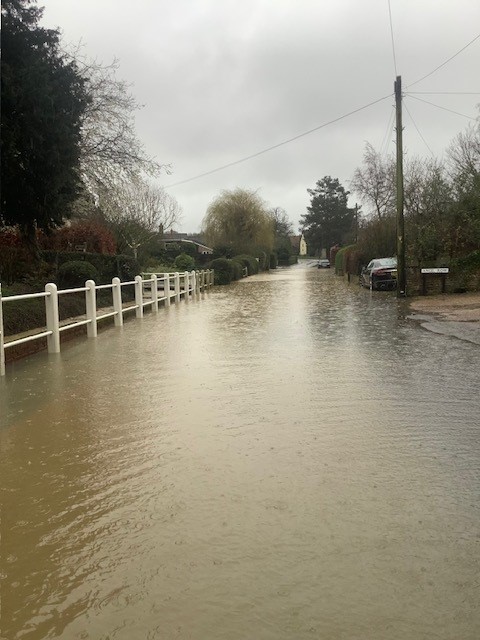
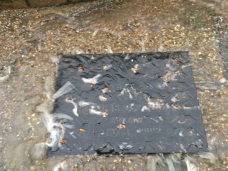
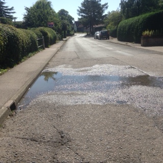
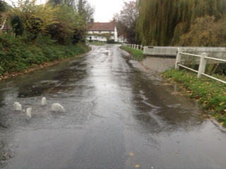
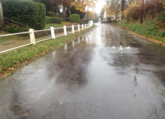
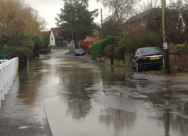
Surface Water Flooding
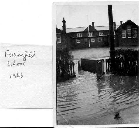
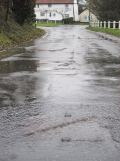
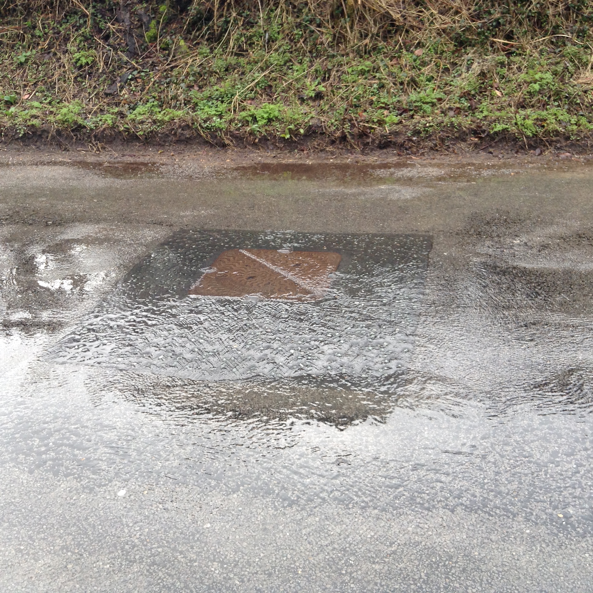
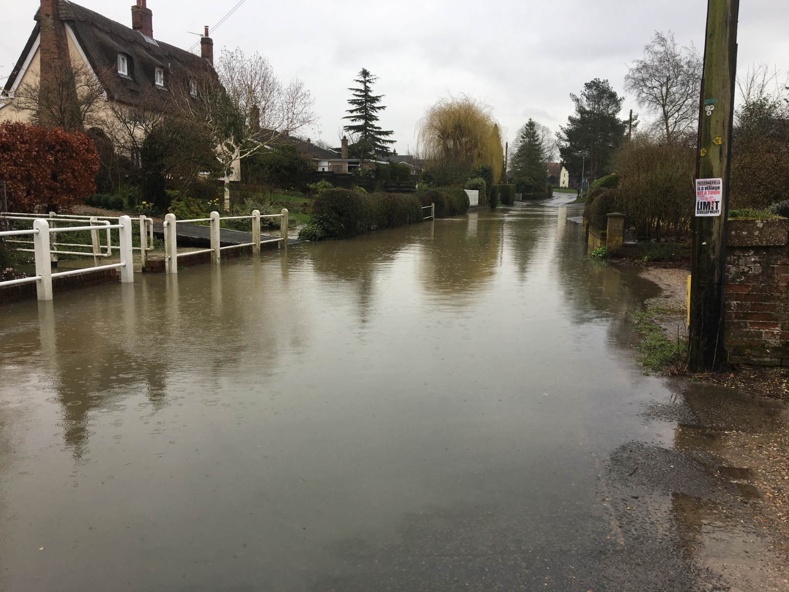
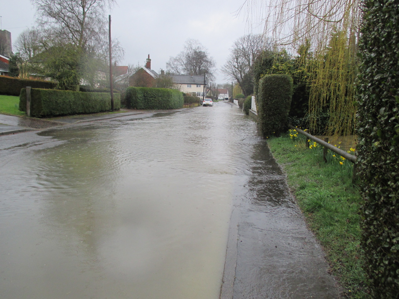
Fressingfield is subject to surface water flooding, which at times can be severe. Older, long term residents remember that children at the old school finished early when heavy rain was forecast. “The Low” being an area often subject to deep flooding.
The village of Fressingfield subject is to flooding. It is surrounded by hills, Buckingham Hill, Harleston Hill, Church Hill. All the hills drain down towards Low Road and discharge surface water and water through highways drains into the Beck.
Over topping of the Beck occurs and floods Low Road and Cratfield Road. Sewage discharging from the manhole covers adds to this. Flooding can occur in summer as well as winter.
Flooding is under reported by residents because of a fear of affecting insurance premiums.
More building will inevitably increase the amount of hard standing and roof areas. It is critical that the surface water hierarchy is strictly adhered to. Sustainable drainage systems are difficult to achieve in Fressingfield because of the underlying heavy clay – Whilst developers are required to conform to the drainage hierarchy there will always be concern as to how robust its implementation will be and in the long term will the necessary maintenance be undertaken.
Medical Services
Despite the best endeavours of the staff there are difficulties with the medical centre. The surgery is situated in New Street with a branch surgery at Stradbroke. It is a dispensing practice. The catchment area is 115 square miles. There has been a large amount of new development in the area with a significant amount of increased population. The surgery no longer offers a service for “life threatening conditions” and there is no “First Responder “service in the village. Any serious emergency necessitates a 28 mile journey to the nearest hospital.
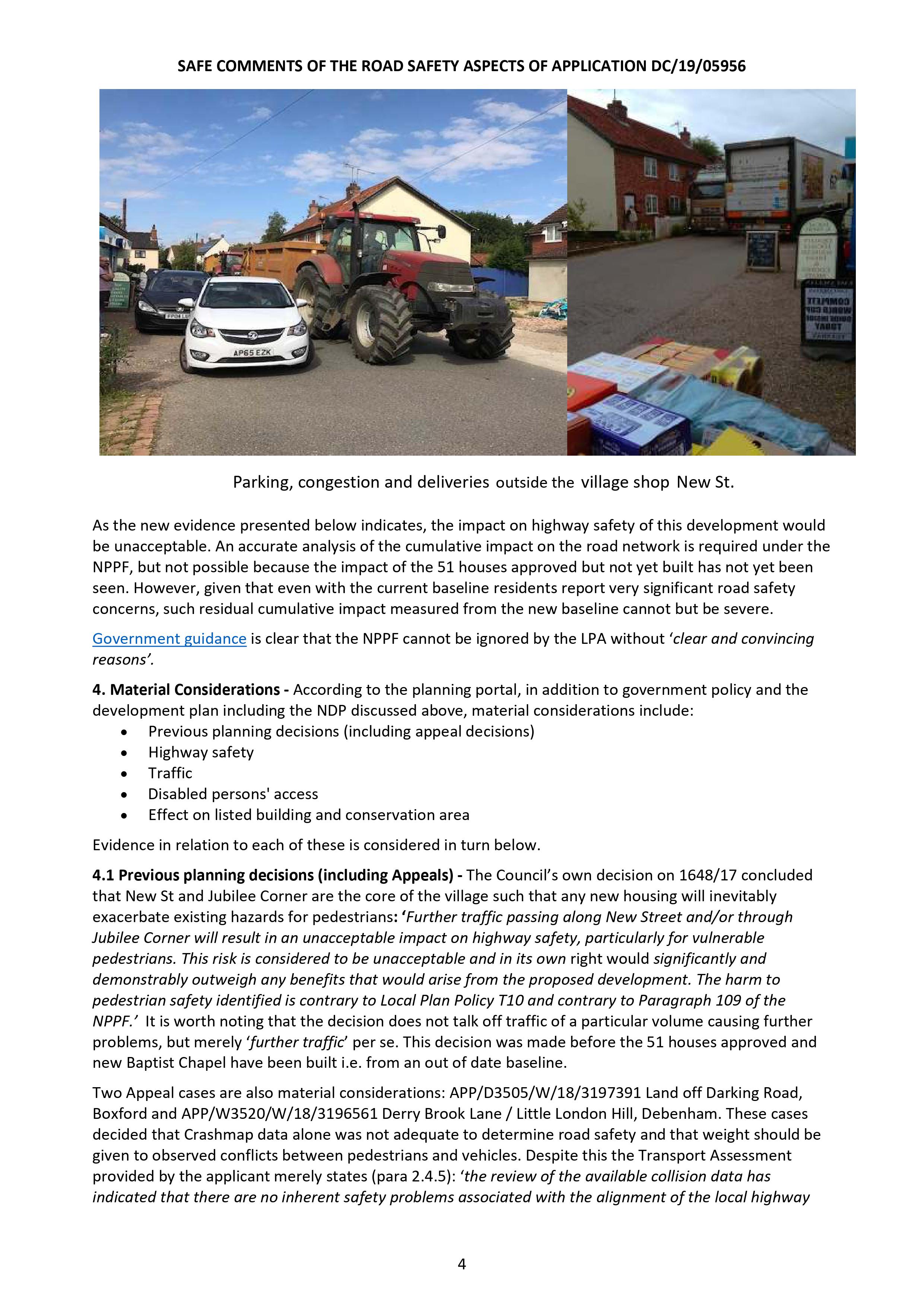
There are no universal footpaths to the surgery making the journey difficult and hazardous There are no public transport for the majority of patients the only way to get to the surgery is by private car. Car parking is inadequate. Staff use the same car park, consequently parking on New Street commonly occurs adding to the congestion in New Street.
In 2000 routine appointments were offered with a GP the same day or the following working day. Such appointments are now commonly delayed for three weeks. There is no doubt the practice has experienced a massive increase in work load which will only increase with further developments.
Transport and Highways
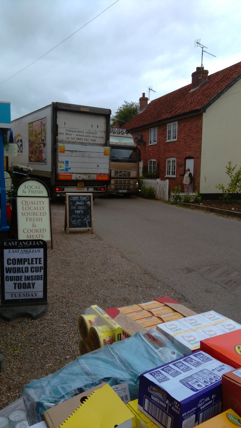
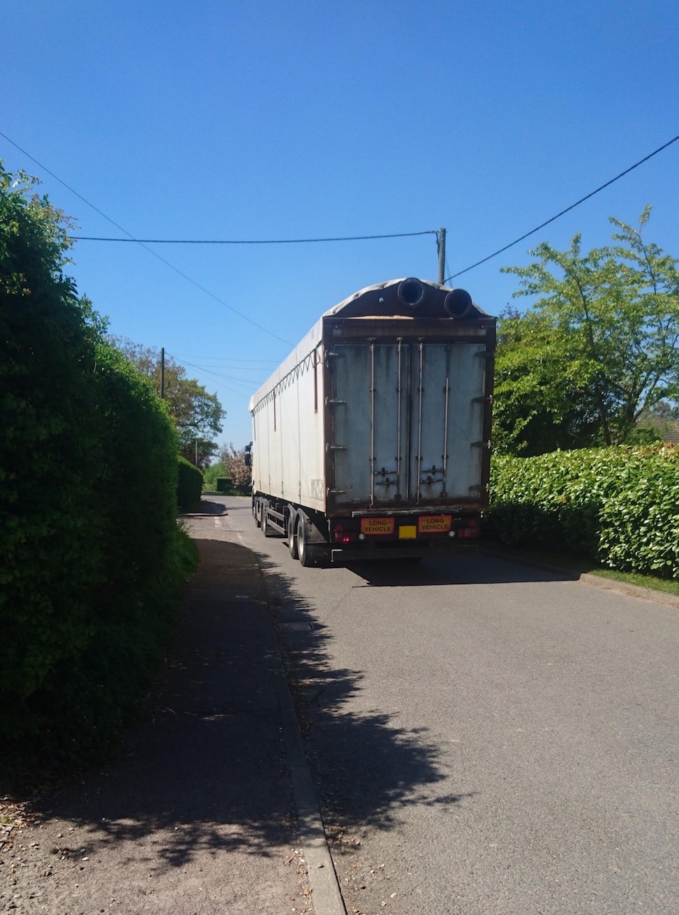
Fressingfield has NO public transport and very few local job opportunities. For the majority the only way to go to work is by car.
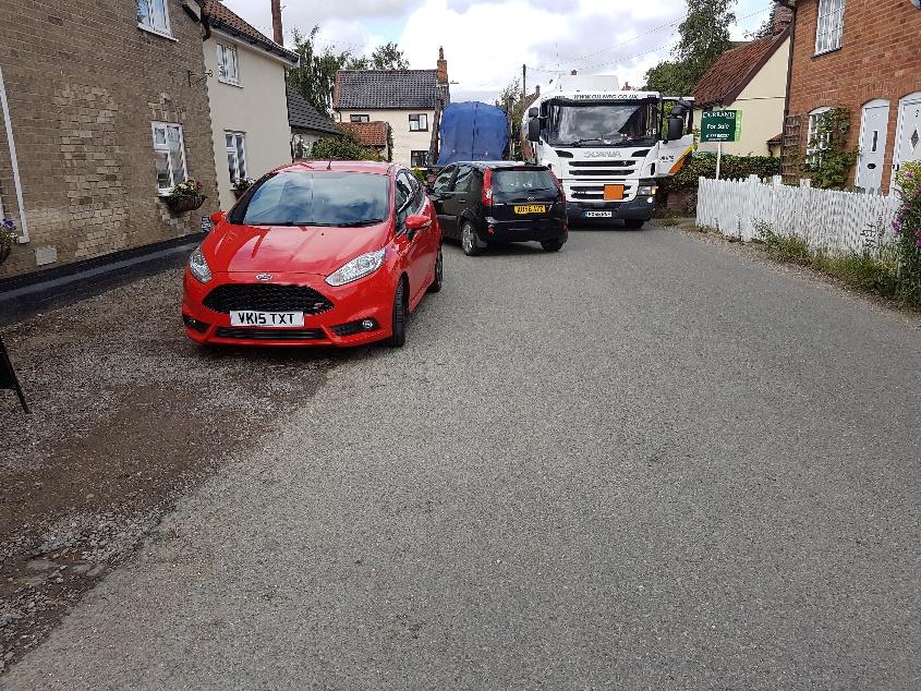
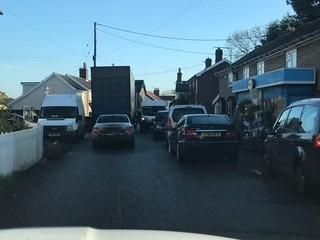
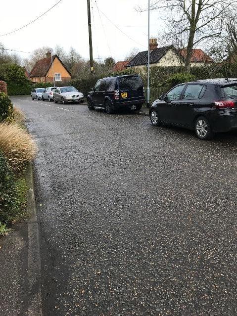
In 2020 SAFE undertook an online anonymous road safety survey. 104 people responded. All but 2 owned a car and 19% owned 2 or more cars. Only 7 people reported that they felt safe whilst walking in the village whereas 87 people “always” or “often” felt unsafe when walking in the village. New Street was identified as an unsafe area. This area is particular busy with both the shop and surgery being located there. Jubilee Corner, a five way junction with is also identified as a hazardous area.
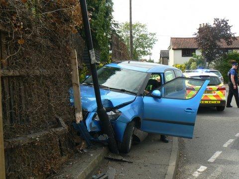
On street parking is very common, there are NO cycle lanes. There are a number of minor accidents that go unreported. Further increase in traffic is bad for the environment and difficult for the disabled.
Biodiversity and Green Issues
Recent housing developments have further eroded the Green Spaces within the Settlement Boundary. Fressingfield has 58 listed buildings and it is their setting and that of the village which will be ruined for future generations if inappropriate development is approved. The NDP highlighted the view of the village from the Stradbroke Road as an important vista. This has already been altered by inappropriate tree removal.
Long term climate change predictions (2025) indicate warmer wetter winters and hotter drier UK summers with more frequent intense weather extremes. This has implications for sewage egress, flooding, and water shortages.
Water Supply
The Hartismere Water Catchment Area (which includes Fressingfield) has issues with water supply. No new industrial units requiring significant amounts of water are to be given permission to draw from the mains supply. The alternative of providing more bore holes is not encouraged because of the impact on existing bore holes and the water table. There are plans to improve the situation, but these will take at least 5 years to implement.
Conclusion
This is a summary of the infrastructure deficit in Fressingfield and an explanation of the implications and origins of the deficit.
Note
Only representative pictures of flooding and sewage egress are shown. Many more are available.
The pictures from Stradbroke Road are one of the important vistas in the village, and the altered appearance was investigated by the local Authority Ombudsman.
25 September 2020 – 1851349 (Anglian Water 57968909)
20 November 2020- 1863477 (Anglian Water 58179677)
4 December 2020- 1868511 (Anglian Water 58256966)
23/24 December 2020 – 1872804 (Anglian Water 58337816)
5/6 January 2021 – 1876466 (Anglian Water 58379563)
14 January 2021- 1879315 (Anglian Water 58414646)
28 January 2021 – 1885370
29 January 2021 – 1885168
5 October 2021 – 1999862 (AW 59592060)
Major work under taken by Anglian Water in October 2022
20 October 2023 – 2196521
2nd November 2023 -2200802
2 January 2024 – 02233999
18 February 2024 02232748 (Suffolk County Council Flood Report 00453643)
26 May 2024- 02271170 (Suffolk CC Flood report 00473225)
1 October 2024 02310839 (Suffolk CC Flood report 00491577) (AW 26391435)
Planning Serendipity
Introduction
This paper draws together various pieces of information not specifically relating to Fressingfield which I have gleaned from a meeting of SAFE representatives with Councillor Stringer, (Cabinet Member for Heritage, Planning, and Infrastructure at Mid Suffolk District Council) and a Developer. Both have been helpful in providing an insight into how the process works and why there is such an affordability gap for first time buyers.
The Developer’s Perspective
I asked him a number of questions around affordability and profit margins. The quote below is pasted from an email to me. I find the comment about 2-bedroom houses in rural locations particularly interesting.
“The profitability of 2 bed units compared to 4 bed is really all about location.
For example if we had one large property in say a town location we would prefer to make 2 smaller ones it would be more profitable.
However, in a more rural location a larger property is more profitable. as you achieve more per sq ft this way.
The planners are encouraged to insist on smaller units to encourage younger people to villages, they also see them as more affordable, but it’s not great for us as most youngsters prefer the facilities in a town, making these units quite a challenge to sell and achieve a decent price.”
Developers do not make a loss on building affordable units, but the profit margins are much smaller than on market housing.
Councillor Stringer’s Perspective.
The “target” 122 housing figure set by MSDC could rise. (this figure takes NO account of local infrastructure and is based on a crude mathematical formula). Councillor Stringer indicated that Ipswich was failing to meet its housing targets and this was creating a ripple effect with villages having to accommodate more housing to meet the Ipswich shortfall. He confirmed that the targets set by central government for Mid Suffolk were “challenging.”
Councillor Stringer confirmed that MSDC will not be building any council houses.
Whilst the Neighbourhood Development Plan ( NDP) is a legal document which forms part of the Local Authority Development Plan Councillor Stringer did confirm that the Design Codes could not be enforced. Developers like large sites using standard designs used across numerous sites, thereby benefitting in bulk purchasing. I am sure you will have noticed identical Hopkins houses in Saxmundham, Framlingham and Halesworth. The NDP will not influence the design of the houses built. The current adopted NDP had an excellent section on design, but this had no impact on the approved design of the houses at Red House Farm. Full Planning approval for the site was granted after the adoption of the current NDP.
There have been cases in Mid Suffolk where an NDP has been voted down at the referendum stage. It is strongly advocated that there be openness and transparency with communities in the preparation of Plans to avoid this happening. There has not been openness and transparency to date in the review of the Fressingfield NDP.
Management of Affordable Housing
There is now a new issue. “Affordable “housing is managed by Registered Providers. These are usually Housing Associations who take over the ownership and management of the affordable housing. For example, Sanctuary Housing manage Chapel Close and Orwell Housing have been appointed to manage the 9 houses at Red House. House prices have fallen very slightly, but are still extremely high and Housing Associations are short of funds. I have heard of a site where no Registered Provider is prepared to take over the affordable element.
A housing industry coalition has written to Matthew Pennycook, the housing minister, to warn that providers of social housing “are struggling to fund required improvements to current housing portfolios, let alone deliver new homes.”
Currently new builds are falling behind target.
Are Affordable Homes Truly Affordable?
There is common ground that first time buyers should be in a position to buy their first home.
Communities support affordable housing in the mistaken belief that this supports young people ingetting on the housing ladder. The Parish Council commissioned a Housing Needs Assessment from a consultancy company- AECOM. The report for Fressingfield was produced last Autumn. It still has not been made publicly available, but I have looked at a published AECOM report for a similar village and this clearly demonstrates that even shared ownership schemes are not affordable for the majority, I suspect the situation will be the same in Fressingfield. This is borne out by the fact that of the 9 affordable houses at Red House 7 are social rent and only 2 are shared ownership. Most affordable houses are therefore subsidised rental properties and have nothing to do with assisting first time buyers to buy a house.
Financial support for the housing Sector
The “Help to Buy Scheme “ended in March 2023 and those attempting to get on the housing ladder have been without any kind of government support for the first time in 60 years.
Neil Jefferson, the CEO of the House Builders Federation stated “All indicators for housing supply continue to stagnate or to go backwards.” Demand is slowing because of affordability issues and a general lack of confidence.
The Spending Review on 11th June 2025 has recommended that spending on social housing will increase from an average of £2.3 bn a year to £3.9bn a year over the next 10 years. The details will only become clear in the Autumn budget. This will take time to implement. Several house builders, including the chief executives of Persimmons and Barratt Redrow have indicated that the key to stimulating demand will be to reintroduce some form “Help to Buy “scheme.
Research by Savills indicates that the Government will only achieve 840,000 new homes in the next 5 years, not the 1.5 million target. Other industry experts do not think the 1.5million homes in 5 years is realistic. Currently the Government are committed to the 1.5m figure. If the figure is reduced then there should be an impact on the 122 homes for Fressingfield, but in any event the infrastructure in Fressingfield cannot sustain 122 new houses.
The impact of the spending review announcement will not be known for some time, but in the period, material costs will continue to increase (they increased 30% in the last 2 years); labour costs will increase with wage inflation and the change in Employer NI contributions and other on costs such as the levy on all new builds to pay for cladding rectification will be introduced. How much of the proposed new monies will be taken up by inflationary pressures is unknown.
Phasing of developments
The current housing “target “set by MSDC for Fressingfield is 122 houses over a 20-year period. Six houses per annum does superficially sound reasonable. The NDP might advocate phasing of small developments over the plan period, but this will not be enforceable. It is highly likely that land owners will apply for major developments up front, all but one of the sites proposed will accommodate around 100 houses plus. My view is that whatever the policy statement is within the NDP MSDC will support an application for very major developments for the following reasons. Local Authorities are under intense pressure to deliver housing numbers to meet the Government target of 1.5 million within the life of this Parliament ( not over 20 years ): MSDC will be aware that if they do not approve major applications central Government will be seeking powers to intervene and take executive decisions: small scale developments will not deliver any affordable housing, whereas large developments will include one third affordable homes: there is within the village a developer who has demonstrated he is very keen to submit applications for large scale developments. The scene is therefore set for large up-front developments regardless as to policies within the NDP, should phasing be advocated as a policy.
It is the developers who makes and details the Planning Application and the who sets the build out rates, not the NDP nor the Local Authority and they (the developers) are not going to build at a loss.
Development site layouts
National and local planning policy recommends “pepper potting “of social housing within developments. That is not grouping them together on a site, but to spread them across a development to encourage social integration. In practical terms this does not happen as Registered Providers (usually housing associations) like to have the social housing grouped in terrace accommodation for ease of maintenance and general management. For example, it is much easier and cheaper to replace a roof on 4 terraced houses than 4 houses spread across a site. Developers also ignore this policy as a terrace is cheaper to build. An example of a well-intentioned policy being ignored because of the practical limitations.
Conclusion
The delivery of good quality affordable housing for first time buyers is challenging. There is a need for the right homes in the right places where there are jobs and good public transport. Introduction of a centrally funded scheme to subsidise first time buyers will seem to be the only way that home ownership can be achieved for many people.
Pam Castro
12.06.25
Critique of “The Housing and Environment Survey”
The Parish Council undertook a “Housing and Environment Survey” in March 2025 to provide evidence for the review of the Neighbourhood Development Plan. This Survey was sent to all people in the Parish over the age of 18. 907 forms were sent out and 324 residents responded. A response rate of 36%. The Parish Council has now completed their analysis of the data and the full results of the survey are attached click here to view together with the Parish Council summary of the results click here to view.
This is a critique primarily of the data analysis undertaken in response to the “Housing and Environment Survey.” A detailed analysis of the survey itself is not made. The way the data will ultimately be used is not stated, but we assume that it will be used as possible evidence for the Examiner.
The survey is supposedly on Housing and the Environment, but the major consideration is housing, with scant attention to the Environment.
The review of the raw data was to be undertaken by three independent assessors. BUT one was a Parish Councillor, the second was described by the Parish Council Chair as “an employee” of the Parish Council, and that there should not be direct contact with her. So hardly independent- “you do not bite the hand that feeds you.” The third is described as a colleague of the Parish Council employee. The three “independent” assessors all have direct links back to the Parish Council. In this situation there must be conflict of interest and a lack of impartiality.
In assessing the data much of it is subjective and not objective. Statements have not been quantified in any assessment.
Whilst the total response rate of 36% is satisfactory for this type of survey when the numbers for individual responses indicating a choice is very small. For example, in question 7 18 of the total of 324 respondents (5.5%) are interested in bungalows and this is reported as “there is also interest in bungalows.” In the same question 3 respondents express an interest in bedsits (<1%) and this is reported as “there is some interest in bedsits.” Whilst this is literally true the degree of interest is not significant and statistically makes no sense.
Summaries of the data are not representative and cannot be relied upon.
Comment on individual questions
Question 1 – “How old are the people in your household”
No comment.
Question 2 “Please tick below to describe your current home”
The summary is not clear – does the bedroom distribution include both houses and bungalows or houses alone. Why are they not placed in a logical order either number of bedrooms or number of respondents.
Question 3 “Which of the following would best describe your current home”
The respondent distribution is very different from the actual position in Fressingfield. For example, MSDC data identified 70 social rented properties in Fressingfield whereas there were only 10 respondents living in social housing. If the results of this question were to be used to assess the need for future social rented property the results would be very different to those based on MSDC data. This applies to much of the data analysis in this survey. To make important decisions better source material is needed.
Question 4 “Please indicate whether you or a member of your household is likely to need a home in the parish within the next 5-10 years”
These data only show that the older you get the more likely you are to need different accommodation in the future.
Question 5 “Are you looking for a larger or smaller place to live (please tick all boxes that apply”)
How many respondents were seeking both a smaller and larger property!
The analysis of this question fails to identify which age group responding are looking for a smaller house as the age of the respondent was not specifically posed in the survey. If all respondents are considered (324) only 10%, (not 90%) will need a property with less bedrooms.
Question 6 “If the following were available in Fressingfield parish, which would you be looking for? Please tick all boxes that apply
The summary states there is also interest in other forms of tenure, but the analysis does not identify how many respondents are voting for multiple options. For example, if 5 people voted for a number of options no conclusion could be drawn from these raw data, other than the majority are seeking an owner occupier home.
Question 7 “If you, or a member of your household, are seeking a new home in Fressingfield parish within the next 5years, please tick the type of property you think you would be looking for. “
The summary of these data is biased. One cannot deny there is some interest in flats, (4 people) bedsits (3 people) etc, but the numbers are very small and there is no indication as to whether the same respondent has ticked a range of accommodation.
Question 8 “If suitable accommodation were available would any close relatives not presently living in Fressingfield wish to live in Fressingfield”
A relatively small number- 57 people- would be interested in moving to Fressingfield. Much of the accommodation identified is already on the market in Fressingfield. It is surprising that much of the property on the market is taking a considerable time to sell and none of the houses at Red House Farm have been sold off plan. Other factors apart from living near to relatives must come into play.
It is significant that only 7 of the 57 people specifically mention affordable housing yet the summary specifically highlights this issue.
Question 9 “Have any other members of your family moved out of the area because they are unable or afford to buy or rent accommodation in Fressingfield”
Reasons for moving are multifactorial and it is difficult to isolate economic reasons alone. The figure of 57 is surprising as there are only 7 people with links to Fressingfield on the waiting list for affordable housing.
Question 10 “If Mid Suffolk District Council were to allocate more housing to Fressingfield in the future, how should that housing be distributed”
Once a site receives planning permission the build out rate is controlled by the developer. In principle builders will want large sites as they are more cost effective and produce greater profit. MSDC are likely to support larger development sites as these will contribute rapidly to the targets set by central government and will include affordable houses. Small sites will not have any affordable housing. The NDP policies will have no control over these factors.
Question 11 “The following sites have been put forward to Mid Suffolk District Council by landowners for potential future development. No decisions have been made on whether any of these sites are suitable for development. If Mid Suffolk District Council were to allocate more housing to Fressingfield in the future, which of the following would be the most suitable locations?”
It is surprising that the market researchers appointed to assess the survey at draft stage agreed to this question being included. Any meaningful analysis of the raw data is fraught with difficulty.
The size of each of the sites should have been identified.
A significant number of people chose “none of the above”. It should have been made clear that if this option were chosen there was no requirement to rank potential sites.
Inevitably respondents will rank as the most favourable the sites which will have the least impact on them personally, i.e. the sites furthest away from their homes.
There is no analysis of the comments made. A large percentage of the comments make reference to inadequate infrastructure. Of the 88 comments 38 (at least) can be considered to be concerned over infrastructure. A significant number of people stated there should be either no more houses, or only housing development if accompanied by major infrastructure improvements. The survey made no attempt to seek residents’ views on infrastructure and sustainability and this is a very significant failure in this survey.
Question 12 “ If you have any other general comments about housing please comment below
This question seeks general comments, but then the analysis makes no attempt to quantify the scale of opinion. The summary is effectively a list of themes. I have looked at the frequency with which topics are raised to demonstrate the strength of feeling about them and have identified the following:-
Poor infrastructure 43
No further building 23
Affordable housing 7
Concern over unfinished developments 6
Need for smaller houses 5
Impact on farm land 4
Total Comments 101
Question 13 “If a need were established, would you support the following forms of housing”
The need has not been established; the question is therefore theoretical.
Question 14 “Which of the following do you think are important to be included in any new housing development.”
There is general support for environmentally friendly development. The summary is a fair assessment.
Question 15 “If land became available in the parish, would you support the following”
It would have been sensible to delay this question until if and when land becomes available. At this point there is no evidence that new land for community purposes is likely to be forth coming.
Question 16 “Energy generation and security are likely to be issues which gain importance over the next 10-15 years. If proposals for energy generation are to be located in the parish what forms should these take.”
The majority wish for “none of the above.” However, there is support for solar panels on existing buildings, but this was not one of the options.
Section 17 Summary- Any further Comments
The summary is generally fair, but does not show the weighting of various items mentioned. A total of 68 comments are made, 19 relate to inadequate infrastructure: 11 separately suggest no further housing: 3 want more small developments or affordable housing. Many other suggestions are made but generally, cumulative support for them is in very limited numbers.
Summary of Full results of the Neighbourhood Plan and Environment household survey
Many of the questions are imprecise and ambiguous so are difficult to answer.
The following comments relate to the interpretation of the collated responses. Many of the summaries at the beginning of each question are a subjective interpretation. Very little data are given to support the conclusions. Percentages are generally used where it makes the results look favourable. When the percentages are broken down to absolute numbers they can be very small and meaningless. Frequently, it is not clear what impact is made by ticking several response boxes, the results can easily be skewed. There has been no attempt to quantify the written comments and to do so would be particularly revealing of the true opinion of the respondents. This is frequently contrary to the perceived wishes of the Parish Council
In general this analysis does not stand up to rigorous analysis. It is subjective in large part and conclusions are scientifically and statistically unsound.
Document- “Summary of Results.”
A separate document detailing the summary of results has been produced
This is based on the summaries at the beginning of each question in the “Full results of the Neighbourhood Plan Housing and Environment household survey. March/April 2025”. In my analysis of the document, I have demonstrated that these summaries are biased and unsound. They do not necessarily represent the data presented and are often based on opinion and rely on very small numbers. The summary will not withstand scientific or statistical scrutiny and as such cannot be used as evidence for the Examiner.
As one respondent commented.
“The whole survey is clearly constructed to give evidence of support for having development where none exists. As such it is biased and fundamentally flawed.”
John Castro 6th June 2025
SAFE Report to the Annual Parish Meeting
The Annual Parish meeting was held on 23rd April 2025. Clubs and community groups in the village were invited to the event and to submit reports on their activities during the preceding year. For those that have not seen it the SAFE submission is below, it is a review of what e have done in the last year.
Paper from SAFE for the Annual Parish Meeting
Supporters Against Fressingfield Expansion (SAFE) is an informal group which does not use this meeting to attract new members. The purpose of this report for the Annual Parish Meeting is to inform residents of what is happening in respect of housing development as this could have major effects on the village in years to come. We maintain and frequently update our website :-
fressingfieldhousing.org
This covers a spectrum of information on National, District and village, development activity. Our focus is to get the right houses in the right places in appropriate numbers.
We were formed in 2017 when major housing developments totally over 200 houses were proposed and in cooperation with the village these were not built. We are again faced with increased development at national and local level.
At National level the Government intends to build 1.5 million homes by the end of this Parliament. This is approximately 300,000 per year. The concept is that more housing will improve the economy and result in a decrease in house prices. However, recent tax changes will add to labour costs and there is also a shortage of skilled workers. Additionally, the price of materials has increased by 30% over the last two years. These factors will make the target difficult to achieve. Added to this other factors will increase costs. These include Biodiversity Net Gain which is an obligation on the developer to make sure that habitats for wildlife are left measurably better than before development Community Infrastructure contributions which is a sum of money payable by the developer on each new house to fund infrastructure projects at local Authority and Parish level. The cladding tax (to fund the replacement on existing buildings, to be applied to all new builds next year). Whilst the principles of these measures are to be commended, they will have financial implications.
At a local level the Mid Suffolk housing target will increase from 535 to 734 per annum (37%) and in Babergh the increase is from 416 to 775 ( 86%). Local District experts feel these targets are both extremely challenging and unrealistic.
The provisional figures for Fressingfield are 160 new houses over 20 years, which reduces to 122 when allowance is made for houses under construction or with planning approval. These are provisional figures but could be influenced by arrange of factors including the review the local Neighbourhood Development Plan. (NDP)
Mid Suffolk District Council is re-examining the “Settlement Hierarchy.” This is a method of ranking villages by the population and range of services. In the original assessment Fressingfield was ranked as an “Hinterland village” capable of supporting only small-scale limited development. We believe this situation is unchanged. SAFE believes that the infrastructure deficit is so great that the number of houses recommended for development must be reduced. The provisional figures given are based on algorithms and take no account of infrastructure.
A review of the Fressingfield NDP is currently being undertaken. SAFE is critical of the review process and the Chair of the Review Steering Group has recently resigned. Poor Governance and lack of transparency within the group are cited as the main reasons for this resignation. The whole process is very secretive and villagers have not been consulted or properly informed. Even the MSDC Monitoring Officer feels that there is no reason for this degree of secrecy. Some villagers with experience in planning applied for membership of the review team but their applications were “lost.” Experts were enlisted to help formulate the housing questionnaire, but did not see the final version.
Infrastructure has not been properly considered in the NDP review. Any increase in housing needs to be related to infrastructure deficit (SAFE Article 31.1 24) The current, adopted NDP states “new development would only be permitted if it can be demonstrated that sufficient supporting infrastructure is available to meet the needs of the development.” Any more houses now, has the potential to worsen the infrastructure including sewage egress which is considered to be a capacity issue by the former CEO of Anglian Water.
During the year a number of articles relevant to planning in the village have been placed on the SAFE web site. We have NO public transport. Developments in adjacent parishes which share facilities in Fressingfield also need to be factored in. The development of the former Weybread chicken factory may be relevant in this respect.
During the last year two of our founder members have passed away:- Michael Miles was a long term resident of the village and an active member until shortly before his death. Betty Priestman was involved with the group until her health deteriorated and she was in care. It was a pleasure to work with them both.
SAFE will continue to examine new planning applications and new planning policies to ensure that they are appropriate for the village of Fressingfield and that we have the right homes of the right quality in the right places.
Potential development of the redundant chicken factory in Weybread
On 21st January 2025 Cranswick Country Foods had a “drop in “visual display to explain their potential plans for the redevelopment of their now redundant chicken processing plant in Weybread. Representatives of SAFE went to the meeting
Results of Individual responses to the proposals are shown below and the background to the proposals follows this
Weybread Parish Council
Individual responses to Cranswick’s Display in the Village Hall
21st January 2025
Votes
%
1) I am in favour of the proposals
31
47.7
2) I don’t mind the proposals
18
27.8
3) I am against the proposals
14
21.5
4) Undecided
2
3.1
Total
65
Comments
1) I am in favour of the proposals:
Operating hours and associated traffic.
Possible street parking as each new house only has two designated parking places. Better than what’s there now or previous housing plans.
Improvement of street scene.
Good for Weybread.
Local employment opportunities.
Solar panels for factory roofs to lessen demand on local infrastructure.
2) I don’t mind the proposals
Operating hours / amount of traffic.
Drainage.
Old factory contamination.
Any benefits for Weybread?
Big improvement on present situation.
Refurbishment of two cottages outside the planning proposals incl. time frame
Planning proposals need to be adhered to – no amendments.
Help with speeding issues – cameras / signs.
What will happen to the vacant field outside the present planning proposals.
3) I am against the proposals
Increase in HGVs and too many.
Wrong factory location – not within a village.
Empty field could mean expansion in the future.
Local roads not suitable for HGVs.
Ruin Weybread.
No benefits for Weybread on offer
4) Undecided
Devaluation of properties Not enough detail in planning proposals.
Cranswick provided interesting data on the site and their business in general. The manufacturing aspect of the business has transferred locally to the Mid Suffolk Business Park in Eye and the site at Weybread has been vacant since 2019.
Proposal
It is proposed that the Weybread plant in the Street, Weybread be converted to an incubation unit . It will be used to progress dormant fertile eggs into a viable chicks in shell during a period of 18 days. These eggs are then returned to an on-farm hatching service. The maximum number of eggs will be 14.75 million at any one time.
The incubation building will employ 35/40staff and there will be 50 parking places for their vehicles. The unit will cover 2.3 hectares with a maximum building height of 11.35 metres. Only a small amount of wate will be generated and there is no odour.
Commercial Vehicle Movements
The eggs will be delivered and taken from the incubation unit by refrigerated articulated HGV vehicles and it is estimated that there would be 32 incoming and 32 outgoing loads per week. With approximately 7 waste lorries per week and the occasional fuel delivery vehicle.
Residential Building
Nine dwellings are proposed along the frontage of the site. The closed pub will be converted into two three bedroom homes and there will be seven new build homes, six new three bedroom homes and one with four bedrooms. Each house has two parking places.
Entry to the incubation and domestic areas would be separate.
There are also two vacant cottages adjacent to the site. It is proposed that these will be for residential use, although they are not part of the current application. This would make a total of 11 residential buildings.
There are two undeveloped areas. That to the south will be utilised for Biodiversity Net Gain, but there is no specified use for the other area at present.
The aesthetics in Weybread would be significantly improved.
Implications for Fressingfield
This scheme is in the adjacent village of Weybread and it is only right that Weybread residents should have the major input into the planning application. However, there are implications for Fressingfield.
Firstly, the traffic passing through Fressingfield will increase, both from commercial and residential perspectives. This will impact both in traffic volumes going through Fressingfield and routes around Fressingfield.
Domestic traffic from the Weybread will impact on the routes to the shop, school and surgery and could increase the already congested New Street. Parking at the shop in in New Street could worsen. Increased usage of the surgery at Fressingfield could increase waiting times for appointments and also impact on car parking facilities which are already poor. Although the proposed development would increase local employment there is no public transport so increased vehicles would be used to bring employees to work.
The domestic development with a potential of eleven new houses will eventually increase vehicle movement. Each three bedroom house has two parking places, but it is not infrequent these days to need more. Parking restrictions on the B1116 may be required to avoid congestion.
Summary
Most people would appreciate the improved aesthetics of this development, but the potential impact on the infrastructure of Fressingfield could be significant. This should be carefully considered in any potential future developments in Fressingfield.
JEC 22/04/2025
Reasons for Sewage Out Flow in Low Road
Many people do not understand the reasons why sewage discharges from the manholes in Low Road at times of heavy rainfall. An independent Senior Planning Officer at Mid Suffolk Local Authority wrote an extremely clear explanation as to the reasons in his report on the Post Mill Application to the Planning Committee in November 2018. Whilst the report is over six years old it is still highly relevant. The whole section relating to the sewage problem is extracted, unchanged, below.
The only change in the sewerage in the intervening years was in October 2022 when Anglian Water spent £125,000 on relining the sewers to prevent the ingress of surface water. Since that time there have been six documented incidents of sewage egress, so the problem persists and will be made worse by further development. This is a serious infrastructure deficit.
The 28 new houses at Red House Farm have yet to be occupied and connected to the sewer. This will further reduce capacity. The former CEO of Anglian Water confirmed the problem is a capacity issue.
Case Officer Report to Committee- Post Mill Lane Application (1648/17) November 2018
4.13 Drainage matters
4.13.1 Foul Water
4.13.2 The foul water system serving the majority of Fressingfield is described by Anglian Water [AW] as a closed system. That is to say that it was not originally designed to accommodate surface water in a combined pipe and was historically not constructed for such dual functionality. Its function is to transport foul water only. It was constructed with no surface water connections. Therefore when modelling foul flows arising from new development models only factor in foul water flows and the impact on capacity because it is designed as a closed foul water system.
4.13.3 Anglian Water has investigated the possible causes of acknowledged localised flooding the excess pressure in the system during storms. They have ruled out ingress of surface water into the foul water system as a result of broken pipes. The only plausible cause therefore can only be surface water connections.
4.13.4 Since the systems construction in the early nineteenth century an unknown number of domestic surface water connections have been connected to the foul water system as was the custom without the knowledge of the foul drainage authority. This is not peculiar to Fressingfield but occurred all over the country.
4.13.5 In raising no objection to additional development in Fressingfield Anglian Water does so foul drainage system theoretically has sufficient capacity to accommodate the foul flows from the three proposed developments.
4.13.6 The fact that surface water connections have been made and therefore increase the amount of water in the pipes is not a material consideration for AW because those connections should not be there. That said their hands are tied because they do not have the legal powers or budget to have such historic connections removed.
4.13.7 They will only take action when the pressure in the system during storms is such that raw sewage backs up and forces its way out of domestic lavatory bowls into peoples houses.
4.13.8 For Fressingfield this means that when large quantities of rain fall in a short time the spare capacity in the foul water pipes is rapidly occupied by surface water and the buildup of pressure and content causes the manhole covers to pop and diluted raw sewage to spill into the road and the Beck.
4.13.9 The additional development currently being proposed in Fressingfield [including the application site under consideration here] is not likely to significantly impact the capacity in the foul surface system in its own right in normal conditions. However, it is reasonable to assume that in periods of high rainfall in a short period of time it will take less surface water to fill the capacity of the foul water system [because it now contains more foul sewage] and that as a result an equivalent amount of rainfall post development completion will increase the risk and quantity of flooding. This flooding is also likely to contained increased levels of foul sewage content.
4.13.10 Whilst this is not it would appear be an issue that can be resolved by AW as the budgets do not ex authority to conclude that the impacts described above can be expected even where no additional surface water is entering the foul water system from the new developments.
4.13.11 This cannot be considered environmentally sustainable. The pollution of parts of the village and the Beck, however occasional, with raw sewage, sanitary products and toilet paper is unacceptable pollution that will only worsen with significant levels of new development connecting to the Fressingfield foul water system. As it becomes increasingly common to experience extreme weather conditions in the UK it seems ridiculous and completely unacceptable to expect local people to endure what at times looks and smells like a medieval living environment.
4.13.12 the foul water system could make things easier for those fellow residents who experience the flooding by installing water butts to reduce the pressure on the foul water system – That is to say storage in butts will mean the foul system will not be expected to accept so much abnormal flow during high rainfall. It seems unlikely however that residents of properties with historic surface water connections to the foul system will opt to pay for the installation of a separate surface water drain even if it could be established by investigation [dyes] that they did have such a connection.
JEC 9/04/25
Babergh and Mid Suffolk- Interim Housing Requirement
MSDC have now issued details about planning for the future and in this is included the housing figures for the various villages in Mid Suffolk and Babergh, click hereto access the full document. The proposed requirements for individual parishes are at the end of the full document.
These are not final figures and Fressingfield could be appealed on the grounds of lack of infrastructure. These facts are not taken into account in the current “allocations”. The MSDC figures cover the next 20 year period and not the 11 years which the Fressingfield Neighbourhood Development Plan covers. Nevertheless, these figures are very worrying, particularly in view of shared facilities with nearby parishes.
JEC/PEC 23.03.25
Chair of the Neighbourhood Development Plan Review Group RESIGNS
The Chair of the Neighbourhood Development Plan (NDP) review, has resigned. Breach of governance and lack of transparency by the group are cited as the main reasons for his resignation.
SAFE has been critical of the review process since its inception and SAFE members were not permitted to be part of the Review Group. The workings of this group have been very secretive with members being repeatedly reminded not to reveal proceedings.
The Mid Suffolk Monitoring Officer finds no reason for supporting papers to be withheld from the public. Indeed, at the meeting held in March 2024 to discuss a possible review of the NDP, in response to public concerns over trust, transparency and openness the Parish Council Chair said there would be consultation “ every step of the way.” This has not happened. (see SAFE web article 11.3.24. fressingfieldhousing.org )
Shortly villagers will receive, through the post a Housing Needs Survey from the Parish Council. This has NOT been shared in advance with SAFE or the public. When completing this great care needs to be taken. It is expected there will be questions on affordable housing. A full explanation on the types of affordable housing are described in the Article “Housing in Fressingfield” on the SAFE web site (14.5.24). At present there are approximately 8 people on the waiting list for these houses and these will be met by schemes already approved. These are not necessarily cheap housing. Each affordable house attracts a permission for an additional 2 private market houses (see MSDC Housing Supplementary Planning Document Nov 24.)
Any increase in housing needs to be related to infrastructure deficit ( SAFE article 31.1.24) The current adopted NDP states “ new development would only be permitted if it can be demonstrated that sufficient supporting infrastructure is available to meet the needs of the development.” Any more houses now has the potential to worsen the infrastructure including sewage egress and flooding. We have NO public transport. Developments in adjacent parishes which shares facilities in Fressingfield also need to be factored in. The proposed development of the former Weybread chicken factory may be relevant in this respect.
The 2021 census records 487 households, the October 2023 Council Tax Returns shows 520 dwellings and a further 30 are under construction or have full planning permission. There are currently 56 council owned houses in Fressingfield.
Infrastructure has not improved and further significant building is unsustainable. Even Angela Rayner told the BBC news on 30th July 2024. “ It’s not the rolling hills of Suffolk that we’re building on.”
YOUR answers on the Housing Needs Survey will govern the development of Fressingfield in the future. JEC 19.03.25
New Homes For Suffolk – BBC News
The Government has set annual housing targets for each Local Authority based on what it judges what their contribution to the overall total should be. The figures for Mid Suffolk are shown below.
The targets are the Government’s local housing need calculations, released following a public consultation. The figures for Mid Suffolk are relatively low compared with many Authorities. The specific recommendations relating to Parish Councils have yet to be decided by MSDC but they will take into account the sustainability and infrastructure.
WA, DJ, JC, PC
Infrastructure Deficit
Infrastructure – definition
Infrastructure is the set of facilities and systems that serve a country, city, or other area and encompass the services and facilities necessary for the economy, households, and firms to function. It has been defined as “the physical components of inter-related systems providing commodities and services essential to enable, sustain and enhance societal living conditions.”
In a community it includes such things as roads, transport, water, sewerage, open spaces. In other words, it is the beating heart of society.
After the high level scoping review in May 2024 the Parish Council decided that in this NDP review not to consider FRES 3 (infrastructure)
FRES 3 in the current NDP
FRES 3 states “New development will only be permitted if it can be demonstrated that sufficient supporting infrastructure is available to meet the needs of that development. Where an infrastructure deficit currently exists, new development should not exacerbate that deficit.” There have been 48 additional houses built/occupied/ or are currently on site since the adoption of the NDP. This will increase the population living in the core of the village by around 10%. This increase has not been matched by any significant and relevant infrastructure.
Climate change is becoming a reality, there is a publicised water shortage in the Hartismere Catchment Area, (with an impact on employment) and traffic is increasing, to give but a few examples of infrastructure deficit.
Sustainability Deficit
More significant is discussion of sustainability deficit. This is the relationship between the existing infrastructure and the demands being made on it. This is ignored in the Scoping Review and is a very significant omission and a flaw in the reason for not considering FRES 3!
On enquiry of the Parish Council (9.10.24) I was assured that infrastructure had been discussed, but this is not in the public domain and despite a further request I could not be directed to a report of them. This seems to contradict the Parish Council stated intent “to be open and transparent every step of the way.” The NDP Steering Group minutes of 22.10.24 (section 5) indicated that the Parish Council would not have the power to influence major infrastructure. If infrastructure deficit is considered to be present then it can be improved by reducing the number of houses being built and not made worse by increased building.
The key Infrastructure issues are:-
The Sewerage
Given that there is a clear and demonstrable history of sewage egress, how will the sewage and water system cope with any future proposed development in the village? It is a matter of written record that the sewage system is already unable to cope with the requirements of the village, let alone increased material as a consequence of the continued increasing rainfall and increase in volumes in the sewer due to new housing developments. The overflow of the sewage system is both dangerous and offensive to villagers affected by it. The CEO of Anglian Water is on record confirming that the current system has a capacity issue and is ‘overwhelmed’ at times of heavy rainfall and this does not take into account the current trend of climate driven weather events resulting in increasing levels of rainfall, nor the 40 houses currently under construction being connected to the sewerage. This is a matter of critical importance and the complex technical matters involved, clearly go way beyond the competence of lay members of the PC. It cannot be a matter of ‘water butts’ as these are both beyond PC control and do not capture the majority of rainfall across a village as a whole. Nor can a plan be proposed on the basis that Anglian Water might do something in the future. Anglian Water have already spent £125,000 on remedial works and have confirmed there is nothing more they can do as the issue is one of houses having historical connections for their surface water directly to the foul sewer. There are no powers or funds for these historical connections to be disconnected and for surface water diverted to soak aways etc. Therefore the problem continues.
Highways/Traffic/Public Transport
The roads are very narrow, especially in New Street where there is a lack of footways and no cycle tracks. The increase in population will generate a significant amount of additional traffic. With no public transport the new residents will depend on private cars. Many of the new homes are four bedroom with parking spaces for three cars. As there is very little local employment residents will depend on private transport to get to work.
Climate change and surface water flooding
Extreme weather events are now accepted as part of the world-wide climate change. More houses will result in more hard landscaping. Surface water flooding in the lower part of the village has been increasing and this situation is very unlikely to improve.
Water
There is now an issue within the Hartismere Water Catchment Area (which includes Fressingfield). No new industrial units using significant amounts of water are permitted to draw from the mains supply. Water security is therefore a serious consideration. There are plans to improve the situation, but it will be at least 5 years before completion of the proposed works.
Medical Services
The waiting times for a routine appointment with a GP have increased dramatically. The practice will have no option but to accept patients from new developments as there is no alternative local provision. The practice no longer offers a service for “life threatening conditions”. There is no longer a First Responder service in the village. Any serious emergency necessitates a 28-mile journey to the nearest hospital.
Biodiversity/Green issues
Recent housing developments have further eroded the green spaces within the Settlement Boundary.
Conclusion
On 23rd January 2024 the Parish Council Chair specifically stated that there is a need for more affordable housing in the village to encourage a younger demographic. There was no indication of how the infrastructure could cope with this AND additional market value housing would be necessary to support this type of housing (see Housing Supplementary Planning Document on SAFE web 12/24) In addition I believe some assessment should be made concerning the impact of the 48 houses currently coming on stream as part of the NDP Review. The current NDP (FRES 3) clearly indicates that more houses cannot be supported if the infrastructure deficit is too great. There is undoubtedly a serious sustainability deficit which will be exacerbated by more houses.
How will this be coped with as it is clearly unsustainable?
John Castro 31.1 24
Housing Supplementary Planning Document ( November 2024)
Introduction
The above document has been issued by Babergh and Mid Suffolk District Council. It is not a document out for consultation. It has already been the subject of consultation and has now been formally adopted by both Babergh and Mid Suffolk on 21st November 2024. The purpose of the document is to inform decision making around housing development and to support the implementation of planning policies contained in part 1 of the Local Plan. Much of the information contained is already widely known, but it does bring together the various policy statements in a consolidated document, particularly around affordable housing.
This paper is a resume of the some of the key points within the document. Personal comment on the content has not been made.
Key points
Assessed housing need
Part 1 of the Joint Local Plan (JLP) was adopted in November 2023. It sets out broad strategic principles and gives an indication of planning policy until 2037. The assessed local housing need for the area for the period is as follows:-
Babergh- 7904 (Annual 416)
Mid-Suffolk 10,165(Annual 535.)
In respect of open market homes the 2017 Strategic Market Assessment identifies the following requirements for different sized open market homes.
Percentage of increase in open market housing stock
required, by size of unit
Size of home Babergh Mid Suffolk
One bedroom 13.1% 9.2%
Two bedroom 34.5% 32.5%
Three Bedroom 29.6% 29.7%
Four or more bedroom 22.7% 28.6%
Local need could vary and small schemes may not have the numbers to accommodate all sizes of home. Size of home is determined primarily by family size, but a number of other factors are important (See 2:1:2 ) including home working and existing housing stock.
The requirement of affordable housing on green and brownfield sites is reiterated (35% and 25%). These are the acceptable minimum and if there is the intention to exceed these numbers then the criteria required for creating mixed and balanced communities would need to operate. (See 2.2.6.) Increased affordable development off site cannot be relied upon to justify non or under delivery of other market led housing development. The affordable element can exceptionally be located elsewhere ( off site), but, In general, full integration of affordable and market housing and different types of affordable homes are preferred. The Council advocates physically distributing affordable housing throughout major developments (pepper potting) and seeks to avoid physically placing all of the affordable element in a single location.
Rural Worker Dwellings
A Rural Worker Dwelling relates to a single dwelling outside the settlement boundary. To justify such a development, it is necessary to show that on site presence is required 24 hours a day and the proposal has long term viability.
Housing for people with special needs
New housing for people with special needs is preferred to be integrated with other developments.
Community led and Rural Exception Sites
These may come forward outside the Settlement Boundary for residents with connections to the Parish. Such proposals will require a high level of justification. Proposals for such schemes within the Settlement boundary will not require the same high level of justification. The site should have safe and sustainable access to existing settlements. It needs to be proportionate in scale to its location and responding to an identified housing need. The Right to Buy and Right to acquire do not apply to these sites.
Affordable Houses for Rent.
These are the most needed affordable homes. Social Rent is the most affordable tenure. It requires a public subsidy or a reduction in the number of affordable houses delivered on a given site.
The rent is at least 20% below local market rents. The landlord must be a Registered Provider of Social Housing.
Shared ownership.
This is the District Councils preferred form of affordable home ownership. The homes are prioritised to those with a local connection to the Local Authority area.
Discount Market Sales
The sale price is at least 20% below open market value. The owner owns 100% of the property BUT they are required to pass on the discount to future purchasers in perpetuity. Purchasers need to show that they are unable to buy on the open market.
Build to Rent
The 35% requirement will apply to any such schemes. The Affordable Private Rent (APR ) units will offer a discount of 20% on market rent. For a period of at least 4 weeks new APR units will be first offered to people on the Housing Register. If there is no uptake then such homes are offered to those meeting eligibility criteria.
Design
Policy SP02 requires that affordable housing is integrated and that the design of such units should fit seamlessly into the overall development. ie it should not be possible to identify physically which units are affordable homes as opposed to open market homes.
All new units will be expected to have direct access to an amenity space.
Commuted sums
Provision is made for a developer to make a financial contribution to the Local Authority in lieu of providing an affordable home(s) as part of a development.
Comment
The document clearly demonstrates that the only sure way to deliver affordable housing is for them to be part of a large development, as this is both legally binding and simple to achieve. For example, if there is a proven need for an additional, say, 30 affordable houses then these would be part of housing estate of 90 houses combining one third affordable and two thirds market housing.
More information is available in the SAFE paper “Housing in Fressingfield” (14. 5.24) Click here to view
Changes to the SAFE web site
Some villagers will know that the Neighbourhood Development Plan ( NDP) is being reviewed. SAFE is keen that those involved in the review are aware of several important key issues and we have therefore brought six key papers to the beginning of the web site.
Flooding and sewage egress in Fressingfield
Housing in Fressingfield
Fressingfield’s Infrastructure
Comments on the new Government policy on housing
The Sustainability Forum
Report on a Possible Review of the Fressingfield NDP
In the Terms of Reference for the NDP Steering Group there is a requirement for the members “to gather the views of the whole community.” We hope that these papers will be useful in this process.
The remainder of the website will be unchanged and we will continue to document other planning and development issues.
Flooding and Sewage Egress in Fressingfield
There have been significant housing developments in Fressingfield. These have not been matched by improvements in infrastructure creating a sustainability deficit. An unknown number of houses are connected to the foul sewer for rainwater discharge which has caused flooding and pollution for many years, of the worst type- human excrement flooding onto the highways into the Beck and adjacent gardens. This has neither been recorded in the past nor resolved. More houses would mean more sewage and increase sewage egress at times of heavy rainfall.
Fressingfield Sewage system
The foul sewer was planned in 1939 and executed in 1946. Two 150mm pipes connect at the War Memorial into a single 225 mm pipe which pumps to the Weybread treatment plant. One 150mm pipe comes downhill from the John Shepherd area and the other flows along Low Road/Cratfield Road. The pressure in the downhill pipe is greater causing backflow into Low Road.
Frequency of Sewage Egress
The first reports we have are from 1998. The local MP, Michael Lord wrote to the Water Authority, the local authority medical officer and the ombudsman. SAFE started recording episodes of egress in April 2018 and there were 15 known episodes to 5 October 2022 when Anglia Water carried out work on the foul only sewer in the hope of improving the situation. Since then a further 6 episodes have occurred (20th October 2023 to 1st October 24), so the situation has not improved. All episodes are reported to the Environment Agency, Anglian Water and more recently Suffolk County Council.
Effects of Sewage Egress
From the topography of the roadway the sewer covers are in the centre where they ‘pop’. Effluent runs down the camber to the gutter where the road drains are set. These in turn drain directly into the roadside stream- the Beck. This results in contamination of the water course and eventually drains into the river Waveney.
In 2018 the Director of Public Health at Suffolk County Council, Dr. Abdul Razaq, wrote ‘I would agree the situation relating to sewage leaks is not acceptable and unpleasant’
The Case Officer report in November 2018 stated ‘The pollution of parts of the village and Beck, however occasional, with raw sewage, sanitary products and toilet paper is unacceptable pollution that will only worsen with significant levels of new housing development connecting to the Fressingfield foul water system. As it becomes increasingly common to experience extreme weather conditions in the UK it seems ridiculous and completely unacceptable to expect local people to endure what at times looks and smells like a medieval living environment.’
Approximately 35 houses are currently approved but not yet occupied and their foul water has yet to be added to the overloaded sewer capacity. The impact of this is unknown.
Causes
An unknown number of houses are connected to the foul only system for rainwater discharge. This causes an unknown amount of surface water to enter the foul only sewer. These historical connections are not illegal, and residents cannot be compelled to remove them. This means that the functional capacity of the sewer is reduced. More houses means that more foul sewage will be produced and the increase of sewage egress will increase. Anglian Water have stated there is no cure for this. They have tried to do as much remedial work as they can.
Attempts to reduce sewage egress
The diameter of the foul sewer pipes cannot be increased as this would lead to slower flows in the sewer in normal conditions. This increases odour and increased risk of blockages.
Fixing of the sewer covers, for example by screwing them down may reduce the frequency of the covers lifting but the route of least resistance is back into the domestic system with toilets and waste waterpipes overflowing with backed up sewage.
To prevent possible ingress of surface water into the sewer Anglian Water undertook extensive works to reline the sewer. This has not eased the situation and as the CEO of Anglian Water has concluded the sewage egress is a capacity issue.
Water butts have been suggested to increase rainwater storage and so reduce the volumes going into the sewer. However, they require frequent emptying, particularly in the winter when garden watering is not necessary. In any event their volume capacity is small and insignificant.
Surface Water Flooding
Surface water flooding has been under reported for very many years. Older residents in the village remember being sent home early from school because of deep floods in Low Road. This is a vulnerable site because water runs down the hills (Church Hill; Back Street; Harleston Hill). The soil in Fressingfield has poor permeability.
Most road flooding occurs in Low Road, but other areas have been affected to a lesser extent. These include recent episodes in New Street and Laxfield Road. Extensive diversionary work has been undertaken by Suffolk County Council.
Surface water flooding is caused by the village topography, overtopping of the Beck and the fluid from the sewers. The problem continues in 2024.
Whilst sustainable drainage systems are used in the new developments their effectiveness in the face of climate change has yet to be seen. Certainly, residents in Low Road/Cratfield Road find it difficult to purchase house insurance.
Only as a last resort are new houses permitted to discharge surface water to the foul sewer. Anglian Water are not consulted on any development under 10 houses. Most developments however will ultimately discharge their surface water into the Beck, although the release of the water into the Beck would be controlled.
Conclusion
There is NO obvious deliverable solution, therefore egress of sewage in Low Road will continue in the future regardless as to whether there are further developments BUT more houses will increase both the frequency and intensity of the overflows. Surface water flooding continues.
Housing in Fressingfield
Recently SAFE has been investigating housing in Fressingfield. There seems to be misconceptions, particularly with regard to affordable housing. There are many different types of affordable housing ranging from homes sold at 80% of the market value to low cost rental properties.
Total Number of Houses
The 2021 census records 487 households in Fressingfield as the census does not publish the number of dwellings.
Since 2021 we have recorded a further 7 houses which have been built or developed from other buildings
In addition, 40 houses are in the process of development, 12 in School Lane and 28 at Red House Farm. The latter may not be completed until 2 years’ time so the impact on sustainability is not yet known. Outline Planning has also been granted for two further houses in School Lane. This is a potential increase of 49 since the census figure.
These figures are constantly changing as new builds and other houses come on stream. The Council Tax Team have confirmed as of 2.10.23 there were 520 dwellings in Fressingfield. This figure includes ALL houses in the Parish.
Average Price
The average house price in the Fressingfield village area for December 2023, based on sale prices was £431,250. Price for parishes is not based on geography, but statistical geography called Lower Super Output Area ( LSOA) and Fressingfield is in LSOA Mid Suffolk 003A. Obviously prices fluctuate with time.
Council Houses
There are currently 56 Council- owned homes in Fressingfield.
The following are relevant with regard to secure Council tenancies-
Chapel Close- 8 dwellings on secure council tenancies.
Sandpath- 21 dwellings on secure council tenancies.
A secure tenant can live in the property for the rest of their lives as long as the tenancy conditions are not broken. It is possible to rent out a room, but not to sublet the whole property. It is possible to buy the property at a discount after a qualifying period
In the 2021 census ( figures not including privately rented properties) 70 households were in social rented properties and 359 were in owner occupied or shared ownership properties. The census does not separate out the two types of ownership. Neither does it separate affordable rent (80% of open market rent) and social rent (50% of open market rent)
Allocation Policy for Council owned homes
Gateway to HomeChoice is a choice based letting organisation where social housing properties are advertised in 7 local authorities – Babergh District Council; Braintree District Council; Colchester Borough Council; Ipswich District Council; Maldon District Council; Mid Suffolk District Council; East Suffolk District Council. A banding system is used to identify those households in greatest need. Criteria are used to identify which band an applicant would fall. Band A (the greatest need) to Band F (non bidding band) The range of criteria applied includes medical and welfare status as well as local association, but the single most important factor is whether the Applicants are homeless.
The size of property depends on family size and sex distribution of the applicant group. There are also criteria where an applicant on a shortlist might be by passed.
Affordable Housing
Mid Suffolk Planning Policy mirrors National Policy in that residential development of 10 or more dwellings, or of 0.5 hectares or more, are required to make provision for affordable housing. For greenfield sites the requirement is that 35% of the homes be affordable. For brownfield sites the requirement is 25%.
Most new affordable homes are secured via the planning system ( Section 106 agreements.) These are restricted so as to give priority to those with a local connection to the District ofMid Suffolk.
During 23-24 so far there have been on average 8 households requiring affordable housing on the Mid Suffolk housing register with a local connection to Fressingfield at any one time. The association can be because of employment or family connections and only applies to those seeking rental properties. There is no list or register for those seeking affordable home ownership in Fressingfield.
Three affordable homes were recently available from the School Lane development. Two of these are for affordable rent and one for shared ownership.
There are 9 affordable homes within the Red House Farm development , 7 are on affordable rent and two on shared ownership open market rent.
Shared Ownership can be used if it is not possible to afford all of the deposit and mortgage payments for a home that meets your needs. A share between 10% – 75% of the home’s full market value can be bought and rent is paid to the landlord for the share that the Landlord owns. A deposit between 5%-10% of the share being bought is required and additional shares can be bought in the future. The greater the share owned the less rent is paid. Specific types of homes are available for shared ownership and all are leasehold properties and they are offered by housing associations, local authorities and other organisations.
Rural Exception Sites
The original concept of Rural Exception Sites was to provide affordable housing for lower paid rural workers. Typically, these sites would be small sites between 1 and 9 homes outside the village boundary. The allocation of homes prioritises people with connections to the Parish. The motivation for the landowner to develop the site is that it may increase land value above agricultural value.
Before a site can achieve Rural Exception Site status the Local Authority must carry out a Parish survey of housing need to confirm that the development will meet a proven need. People already living in the Parish and wanting to live in the Rural Exception Site must demonstrate a genuine reason to live there and also show they are unable to compete in the housing market because of affordability issues before planning permission is obtained for the site.
Sites may be subject to a number of conditions and they are likely to be subject of strict occupancy clauses governing who can live in them. The houses must remain affordable in perpetuity. To ensure this the landowner has to enter into a legally binding S 106 agreement in advance.
In general, the use of Rural Exception Sites is underutilised and the major reason for this is the upfront cost required to cover professional fees and surveys and also a lower on-going income. Grant funding for landowners is rarely available.
Community-Led Housing Proposals
These come in a variety of forms and need a competent and motivated group to organise any such project. As with Rural Exception Sites allocation of homes would prioritise people with connections to the Parish.
Summary
The total number of houses in Fressingfield has to be related to the infrastructure which should include transport; sewerage; roads; local facilities; education; medical services; water supply; surface water; open spaces.
In Fressingfield there is a spectrum of private houses for sale and others in surrounding villages.
The number of social houses in the village is significant and the current waiting list for affordable housing is small (8 households) compared with the numbers coming on line (12) Rural Exception sites are not needed because of such small numbers on the waiting list and the low uptake by landowners and developers.
The catchment area for the allocation of Council owned homes is very large. In contrast new build affordable housing does favour those with associations to Mid Suffolk, not necessarily within the village.
14/5/24
Fressingfield’s Infrastructure
Infrastructure is defined as ‘The basic physical and organisational structures and facilities ( e.g. buildings, roads, service supplies such as water and sewage disposal needed for the operation of a society and/or community).’
In recent years much has been made nationally of the pressures building on our infrastructure due to the remorseless growth in our population caused, to a considerable extent, by the increases is net migration into the country, running at 700,000 a year. Our road systems are more congested and in urgent need of repair and addition. Water supply provision is near capacity and increasing discharges of raw sewage into our rivers and seas are reported ever more frequently. Electric power supply is often at capacity and has to be supported by imports with home grown renewable supplies subject to variable weather conditions. Our health provision at both G.P. And hospital levels takes longer to access, with longer waiting times in A and E. 7 million patients are currently on waiting lists for operations. We are right to worry at our apparent inability to upgrade and improve these vital services.
SAFE, ever since it was formed, has been concerned with the effects of significant house builds on in Fressingfield and its infrastructure. There are areas where the pressure of increased numbers of houses has resulted in significant problems and SAFE has noted and publicised these in its efforts to see house building controlled at sensible and acceptable levels.
The village has a population in excess of 1000 and under our Neighbourhood Development Plan growth of approximately 60 houses was agreed over a period of 16 years. Less than 4 years into this plan the number of new builds, planned or built, has already reached 50 which is an approximate 15% increase in properties. This must be having an impact on our infrastructure and I have tried to identify those areas affected below.
The most obvious area of concern is that of effluent disposal. The main sewers in the village, after periods of heavy rain, cannot cope with the additional water which runs off from increasing areas of tarmac linked to increased housing. This is evidenced by sewage egress into Low Road. Manhole covers pop and raw sewage flows into the road, gardens and the beck. This is a regular occurrence which is well recorded and for which Anglia Water has no solution. Indeed members of SAFE met with those of Anglia Water and the water company reps not only had no answer to the problem but claimed that their system was adequate in disposing of sewage! In several, recent planning applications ,they again claimed their system was able to cope despite evidence to the contrary.
We are fortunate to have such a good medical centre in the village but, as the telephone introduction tells us, it is under considerable pressure. It looks after over 6000 people and the new builds will increase this number significantly. The huge new estates in Harleston will again see people seeking to register in Fressingfield. G.P. appointments are not always easy to come by and repeat prescriptions now take a week to process. At peak times the car park is congested and overflows. The staff in the Medical Centre are to be congratulated on the efforts they make on our behalf but we need to ensure that they are not overwhelmed by too much new house building.
With increased numbers of houses road usage has grown in the village and, at times, there can be severe congestion in the area of the village shop. A number of minor incidents have been reported here and this number is likely to grow as parking becomes more difficult in an on the road situation. The village lacks pavements and negotiating Jubilee Corner, on foot, can be difficult and often dangerous. A greater density of vehicular traffic movements is the last thing we need.
The village school seems to be able to cope with local numbers and has some places available However the number of pupils will grow with the building of the 50 additional houses mentioned above and governors have always been concerned as to the effect of major housing builds and the ability of the school to accommodate the new arrivals. The possibility of bussing youngsters to other schools in the area (if there is room) is a major worry.
SAFE will continue to keep an eye on the situation to try to ensure that our infrastructure provides the best possible support for the community and that housing growth is realistic for a village of this size. The advent of the Neighbourhood Development Plan, the contents of which were supported by virtually all villagers, has provided a strategy for growth which is right for the village and which should ensure realistic and manageable growth over the next 12 years.
14.5.24
Comments on the new Government policy on housing
A Little Grey Matter
The government claims it’s committed to preserving the green belt which has served England’s towns and cities well over many decades. The green belt, which was established more than 70 years ago, covers about 13% of England. Its aim was to limit the growth of large built- up areas and to stop large towns merging into one another. Under the current rules, it is very hard to build on the green belt. Applicants need to demonstrate very special circumstances to justify planning permission. Whilst Suffolk does not have any Green Belt areas the principles are important. Suffolk people need to enjoy the green belt in other parts of the country. There needs to be a strategic approach to green belt designation to build more homes in the right places. Ideally brown field sites should be prioritised for development, but there are very few brown field sites in Suffolk as the Industrial Revolution did not impact here. Also, developers prefer green field sites as there are no decontamination costs and the profit margin is therefore higher.
Is Fressingfield in the right place?
The availability and affordability of housing was an issue that kept coming up on the doorsteps during the election campaign – and the problem is particularly acute in the East of England. ‘Affordability’ is a misnomer as very few houses are financially affordable.
The government will reintroduce mandatory housebuilding targets for local councils. It’s not clear how these will work. “We’ve been here before and it didn’t work then and I don’t suppose it’ll work now,” says Lord John Fuller, the former leader of South Norfolk Council. Some places can’t build homes because of environmental considerations, like flooding or coastal erosion”
Fressingfield, although not near the coast (yet!), has seen regular flooding.
The other problem is that the further out you go from where people work the more they will need proper public transport.
Fressingfield has none
Local targets ensure councils make a commitment to deliver new homes, and also help to identify where new homes are needed most and where these homes can physically be delivered in local areas.
MSDC has received 5 call for sites in Fressingfield recently for development.
Mandatory housebuilding targets are set locally and are carefully calculated to account for local housing needs. Local councils are expected to meet or exceed their target and this is subject to annual monitoring. There are penalties for local councils who fail to meet their target and housing applications. The issue for Fressingfield is that the five proposed development sites are all quality agricultural land; to develop them will take the land out of food production and result in an increase in food miles.
The release of lower quality ‘grey belt’ land will be prioritised and will introduce ‘golden rules’ to ensure development benefits communities and nature.
The Green Party said “We need development that is focused on people’s needs rather than developers’ profits. The needs of developers should not be put above local communities.”
In order to build 1.5 million new homes in a nature and climate-friendly way, The Wildlife Trusts recommends:
Protect key habitats – and the rules that support their protection: Nature is essential – for food, for health and for climate. Planning rules – including the Habitats Regulations – provide essential protections for these sites and must be retained and strengthened. At present Local Wildlife Sites have no specific protections in planning, despite often having the same wildlife value as many of our legally protected sites; this should be addressed by amending the National Planning Policy Framework.
Make space for nature: To meet international commitments and legally binding targets, a new designation – Wildbelt – should be introduced to protect sites where nature is in recovery. The planning system should also help deliver new Local Nature Recovery Strategies.
Integrate nature into the design of new developments: be it through hedgehog highways, tree-lined streets or swift bricks, and providing wildlife-rich, accessible green space – integration is essential to support the health and well-being of people. All new development should deliver a third green cover (Fressingfield does not have this) and ensure everyone is a 15-minute walk, wheel or cycle from a green space.
Ensure successful Biodiversity Net Gain: by raising the ambition on the percentage gain development should seek to achieve (currently at 10%) and ensure ALL developments deliver Biodiversity Net Gain. By expanding a mandatory approach to nationally significant infrastructure projects and increasing the minimum percentage of gain that needs to be achieved, developments will be incentivised to protect nature first and contribute more for nature.
The Suffolk Preservation Society (SPS), which works to protect agricultural and greenfield land from development when brownfield (ex-industrial) sites are available, said local plans and parish council-led neighbourhood plans are needed to ensure building is sensitive to local needs.
Fressingfield has a neighbourhood plan which is currently being reviewed by our Parish Council.
The CPRE- The countryside charity states:
So called ‘grey belt’ land features in the proposed NPPF(National Planning Policy Framework), including a definition which we think is much too subjective. We’d like to see a clearer framework for what is and isn’t grey belt without the risk of it being open to interpretation.
We’re also pushing to ensure the voices of local communities are heard in planning decisions. From local green space designations and protecting tranquility to community energy schemes, we know that when local people are involved, positive and progressive decisions can be made.
Angela Rayner told BBC news on 30 July 2024:
‘It’s not the rolling hills of Suffolk that we’re building on!’
‘There are real strict rules, our golden rules, about making sure that affordable homes are within there and meeting the local housing needs as well’
When asked; Where there is local opposition to development are you going to ignore it or override it?
She replied, ‘No, by having mandatory housing targets and making sure all areas have local plans, they have to engage and consult on those plans as part of that process. I think the other strand is making sure the infrastructure is there’
Whilst there is very clear national guidance governing consultation on Local Plans, it is difficult for members of the public to have meaningful input as these documents are very technical and lengthy.
Fressingfield clearly does not have the infrastructure.
Recently, in other parts of the country, Somerset Council ruled that building plans are still unacceptable due to a lack of local services and the impact on the local environment. (Fressingfield has lost many trees and hedgerows to development in recent years which have not been replaced)
The council said the development “does not fulfil a defined housing need” and does not deliver prioritised infrastructure – therefore it does not meet the criterion of “exceptional” circumstances. It added that the proposal will “result in a substantial urbanising effect” of the edge of the Quantock Hills without mitigating the existing sewer easement at the site’s western edge.
Fressingfield has seen a great deal of flooding for many years, with sewage running out into the roads and into the beck.
Local communities will be able to determine only “how, not if” homes and infrastructure are built. The changes are expected to set out details of the government’s plan to allow councils to approve housebuilding in poor quality areas in the green belt – known as the “grey belt”.
Proposals to stop locals and councils blocking new homes, allowing them input only on the style of the buildings, were floated in the media ahead of the King’s Speech.
“Above all, reform must be done in partnership with councils, rather than to them,” warned Tim Oliver, Leader of Surrey County Council and Chairman of the County Councils Network.
We should not be so green to know that this is far from black and white. Watch this space whatever the colour.
SAFE
The “ Sustainability Forum”
The “Sustainability” public Forum was arranged for 17th February 2024.
It was not inclusivebecause of poor publicity. Some households in the core of the village received a flyer advertising the meeting, whereas many did not. In our group two households received notification, but eight did not. Some relevant people, such as some former members of the NDP working group were excluded. The local Ward Councillor was not invited or notified and despite “Food and Farming” being a topic for discussion, two farmers told us they were unaware of the event. Very few posters appeared around the village at the last moment and notification on the Parish web site was only two days before the event.
As a result the counted number of attendees at the meeting, excluding Councillors was 24. There was no formal attendance register and we believe the PC assessment of attendance to be inaccurate.
There was NO indication that the meeting would be related to the review of the NDP and there was no mention of this in the publicity. This was despite the fact the Parish Council had discussions with MSDC in early January on the procedure for reviewing the NDP. Villagers were unaware of this.
In her report on the 20th February in regard to the “Sustainability Forum” the Chair of the Parish Council wrote ” many very significant ideas came out of the discussions which will also feed into our review of the NDP which begins at our meeting of 5th March”. There is an obvious paradox of dates here.
The format of the “Sustainability Forum” was that six topics were distributed at six separate tables. Those present chose which table to join. In the time allotted it was only possible to participate in two of the six topics. As a result, any topic was discussed by only 8 or 9 people (excluding the co-ordinators who did not move). This cannot be representative of village opinion. This situation was exacerbated by summaries generated by the preselected co-ordinators, half of whom were Councillors.
In this final summary the Facilitator selected and emphasised those points which seemed to accord with the views of the PC. Many valid points made in the group sessions were filtered out in this multifactorial process and as such village opinion was not represented.
Poor notification of the meeting with poor attendance, the limited discussion and very selective reporting makes it very unlikely that this is a representative view of village opinion. As such it should not be fed into the NDP review.
8.3.24
Report on a possible Review of the Fressingfield NDP.
The Fressingfield Neighbourhood Plan (NDP) was produced by a Working Group of villagers and Parish Council representatives, and formally adopted in March 2020. The NDP was widely praised as very sound and at referendum 411 residents voted on it, with 86.6% in favour of the Plan. The Parish Council meeting on 5th March 2024 included a session on possible review of the NDP. A report on this is below. Comments in brackets or parentheses were not stated at the meeting but included for clarification.
Due to some confusion over the start time (in Council communications) many people arrived during an introduction by the Chair and part way through the talk by Andrea Long (AL), a consultant who advises on NDPs and Reviews. Andrea was involved with writing the Fressingfield NDP. In all around 40 members of the public were present.
In her introduction the Chair referred to the Fressingfield NDP as including a Review every 5 years. It is now 4 years since the NDP was “made” (officially approved) in 2020. [PC minutes of 16th Jan indicated 18 months to carry out a material Review]. The Chair said that after the explanation of a Review process from Andrea Long the public could comment but no questions would be taken or answered. Rather, Councillors would listen to comments and consider them. (It was somewhat difficult to hear AL fully and clearly, as with the seating plan her back and side were to the public.)
Andrea Long explained that it is discretionary as to whether to do a Review. Although not a requirement of government or the district council there are reasons why a NDP may need reviewing. These can include changes to the NPPF (government planning policy) and a new Local Plan (MSDC policies), Environmental legislation, and changes in parish circumstances. These reasons are called “triggers” but each NDP is an individual case and different. MSDC is in the second part of making a new Local Plan (expected to be finished in Autumn 2026) and the latest NPPF came out in December ‘23.
She also explained a Review would be carried out by the Parish Council and regulated by a specified process and requirements. It needs to be evidence based. Depending on the type and scale of the Review decided upon, the process followed is very different.
There are two main types of Reviews:
1. “non material” or factual with just corrections to facts in the NDP. This is a minor amount of work and mostly technical done by officials.
2. “material” or policy. This involves changes to policy (e.g. numbers for new housing, and open spaces) and requires extensive evidence and public consultation, external examinations, and a referendum.
The complexities of whether, when and how to Review the Fressingfield NDP have yet to be discussed and decided. However, Andrea Long thought it could be a good idea to start considering “the scope” and “scale” of a Review – i.e. if it would involve major or “material” changes. If any significant change is sought the process takes a lot of time and work (up to 2 years) and studies may need to be commissioned. If no material or major changes are sought then the time and work involved would be minimal. Little or no public consultation is required and no referendum.
A number of factors are considered in determining the scope including:
– the value to the community any change would add which only a Review could provide – current evidence of the need for changes and “new relevance” – site allocations for additional new housing [over and above the 60 new homes until 2036 in the standing NDP] and evidence to support them – the design code
The Chair asked AL to assist Parish Councillors in a PC workshop to discuss the scope of the Review. Many serious concerns and questions then arose about the timing and scope of a Review. These included whether to wait for completion of the new MSDC Local Plan which would include new site allocations for the district. This entails another call for sites. All sites put forward are subject to the MSDC planning applications process (which determines which sites are developed). [As before the NDP carries weight in deciding applications or a reviewed NDP can influence the planning process.] AL said any new site allocation in a reviewed NDP would need evidence to support it. Others questioned whether to wait on a general election with probable new policies. But government policy changes are ongoing.
The Chair thought it would be best to keep the initial decision about having a Review brief. The 5th March meeting was said to be the start of the Review (although prior discussions about it had taken place.) AL explained that the decision about whether to have a Review now and what type, remained to be taken by the PC. It was not clear if villagers would take part in the PC workshop over these key decisions. One Councillor asked if it would be better to wait until the MSDC Local Plan part 2 is completed. Another Councillor talked about outreach consultations with various village groups done a few years ago by the Working Group for the NDP.
Further questions and concerns arose from the public about: specifically what prompted the PC to have a Review now, whether villagers could be part of the workshop discussion on the scope, if there will be a working group as there was for the NDP [several of that working group are still active in the village], what is meant by a “change in aspirations” in the village [referred to in the PC minutes of 16th Jan in relation to the Review] and how villagers can get full and timely information in future.
While a Councillor felt that everyone in the village has the same aim this was countered by the view from a member of the public that the biggest issue of housing is very divisive. Many people do not want more new estates in the village and the NDP was overwhelmingly supported in setting the number of new houses at 60 until 2036. If the aim of the Review is to increase the number of housing estates there has to be a frank and open discussion. Another point made was on the importance of assessing the effects of the School Lane and Red House Farm Estates on New Street and all village infrastructure – before deciding whether more new housing is viable or desirable. There are 40 new houses in all under construction [which may not be completed for two years]. An assessment of the effects of these major housing developments on the village could possibly be included in the scoping of a Review.
How to involve interested villagers in full discussions and debate over a Review and keep them well informed was raised. It is not practical for people to have to attend PC meetings where individual speaking time is 3 minutes and public discussion 15 minutes long, in order to be involved in a (potentially) major decision-making process over the future of the village. It was noted there have been problems with making information available on the PC website due to glitches with lack of paid hours and technical issues.
A main point was made concerning an ongoing problem of trust between the PC and many villagers over transparency and openness in relation to the Review and other issues. This concern was vociferously shared by much of the audience. The Chair stated there would be “consultation [on the Review] at every step of the way” though this did not (appear to) put the matter to rest.
The meeting raised many more questions than could be answered at this time or in this forum. The PC promised to keep villagers fully updated and informed on the Review.
A report from several residents at the meeting 11.3.24
Updates
Sewage Overflow Continues
On Tuesday 1st October there was a further episode of sewage egress in Low Road/Cratfield Road Fressingfield. It started at approximately 3pm and continued into night fall. Fluid could be seen coming from three separate manhole covers with associated toilet tissues. One of the covers was partially elevated. The sewer covers are in the middle of the road and the egress flows into the Beck via road drains. One of the pictures shows toilet paper on the road drain.
This has been reported to the Environment agency.
Since April 2018 twenty one episodes of sewage overflow have been reported to the Environment Agency. In October 2022 Anglian Water undertook major works to the foul only sewer, these works were designed to solve the problem. Since then six episodes of sewage egress have been documented and photographed. So the problem continues.
The foul sewer was again overwhelmed causing flooding from the sewer. The issue is one of capacity at times of heavy rainfall.
Inevitably more drainage into the foul sewer from more properties will exacerbate the problem.
Full details on the episodes and investigations have appeared on the SAFE web site over the past six years.
JEC 2.10.24
Local Plan Consultation
Babergh and Mid Suffolk District Council are currently producing the Joint Local Plan Part 2. Comments were invited on the Sustainability Appraisal and to the Strategic Housing Land Availability Assessment. SAFE is a consultee on these documents and has submitted papers on both aspects within the statutory consultation period. This involved contributions from several members.
PC – on behalf of SAFE members 28.9.24”
Erection of Data Poles
This is not a SAFE issue, but details are given to clarify the situation for residents.
An Application was made under Permitted Development Rights to erect 2 poles to enable Essex and Suffolk Water to read remotely the smart water meters. No consultation was required on this issue and the initial information was very unclear and confusing. The poles are 12 metres high. The one causing disquiet amongst local residents is situated in Laxfield Road at the top of Church Street. The original proposal is covered by application DC/24/01815 (click here to view.) Fixed to the pole are details on how local people can make comment.
The second pole has been erected in School Lane and is less obtrusive.
JEC 17.08.24
Revisions to the Application for two houses to the east of School Lane ( DC/24/03442 )
An Application has been made for revised designs to the two houses to the east of School Lane. The changes significantly extend the upper floor, remove the chimney, add solar panels, introduce additional windows at the upper level and revise the access arrangements from School Lane.
The current approved plans show a double bedroom and two single bedrooms. The revised plan increase this to 3 double bedrooms and could potentially increase the number of residents from four to six.
New access arrangements for the properties onto School Lane are shown on Block Plan 02. An important feature is that the existing ash tree is retained between the two exits. Some residents have asked that a Tree Preservation Order is issued to preserve the tree.
The Application is currently out for consultation and closes on 28th August should anyone wish to make comment.
JEC 17.08.24
Another Episode of Sewage Egress in Low Road/Cratfield Road.
On 26th May 2024 there was a further episode of leakage from two manholes in Low Road/Cratfield Road. This was a mixture of rain water and sanitary material. It followed a short period of heavy rainfall and egress lasted from 3.30 to 5.30 pm.
Pictures of the event are below.
Because of the drainage arrangements the contaminated water flows from the sewer to the road drains and directly into the Beck, thus causing contamination of the water course.
The relevant authorities have been informed.
This is the third episode in 2024 and have occurred despite previous major modifications to the sewerage. The previous incidents were on January 2nd and February 24th. These episodes demonstrate a relative lack of capacity in the sewerage.
J.E.C. 27.5.24
Potential Housing Development sites in Fressingfield
On 15th May Mid Suffolk District Council published the results of their “Call for Residential Sites”. This exercise is undertaken across the Local Authority in order to progress Stage 2 of the emerging Local Plan. These sites have not been assessed for suitability and the Council is not, at this point, consulting on them. The Local Authority states “Please note that these sites have no status and are shown for transparency and information only.” Just because the site is being promoted by landowners it does not mean that it will automatically go forward for residential development. All the sites in question are outside the current settlement boundary
The sites submitted by landowners for potential housing development are shown on the plan below.
The rear of the John Shepherd development. (HE23207)
To the east of the Stradbroke Road (HE23195)
Two areas one to the north and one to the south of the Laxfield Road. (HE23201 and HE23184)
Historical Background
The first three sites mentioned above have already been the subject of major Planning Applications. In November 2018 Mid Suffolk Planning committee heard three applications – The rear of Post Mill -24 houses; The rear of John Shepherd Road- 99 houses; The east of the Stradbroke Road 85 houses. All three applications were rejected. Subsequently modified proposals for Post Mill were submitted and were also rejected by the Local Authority and an Appeal was unsuccessful. SAFE was very active in objecting to the proposals and sought village opinion via a door-to-door assessment. SAFE members spoke at the Planning Committee.
The Future
It is reasonable to assume that the developers of Post Mill, John Shepherd Road and Stradbroke Road would be seeking a similar density of development in the future namely 208 new houses.
Laxfield Road
These two sites have not been put forward as development areas previously. They are both large sites and could accommodate a significant number of houses.
Comment
The adopted NDP runs until 2036. The accepted number of new homes in Fressingfield until that date is 60. Already 51 have been completed or are under construction. The full effect on infrastructure will not be known until all of the 60 houses are completed.
The numbers of houses, should the potential development sites be accepted, will be far outside the recommendations of the NDP. Even if built after the current NDP they would be excessive for the character and infrastructure in Fressingfield.
SAFE is concerned at the number of potential development sites proposed and will closely monitor the situation at the next stage.
Pam and John Castro
20.05.24
Flooding and Sewage Egress in Fressingfield
On Sunday 18th February 2024 at 8.30am two manhole covers in Cratfield Road Fressingfield showed sewage egress with sanitary material.
Later a further sewer cover in Low Road was also discharging.
Subsequently there was widespread flooding which dissipated the sewer outflow. Despite this we were able to see the continued egress from the manholes which continued until the evening. This was reported to the Environment Agency and Anglian Water.
When there was a similar episode in January 2024 this was attributed to an exceptional event. This recurrence, one month later is no longer exceptional.
Anglian Water has carried out significant work on this sewer in the last two years. To deal with surface water ingress into the foul only sewer they have been relined. The continued problem is a capacity issue, partly due to older houses still discharging surface water into the sewer and also to increasing numbers of houses discharging their foul water into a finite sewer capacity.
Wide spread flooding in Low/Cratfield Road was subsequently seen starting at 10am and continuing until dark. The roadway, footpaths and gardens and driveways were flooded. The water was approximately 2 feet deep. Pedestrians were unable to pass and most saloon cars turned and rerouted. The flood water caused the sewage to dissipate, but children were seen playing in the flood.
The flooding was caused by several factors, rainwater and drainage onto the road, the overtopping of the Beck, foul water from the manhole covers, flow down Church Road
and poorly maintained road drains, which have been reported repeatedly to Suffolk Highways. Despite this the problem has yet to be corrected. This is the second time in two months that there has been significant and deep flooding in the area.
There was also significant surface water in the Jubilee Corner area.
JEC 18.2.24
Peter Simpson CEO of Anglian Water subsequently responded saying “as you know, the problems we’re seeing are being caused by rain and surface water getting into the sewer network, rather than a specific problem with the system. Our pumping station was operating correctly throughout.”
This means that with the extra water the system reached capacity with further approved houses numbering 40 there will be a 10% increase in foul water entering the system.
*******
The surface water in Church Street ( see 14.2.24 on this web) is a continuing problem. I contacted the CEO of Suffolk County Council and the query has been passed on for investigation. There has been an assessment visit by an operative, but the problem persists.
A salt container is now in place for residents to apply salt to the road when needed.
J.E.C. 5.3.24
Land adjacent to the Old Manse. DC/22/03276
The Appeal by the Trustees of Fressingfield Baptist Chapel against the decision made by Mid Suffolk not to grant planning approval for a single house on land adjacent to the Old Manse has been dismissed. Click here to view the Planning Inspector’s full report.
This is the second unsuccessful Appeal relating to the site.
JC. 9.2.24
Church Street and Surroundings – Surface Water
There is a recurrent and ongoing issue with water is running from the top of Church Street to the bottom where it divides and runs into Low Road/Cratfield Road. This problem been reported by a number of residents to Suffolk County Council.
In the current episode the origin of the water is not totally clear but may be from a drain north of the church gate.
Suffolk County Council Engineers have attended at least once, but the problem still persists.
During the cold weather the water on the road freezes and on one occasions a woman slipped and fell because of this. A more serious accident is waiting to happen.
The water flowing down the hill takes with it a large amount of mud and debris which deposits at the corner of Church Street and Low Road and there are no pavements in this area.
There are residual problems in Low Road/Cratfield Road as marked puddling occurs where the water accumulates. This is due to the unevenness of the road and the road drains not being at the point of accumulation and also one of the road drains has collapsed. Water accumulation is causing the road surface to break up.
The water can be seen in the following illustrations.
The Environment Agency ( Gavin Senior) has written directly to me advising the following advice for reporting incidents.
+ If sewage is entering the watercourse or unmade ground: Please report to the incident hot line 0800 80 70 60. Even if we cannot deal with your report at the time, if will provide us with a situational awareness and intelligence.
Please also report to Anglia Water.
+ If sewage is surcharging but not entering a water course or unmade ground: Please report to Anglia Water.
Earlier on this web site ( 5.12.23. ) and previous to this there is considerable information on the damage to the south west boundary of the School Lane site.
In order to prevent further interference with this boundary a Tree Preservation Order has been issued by Mid Suffolk District Council. See the details on the plan below.
SAFE, as a registered consultee, has been informed that Babergh and Mid Suffolk have formally adopted Part 1 of the Joint Local Plan, covering the period up to 2037. Part 1 includes the strategic vision for the Authority and records the local policies, both new and saved, under which the Authority will operate.
Babergh and Mid Suffolk Local Plan – Call for sites
We have received a copy of the notification concerning the new Local Plan Part 2. ( below).
When this process was followed many years ago it led to the formation of SAFE as this was the precursor for Applications for over 200 new houses in Fressingfield.
From: BMSDC Local Plan
Sent: Friday, January 5, 2024 12:08 PM
To: BMSDC Local Plan
Subject: Babergh and Mid Suffolk Call for Sites 2024
To whom it may concern,
Following adoption of the Babergh and Mid Suffolk Joint Local Plan Part 1 2018-2037 Development Plan Document (DPD) in November 2023, the Councils are progressing with the production of the Joint Local Plan Part 2 DPD. At this initial point of the plan-making process the Councils are inviting site submissions to be put forward for residential land use for consideration for future development.
This is known as the ‘Call for Sites’ process. It is important to note, the Call for Sites exercise will not in itself determine whether a site should be allocated for development. All sites will need to be further assessed and the overall strategy for the Local Plan will be informed by a number of evidence base documents and feedback from consultations. The submission of a site through the Call for Sites process does not give them any planning status, nor does it determine any future planning status.
The Councils recommend submission through our electronic online portal, which is available at baberghmidsuffolk.oc2.uk. Alternatively, please follow the guidance below and send e-mail submissions to localplan@baberghmidsuffolk.gov.uk.
A separate submission must be made for each site using the online portal or form, and these must be received by 1pm on Friday 2nd February 2024.
The Councils may undertake further ‘Call for Sites’ exercises for other land uses as the evidence base develops.
If you have any questions regarding the ‘Call for Sites’ exercise, please contact a member of the Strategic Planning Policy team via the telephone or e-mail details below.
Yours faithfully,
Robert Hobbs
Corporate Manager – Strategic Planning
Babergh District Council and Mid Suffolk District Council – Working Together
Following the above “ Call for Sites” issued by MSDC clarification concerning the implications of this initiative was sought from Mr Hobbs . His response was as follows:-
Dear Dr Castro
Thank you for your e-mail.
Following adoption of the Babergh and Mid Suffolk Joint Local Plan (JLP) Part 1 2018-2037 Development Plan Document (DPD) (November 2023), the Councils are progressing with the Babergh and Mid Suffolk JLP Part 2 DPD. The Inspectors in their letter to the Councils dated 9th December 2021, recommended that potential site allocations were removed from the Joint Local Plan that then progressed to adoption. Therefore, as this is a new DPD, the Councils need to undertake a new ‘call for sites’ for residential land use to inform the preparation of the JLP Part 2 as housing remains a matter for the Districts to be considered through the plan-making process.
Table 3 of the adopted JLP Part 1, on page 23, set out the position as at 1st April 2021. Through the plan-making process, the Councils will be revisiting the monitoring data and identifying what housing will need to be planned for in the JLP Part 2. As you note, the adopted Fressingfield Neighbourhood Plan sets a requirement for around 60 dwellings between 2018 and 2036. The Councils will of course review the Neighbourhood Plan position in the Districts in identifying existing provision and the JLP Part 2 itself will be subject to public consultation.
The Councils are early in the JLP Part 2 plan-making process and cannot advise further at this stage.
Kind regards
Robert
Robert Hobbs
Corporate Manager – Strategic Planning
Babergh District Council & Mid Suffolk District Council – Working Together
The position remained unclear to the lay person and Abi Maydon asked Mr Hobbs for further clarification. His further response is as follows :-
At this stage of the plan-making process, the Councils are inviting site submissions to be put forward for residential land use for consideration for future development. The Call for Sites exercise will not in itself determine whether a site should be allocated for development. All sites will need to be further assessed and the overall strategy for the Joint Local Plan will be informed by a number of evidence base documents and feedback from consultations. The submission of a site through the Call for Sites process does not give them any planning status, nor does it determine any future planning status.
Unfortunately, the second part of the Local Plan will not be adopted until Autumn 2026 at the earliest.
JC/PC 21.1.24
Surface Water in Fressingfield Again
On Tuesday 2nd January 2024 surface water was again a problem in Fressingfield, particularly in Cratfield Road/ Low Road, Church Hill, and Jubilee Corner.
There was extensive puddling on these roads with the overtopping of the Beck in Low Road. Two sewer covers in Cratfield Road were leaking fluid for many hours suggesting that the sewerage has reached its capacity.
Extensive water flowed down Church Hill into Low Road for more than 24 hours.
Low Road remained passable to traffic at all times.
JEC 4.1.24
Surface water in Lower Fressingfield
For a very long while there have been problems with surface water on Church Hill, Low Road, and Cratfield Road.
This has increased recently with surface water running down Church Hill reaching the junction with Low Road/Cratfield Road. It then diverts east and west eventually entering the Beck through surface and submerged drains. With it is considerable mud and debris which affect flow in the Beck. The cause is seemingly due to failure of water to enter the surface drains on Church Hill. There are blocked drains and conduits on the road mentioned, with at least one collapsed drain in Cratfield Road. Puddling in Cratfield/ Low Road is due to the uneven road with inadequate drainage into the Beck. The surface water is a particular hazard when it freezes and at least one person has fallen. The current surface water problems are NOT related to the previous issues of sewage egress.
Following considerable input from local residents to Suffolk Highways remedial work will be carried out within 20 working days.
Surface water running down Church Hill
JC 23.12.23
Updated National Planning and Policy Framework ( NPPF)
The updated NPPF is now available and can be viewed click here . There is quite a lot of good news in it to prevent overdevelopment of Fressingfield. Many of the arguments used by SAFE in 2018 to object to the developments in Post Mill Lane, Stradbroke Road and John Shepherd Road ( a total of 208 new houses) are incorporated in this document.
JC 01.01.24
Further information on the School Lane Boundary
SAFE has been seriously concerned about the damage to the South West boundary of the School Lane site. A considerable amount of hedge has now been removed and there is no longer a continuous line of vegetation. We are concerned particularly about the ecological, biodiversity and aesthetic implications of this.
Initially it was claimed that only dead wood was removed and since then conflicting accounts have been given as to the amount of damage done.
We now have a video of the hedge taken in May 2019.
There are many photos on this web site showing the current situation and damage done. A representative one is below.
All of the planning ecological reports stressed the importance of this hedge and required it to be retained.
JC 5.12.23
Recurrence of Sewage Egress and flooding in Low Road / Cratfield Road, Fressingfield
At 8.45 am on 20th October 2023 it was noted that there was sewage egress from three manhole coverings, which later extended to four, in Low Road/Cratfield Road. Two of these covers were elevated above their setting. Three pictures of the relevant manholes are shown below.
The water and some of the sanitary material were washed into the road side drains which flow into the Beck, thereby causing pollution of the Beck.
This sewage egress from the manholes was a serious problem in the village until relining of the main sewer was undertaken on behalf of Anglian Water in October 2022. The premise for this work was to reduce the ingress of surface water into the foul only sewer and this appeared to be effective until the current episode. However, today’s events do show that the sewer capacity is limited and can be exceeded. In the near future a further 42 new houses will be connected to this sewer making further demands on the limited capacity of the foul only sewer.
Surface Water Flooding
Later, on the same day, very significant surface water flooding occurred on the roadways and gardens in Low Road/Cratfield Road/Harleston Hill. At times this was a metre deep and motor vehicles became stuck or were unable to negotiate the floods.
The cause of the flooding was the volume of rain relative to drainage capacity, the overtopping of the Beck as well as the continuing egress of sewage water. The impact of the additional hard standing in the village may well contribute and it is interesting that these were the worst flooding episodes in 25 years.
The pictures below are representative of the flooding which occurred.
JC/PC 20.10.23
The flooding and sewage egress was reported to the various agencies. A response from The CEO of Anglia Water reported that previous investigations showed significant infiltration of ground water into the foul only sewer. Relining of the sewer has taken place. However, the recent events show this has not completely solved the problem which is attributed to multiple properties having historical surface water connections to the foul only sewer. The village pumping station was operating correctly and was pumping for 20 hours after the storm. The problem resolved after 24 hours.
Further Problems 2nd November 2023
On 2nd November 2023 in the early morning sewage egress was again seen from 2 manhole covers in Low Road/Cratfield Road. (Opposite Bridge Cottage and the Old Baptist Chapel.) This continued until late in the evening. During this period surface water flooding was present but was relatively low. This was down to retrograde flow from the Beck and through the road drains.
JEC 4/11/23
Developments/Applications in progress
Information on current applications has been updated and can be viewed under “ Developments/ Applications in progress” see later on this web site
Why is SAFE so concerned about hedgerows?
Hedgerows not only enhance the UK’s unique and beautiful countryside, but act a haven for nature, help remove carbon from the atmosphere and support our local economies. Hence, they are at the heart of SAFE’s recent concern about the south-west boundary of the School Lane development in Fressingfield.
The Countryside Charity (CPRE), an organisation that has been advocating nationwide for over a hundred years for sustainable, healthy communities, produced a recent report, Hedge Fund: Investing in Hedgerows for Climate, Nature and the Economy. This report highlights the considerable values of hedgerows, and proposes that more be planted and restored, as part of a campaign to persuade the government to accept the Climate Change Committee’s call for a 40% increase in the extent of hedgerows by 2050.
Below is a copy of the document’s executive summary and recommendations, which we recommend for further reading to help understand the importance of SAFE’s work on this issue.
– Warren Albers
Executive summary and recommendations
One of the best ways to simultaneously tackle the climate crisis, boost nature and grow our economy is by restoring and increasing the UK’s hedgerow network. Not only do hedgerows complement and enhance the unique character of our beautiful countryside, they are a haven for nature, remove carbon from the atmosphere and support sustainable local economies. But, shockingly, we have lost 50% of our hedgerows since the Second World War and they are still in decline.
The Climate Change Committee (CCC) recommends that the extent of our hedgerow network should be increased by 40% to support the UK government’s goal of net-zero carbon emissions by 2050. In this research, commissioned by CPRE, the countryside charity, and undertaken independently by the Organic Research Centre (cpre.org.uk/ORC21), we provide an evidence-based overview of the impact of 40% more hedgerows for nature, climate and the economy. We then make recommendations on how the government, local authorities, farmers and land managers can maximise the potential of the humble hedgerow.
What’s a hedgerow?
A hedgerow is defined as any boundary line of trees or shrubs over 20m long and less than 5m wide, and where any gaps between the trees or shrub species are less that 20m wide. Any bank, wall, ditch or tree within 2m of the centre of the hedgerow is considered to be part of the hedgerow habitat, as is the herbaceous vegetation within 2m of the centre of the hedgerow. Species-rich hedgerows contain five or more native woody species on average in a 30m length.
Economy
The analysis carried out for this report indicates that for every £1 spent on hedgerows, a return of as much as £3.92 can be expected as a result of some key ecosystem services and economic activities associated with hedgerows.
These include biodiversity enhancement, carbon sequestration and small-scale woodchip production, for local and domestic biofuel. The positive cost-benefit ratio suggests a compelling argument in favour of increasing the current hedgerow network in the UK. It is important to acknowledge that the nature of the costs and benefits are closely dependent on the location and management regime of hedgerows. It’s also important to note that the benefits are expected to be even higher than this, as the value of £3.92 does not include the ecosystem services of water regulation and air pollution reduction – these were evaluated using a different approach and could not be aggregated in the composite figure.
Biodiversity
In its expanse, the hedgerow network is our largest ‘nature reserve’. Just as our capillaries branch and penetrate the body to supply all cells with food and oxygen, the UK’s hedgerow network must remain healthy in order to branch and spread deep across our countryside and supply every village, town, city and rural area with the ecosystem services they need. Healthy hedgerows are teeming with life and vital for nature – of the 1,149 UK priority species, 130 are significantly associated with hedgerows. These include the charismatic hazel dormouse, the much-loved hedgehog, whose decline has been closely associated with hedgerow loss, and the brown hairstreak butterfly, which lays its eggs on blackthorn and is particularly common in hedgerows. Many of these species have a key role to play in pollinating crops and as natural predators for crop pests. It is clear that continued hedgerow loss will hasten the decline of these species. Increasing the hedgerow network will aid their recovery.
Climate change
With a significant amount of carbon sequestration on farms attributable to hedgerows, the role of UK hedgerows should not be undervalued in international efforts to mitigate climate change.
Indeed, the restoration and planting of new hedgerows will be an important part of the UK’s international obligations to reduce national emissions by 80% before 2050. There is huge scope to increase the overall carbon sequestration and storage of UK hedgerows by allowing our hedgerows to become wider and taller. An ORC field study found that a hectare of hedgerows between 3.5m and 6m wide could sequester as much as 131.5 tonnes of carbon per year.
Air quality
Urban trees are commonplace as they are seen as a good tool for cleaning our air by filtering out pollutants, providing cooling shade and boosting biodiversity. But evidence indicates that hedgerows are superior to trees in urban street pollution management in ‘canyon’ streets, or ‘high sided’ streets — that is, streets with tall buildings. Unlike trees, when hedgerows are planted between public walkways and traffic, they do not constrain air flow. In cities hedgerows also act as a superior local barrier to airborne pollution because of their low and dense foliage. In open roads, again, hedgerows have their foliage at the correct height to act as a barrier to pollution whereas other greenery, such as trees, do not. Hedgerows can even block noise pollution from busy roads. These clear benefits would suggest that hedgerows, not just trees, should be the default solution for urban roadside pollution and noise control.
Cultural services, public health and wellbeing
Hedgerows are the vital stitching in the patchwork quilt of the country, lending beauty and character to the landscape. They provide tangible signs of the changing seasons, while at the same time giving a strong sense of continuity. They also make a significant contribution to local distinctiveness and a sense of place.
This report finds hedgerows to be a key component of public appreciation for the outdoors and enjoyment of rural landscapes. With most people spending between £1 and £3.50 on every outdoor recreational visit, the contribution of hedgerows towards regional economies should not be overlooked. There is substantial evidence to suggest the increased presence of green features in urban landscapes could have benefits to public wellbeing and enjoyment of outdoor urban space – and urban hedgerows account for around 10% of the nation’s hedgerows.
Water and flooding
Flooding and soil erosion cause substantive costs to society. It is clear that planting hedgerows in some areas represents a valuable policy option to reduce the risk and damages of flooding events in the UK, which are being increasingly exacerbated by the climate emergency. Hedgerows also contribute to preventing soil erosion and nutrient loss, keeping our landscapes happy and healthy.
Jobs and growth
40% more hedgerows would result in over 25,000 more jobs over a 30-year period for hedgerow planting and maintenance. For every £1 invested in hedgerows, as much as £3.92 could be returned to the wider economy when the right hedgerows are planted in the right place.
Recommendations
The government should:
Set a target to increase the hedgerow network by 40% by 2050 with extended protection under the Hedgerows Regulations to cover more existing hedgerows.
Design and deliver an environmental land management scheme (ELMS) that makes healthy hedgerows an attractive option for the agricultural sector.
Local authorities should:
Develop policies in local plans to ensure that hedgerow planting is integrated in new developments and that any damage to existing hedgerows is avoided (biodiversity net gain should never justify the removal of important hedgerows).
Work with local community groups to plant hedgerows in urban, and urban fringe (including Green Belt) areas, enhancing green infrastructure and directing funding to help deliver Local Nature Recovery Strategies.
Farmers and land managers should:
Maximise the environmental benefits of hedgerows by allowing them to grow taller and wider and ensuring flowering plants are allowed to grow around hedgerows at the field margin.
Maximise the biodiversity benefits of hedgerows by ensuring that no more than half of a hedgerow is ever coppiced for wood fuel and no more than 5% is coppiced in any year.
CPRE, the countryside charity, will:
Commission research into locations that could help achieve a 40% increase in the hedgerow network (through new planting and restoration), in a way that enhances and reinforces landscape character and delivers the maximum benefits for communities.
— From Hedge fund: Investing in Hedgerows for Climate, Nature and the Economy (link)
Ecology and Biodiversity of the School Lane site and the damage caused by removal of the habitats
‘It is a statutory duty for all public authorities to have regard for biodiversity conservation.’ (DEFRA May 2023)
Introduction
This was a complicated planning application initially being part of an hybrid application for the entire School Lane development including a new Baptist chapel (3872/16). The Chapel being a full application and the residential element an outline application. Both were approved. Subsequently the residential element was reduced from 18 to 12 houses and was granted full approval. (DC/20/01820).
There is a history of planning problems on this site. The chapel was not built to the approved design and the details of this are still not resolved. The compensatory woodland was not located in the approved location. This was discovered too late to rectify. It is accepted by MSDC that this was an error. Conditions 33 and 44 attached to the approval for application 3872/16 concerning the south west boundary on the housing site were omitted from the granting of full approval.
The enforcement officer appears to have been confused referring to condition 5 of the original approval. This relates only to the chapel boundary element of the application. Conditions 33 and 44 of the outline application are clearly the conditions which have been breached and relate to the residential element. The closure of the present case after four days without a site visit and based solely on communications with the developer was premature and cursory.
The current discussions in this paper relate to ONLY the south west boundary. The remainder of the site having previously been cleared. This is particularly important when considering the reports submitted with the outline and full applications as they often consider the whole site.
Our previous report ‘Comments on Breach of Planning Conditions at School Lane’ documented the extent and nature of desecration that has occurred. In response to our report the planning manager – monitoring, compliance and enforcement failed to consider most of the points raised. Instead, he found, on further research, that the specific condition relating to the south west boundary was not repeated in the granting of full approval.
The South West Boundary
The vegetation on the south west boundary seems to come under the Hedgerow Regulations 1997. An aerial photograph from 1945 submitted in the Belson report shows the hedge in existence at that time; the line of the hedge is more than 20 metres and the curtilage of the new houses ends with the new close board fencing to the north of the trees. This hedgerow therefore conforms to a definition of a hedge under the 1997 Hedgerow Regulations under section 97 of the Environment Act of 1995. As such would be protected regardless of the local planning issues.
The hedge is largely composed of early maturity and mature trees including field maple, hawthorn, black thorn, and pedunculate oak. (Philips Ecology Report June 2020.) In addition to the diverse trees there is significant undergrowth including scrub and dense vegetation. The Belson report states that the canopy cover on the south west boundary to be 2000 metre square. In NONE of the various ecology reports is there mention of dead wood. The reptile survey undertaken by Ecocheck in 2015 provides an aerial view of the whole site. The dense uninterrupted hedgerow can clearly be seen.
In the same report a plandescil topographical survey shows a continuous uninterrupted line of mature trees on the south west boundary (see below).
Action undertaken by the Developer
Large areas of the south west boundary have been removed. This is shown in the photograph below.
In some places close board fencing has been erected to the north of the remaining hedgerow. The material removed includes wide diameter viable tree trunks. There has been significant lopping of the trees some 20 to 30 feet from the ground. The first removals in early July 2023 were noted by several residents who walk the adjacent footpath. One resident counted 17 new tree stumps. We became aware of the issue on 9th July and immediately contacted the local authority. Objective sequential evidence has been supplied by photographs at the time and up to the present. In contrast the local authority view is based solely on discussions with the developer. There has been no site visit by enforcement and we feel the assessment of the degree harm was wrong. The breach is flagrant and has a massive impact on amenity.
The work was undertaken during the bird breeding season without an ecology survey immediately before tree removal.
Reasons given for the removal of parts of the hedge
Dead Wood
In the first instance the enforcement officer wrote on 17th July ‘ I have contacted the developer who has advised that only dead hedging has been removed’ As a result on 17th July she closed the case. Local residents had not seen areas of dead trees. The multiple ecological surveys of the south west boundary do not document dead trees or show dead trees in the photographs. (Ecocheck; Belson; Bench Mark; Anglian Ecology.) The tree officer makes no mention of dead wood. No photographic evidence of dead trees has been supplied. Our own photographs do not show dead wood.
Whilst we do not accept that there was significant dead wood in this hedgerow, it should not, in any event, have been removed. Dead wood creates an invaluable habitat and is a crucial component of ecosystems. It supports up to a fifth of woodland species. (See ‘Heart of England Forest’).
Lopping
After consideration of the evidence the enforcement officer changed her position. Instead, on 17th July she wrote ‘He (the developer) has removed tree branches to allow for fencing to be erected.’ As the lopping is 20 to 30 foot high it would not be relevant to the low-level fences. Additionally, the boundary is a straight line therefore all the trees would need to be removed for a fence or none. In fact, the fence is set back from the hedge line.
Change of Conditions
As the second explanation is untenable in a letter of 9th August Mr. Bailey wrote that further investigation of the planning history showed that when permission was given for 12 dwellings this permission did not contain a condition relating to the south west boundary. He has not yet explained whether this was an administrative omission or a planning decision to omit it. If the latter then no reasons for the change have been given.
If conditions were in the outline approval what change to topography has changed for them to be omitted from the full approval?
The tree officer was consulted on the hybrid application and on 30th September 2016 supported the application ‘subject to retention of the boundary trees and hedgerows.’ When consulted on the full application he wrote on 16th June 2020 to the case officer ‘the arboricultural information accompanying this application is four years old and will need to be updated accordingly.’ There was no evidence that this was done. On 14th September 2021 the case officer wrote in her report to committee that ‘the agent needs to confirm that the condition of the retained trees is unchanged.’ Later, when considering the trees, she states that ‘the arboricultural officer requires a condition.’ We can find no evidence that his request for a precise condition was actioned.
What was included in the granting of permission was in Condition 16, stating a requirement that actions should comply with the ecology appraisal recommendations – ALL of which supported the retention of the south west boundary. (Phillips Ecology; Eco-check; Bench ecology) Other consultants were involved who adopted the same position, eg Andrew Belson, Anglian Ecology. None suggested removal of any trees on the south west boundary.
MSDCs advice on Planning Conditions
‘Conditions can be sought to be removed or varied via a new application, but if you intend to apply for this you should discuss the matter further with the LPA.’ In this situation we can find no evidence on discussions for removal of conditions between the developer and the LPA, as such it would seem that the removal of the condition was not sought.
Neighbourhood Development Plan
There is no reference to the adopted Fressingfield NDP (December 2019) and the importance of the view from Stradbroke Road looking north which has now been compromised by the removal of trees and hedgerow. (view 1) This view was identified as important by Place Services on behalf of MSDC underpinning the emerging local plan.
Developer’s proposals for the south west boundary at School Lane.
A site layout was produced by Putman New Build on behalf of the developers. There is little text attached to this plan and there is no key. It does say that ‘hedging trimmed and tended; trees trimmed’. There is no mention of tree removal. However, there is no explanation for the variation in tree delineation, i.e what is the intent in using differing shading of the tree colours, especially on the south west boundary?
Impact of the removal of trees and Hedgerow on the Ecology of the south west boundary
These data are taken from the Phillips Ecology Report (2020) in support of the application.
Bats – ‘the southern boundary of the application site is considered to support high suitability for foraging and commuting bats.’ (para 13.4 ).
Dormice -’The hedgerow with trees which forms the southern boundary of the site is considered to support suitable habitat for dormice. It supports a rich diversity of food plant species including black thorn and hawthorn and opportunities for nesting and hibernation. These features are directly connected to the surrounding woodland and hedgerow network.’ (para 7.4).
Hedgehogs – ‘there is moderate potential for hedgehog on this site.’ (para 8.4)
Breeding birds – ‘the following birds were recorded in or close to the site – robin, blackbird, dunnock, great tit, black cap, chaffinch, chiffchaff, swift, starling, wren, pied wagtail, blue tit’. (para 11.4.)
Removal of this habitat or interruption of its continuity could have serious effects on the ecology of the area and it is important that it is preserved. In this respect the importance of the habitat is emphasised by the following professional advisors.
In his report, Andrew Belson (May 2016) states ‘I consider that the south western boundary hedge (and the trees associated with it is a significant and important landscape feature).’ He also states, in response to the tree officer’s requirement for the retention of the boundary, ‘I also agree with this assessment.’
Anglian Ecology in their report identify the south west boundary as ‘species rich’ the only part of the development site to be so designated.
Eco–check support the clearing of the site ‘subject to the retention of the mature boundary hedgerows and trees.’
Hedgelink: ‘hedgerows provide vital resources for mammals, birds and insect species. As well as being an important habitat in their own right, they act as wildlife corridors.’
All of this information confirms the importance of the south west hedgerow boundary.
Remedial Action
It is very clear that the developer had no authority to remove significant parts of the hedge. In this case the damage and desecration cannot be immediately reversed. The only way forward is to preserve what remains and to take corrective action to repair the damage done.
To prevent further damage, TPOs should be placed on the remaining trees. A replacement screening line of trees and undergrowth is needed. The new trees would need to be mature or semi mature. A low-level hedge would be insufficient. The new trees should also be protected by TPOs. They should be planted in the next planting season, preferably in the autumn and planted to BS8545. Unless there is proper aftercare the trees will die and the developer will have achieved his goals indirectly. To avoid this, we would suggest that the developer or his successor be responsible for aftercare for a period of 5 years. Any non-viable trees should be replanted urgently. We have asked for a replanting schedule, but so far it is not available. Such a schedule would be required under the Hedgerow Regulations.
Conclusion
The Natural Environment and Communities Act 2016 updated by the Environment 2021 ‘places a legal responsibility on public authorities in England to have due regard for habitats and species of the greatest conservation importance, whilst protecting all biodiversity.’
In this paper we have outlined the very important ecological role of the south west boundary. We regard the partial destruction of the boundary as contrary to the well being of the natural environment and not in accord with national guidelines.
Dr. & Mrs J Castro
20th August 2023
Comments on the Breach of Planning Conditions at School Lane 3872/16
The Problem
Approval was given to a hybrid application at School Lane, Fressingfield for a new chapel and housing development. There was a clear requirement for the boundary trees and hedges to be retained as existing.
The hedge which runs parallel to the footpath on the southern boundary of the site is really misnamed as the boundary is a line of mature trees with underplanting. It is likely that this originally was planted as a hedge which has developed over the years. Clearly the trees and hedges should not have been removed without specific approval from the Local Authority. No such approval was sought.
In early July 2023 residents noted that numerous live trees and undergrowth on the southern boundary were being removed and continue to be removed. One resident counted 17 new tree stumps. A letter from Ms Anderson on 17th July states that ‘the developer has confirmed that no whole trees have been cut down’. This is patently untrue. There was no ecology survey prior to removal of the trees in the bird breeding season. We became aware of the issue on 9th July and immediately contacted the Local Authority.
Despite correspondence and photographs being sent to planning and enforcement no action has been taken.
The enforcement officer contacted the developer, (who has a vested interest), for information and no further action has been instigated. On the 20th July the chief planning officer reported that he intended to keep the matter under review. Four days later the head of enforcement stated, ‘we have concluded our investigation save for follow up planting in the planting season’.
We feel that this decision was very premature as felling and lopping of trees and destruction of undergrowth has continued to the present. There has not been a site visit by Enforcement.
Relevant Documents
The following documents are relevant: –
Report from the Arboreal Officer – 19th August 2015
The original Grant of Planning Approval with Conditions – 4th July 2018
The Fressingfield NDP – December 2019
The Joint Local Planning and Enforcement Plan, May 2023
The NAPE Planning Enforcement Handbook 2019
Homes for People and Wildlife – The Wildlife Trust, May 2018
The Arboreal Officer’s Report
The officer supported the Application, but this was ‘subject to the retention of the boundary hedgerows and trees’.
The Original Grant of Planning
A number of conditions were attached to the approval. Conditions 33 and 44 relating specifically to the residential scheme. Condition 33 required that the existing boundary trees and hedges are retained and protected during the construction. This was to protect visual amenity and the character and appearance of the area. Condition 44 required that the landscaping be approved prior to a start on site and clearly requires that trees and hedgerows be protected to avoid an unacceptable risk of loss and damage to important trees and hedgerow which would result in harm to amenity.
Both conditions are tightly drafted and are unambiguous. Unauthorised removal of the boundary trees and hedgerows is clearly in breach of the planning conditions. No application was made by the developer for a variation to these conditions.
In her email of 17th July, the case officer refers to an alleged breach of condition 5. It is our understanding that condition 5 relates to the chapel element of the hybrid application. Conditions 33 and 44 are the key conditions which the developer has clearly breached with the removal of 17 trees and underplanting from the boundary.
The Fressingfield NDP
The Fressingfield NDP identified three key vistas on entering the village, one being the view from the Stradbroke Road. (para 6.5.1). The line of trees having now been broken has opened up the area and allows both the chapel and housing to impact on the rural setting as they are now clearly visible from Stradbroke Road which was not previously the case.
View from Stradbroke Road
S38A of the PCPA defines the NDP ‘is a plan which sets out policies (however expressed) in relation to the development and use of land in the whole or any part of a particular neighbourhood area specified in the plan’. The use of the land in the manner described above by the developers is governed by the NDP just as much as any development applications. From the legal opinion obtained by MSDC in 2021, Fressingfield NDP forms part of MSDCs development plan. As such we look to MSDC to afford added protection to a vista identified within the NDP.
In addition, the developer has breached NDP policy FRESS 10 which requires ’new development to have soft, well landscaped boundaries where adjacent to open countryside or edge of the settlement. To be designed to avoid detrimental impact on wildlife interests.’
The Local Planning and Enforcement Plan (JLPEP)
The guidance is very clear. ‘In all cases we expect that any action we take will be commensurate with the nature, scale, and impact of the breach from a planning perspective.’ Once notified of a potential infringement, MSDC will screen the report and undertake an investigation and decide what further action to take dependent on the outcome of the initial investigation. Appendix A provides a useful matrix as to how degrees of ‘harm’ are to be assessed. We cannot understand how the breach of the planning conditions in this case have been assessed as causing low harm. We think this is totally incorrect and would certainly assess it as a level 2 degree of harm and more likely 3 when one considers the conditions attached to the original granting of approval, the reasons for the conditions and the NDP. The breach is flagrant and has a massive impact on amenity. Amenity is a key factor is assessing the degree of harm.
To return to the opening statement in the JLPEP, ‘we place great importance on using planning powers to protect and enhance our environment whilst making sure that development improves the economic prosperity and quality of life for all those who live, work and visit our districts’. Not to recognise the seriousness of the actions taken by the developer is negligent and is not consistent with the philosophy within the JLPEP.
The NAPE Planning Enforcement Handbook
This national guidance states ‘without enforcement, our places, our environment and our quality of life would all be the poorer.’ We think that the inaction by enforcement has materially impacted on our community. They have not considered the loss of amenity set out in the above documents.
Homes for People and Wildlife – Wildlife Trust
The key principle identified by the Wildlife Trust are that ‘new housing must work with as much existing habitat as possible. For example, retaining existing woods, copses, hedges and streams as integral parts of new developments and enhancing and managing them.’
Trees help reduce pollution, reduce flooding and provide homes for wildlife.
Action by Planning and Enforcement
On 9th July, a member of the public noticed that trees and hedges abutting the development site were being cut down and this was confirmed by several other residents. Large gaps had been cut into the mature hedge which abuts the footpath. This action is clearly in breach of the planning approval which requires the existing trees and hedges be maintained. This was a specific requirement of the tree officer and was stipulated in conditions 33 and 44 of the original grant of approval. No application was made for a variation. The work was undertaken during the bird breeding season without any updated ecological survey. The planning officer was informed and in turn enforcement were contacted.
The enforcement officer contacted the developer and on 17th July she wrote to interested parties, ‘I have contacted the developer who has advised that only dead hedging has been removed.’ As a result on 17th July, she closed the case as she believed it did not hit the threshold for formal enforcement action. We strongly disagree with her assessment as discussed under the JLPEP section in this paper.
When it was pointed to enforcement that residents using the adjacent footpath had not observed dead wood and pictures were provided showing uprooted trees with healthy live foliage and large diameter trunks, the enforcement officer then changed her position.
One of many piles of logs showing large diameter trunks
On the 17th July at 16.28, the same officer wrote to Mr. Paul McCann. ‘He ( the developer) has removed tree branches to allow for fencing to be erected.’ This cannot be true as the boundary is a straight line, therefore in order to erect a fence either no removal or total removal would be necessary. Subsequently when fences were erected, they have been set back from the tree boundary not requiring any tree removal.
Original straight line of trees with fence set back
Additionally, the lopping that has occurred is at high level way above the height of the fencing.
On 22 July, Mr. Bailey reviewed the file and wrote ‘I am inclined to concur with Ms Anderson’s statement that there is not a breach of the conditions of the permission at this point in time.’
He also confirmed that the reason for removal was to take out ‘dead and dying plants.’ There is clear conflict between the two versions as to the rationale for the removal. (enforcement officer 17.7.23 and Mr. Bailey 22.7.23)
The opinion that no breach has occurred conflicts with the tree Officer’s recommendation and conditions 33 and 44 attached to the original granting of approval. It conflicts with the Fressingfield NDP as to the importance of maintaining this particular vista.
As of 5th August, 2023, it would seem there is continuing removal of the boundary trees and hedging, which confirms that decisions made to date are premature.
The large gaps which have been made in the boundary are not random they align to the residential part of the houses, allowing an open vista from the dominant windows.
Gap created showing orientation to the window
We believe this is to enhance the value of these properties. The other reasons, removing dead wood and fitting a fence are demonstrably untrue. Most of the retained trees are aligned with the garages and driveways.
Enforcement has made much of the replanting which will be necessary. This will need to be well controlled and clearly specified and monitored, our own suggestions are later in this document.
Mr. Bailey has not answered our request for information on the instructions for replanting he has given to the developers. When this is available, we hope that it will address our concerns. We are apprehensive that the replacement will not be sufficient. This is supported by the height of the fencing that is already in place. Clearly there is a marked step down in fence height in front of the main windows. This further evidence for our belief that the trees were removed to improve the vistas from the houses.
Step down in fence allowing views from the windows
This is a further reason to belief that decisions were made prematurely as fencing was not in place at that time.
The decision-making process made by Enforcement has not been transparent and has been completely reliant on the developer. Objective evidence is not provided as to how the degree of harm was rated as low, particularly when amenity has been compromised by ignoring the reasons for the conditions.
Future
We feel that conditions attached to a planning approval should be taken more seriously. At present they are rarely enforced and as such, make a mockery of the planning system. In any event any course of action should only be considered when all the evidence has been gathered and has been properly and objectively assessed. This did not take place in this case. Evidence is still being collected and decisions were premature.
In this particular case the damage and desecration cannot immediately be reversed. The only way forward is to preserve what is left and to take corrective actions to repair the damage done.
To prevent further damage immediate, TPOs should be placed on the remaining trees and protection of the underplanting and protection of those that will be planted.
A replacement screening line of trees and undergrowth is needed. To achieve this, the new trees need to be mature and semi mature. A low-level hedge would be insufficient. These new trees should also be protected by TPOs. They should be planted in the next planting season, preferably in the autumn and planted to British Standard (BS8545) with appropriate underplanting.
Unless there is proper aftercare the trees and plants will die and the developer will have achieved his ends indirectly. This is exemplified by the demise of at least 45% of the 860,000 trees along a stretch of the A41 in Cambridgeshire (The Times 5.8.23).
To avoid this, we would suggest that the developer, or his successor be responsible for aftercare for five years and any nonviable trees and plants be replanted urgently and this should be monitored by enforcement.
John and Pam Castro, on behalf of SAFE
John Kelsall, Warren Albers, Judy Cantrill, David Jacobs, Elizabeth Manero, Abi Maydon, Paul McCann, Michael Miles, Jenny Morris
6th August, 2023
Clearance of Trees and Hedges on Development Sites
SAFE wrote to Philip Isbell, Director of Planning at Mid Suffolk District Council on 13th July 2023 raising the general issue of site clearance by developers in advance of planning permission being given.
Historically the whole of the School Lane site (the Chapel and residential area) and the site for two houses in back gardens off School Lane were cleared before planning approval was given and before ecology assessment was undertaken. It is not surprising that the ecology surveys found limited species of interest as the habitat had been destroyed in advance. This practice undermines the validity of the planning process and we have asked Mr. Isbell to investigate and whether anything can be done to prevent this occurring in the future. SAFE has drawn Mr. Isbell’s attention to the guidance issued by the Wildlife Trusts “ Homes for People and Wildlife “. Click here to view the document.
The School Lane site has approval for 12 houses, subject to conditions. On the southern boundary large gaps have been cut into the mature hedge which abuts the footpath. Below is a picture of one of the gaps created.
This action contravenes the planning approval which requires that the hedge be maintained. This was a specific requirement of the Tree Officer and was subsequently covered by a Condition.
MSDC have again informed their Enforcement Team over the issue.
The action is outside the planning approval, but it is particularly disturbing that this action has occurred during the breeding season for birds, insects and other wildlife.
SAFE members – John Castro, John Kelsall, Warren Albers, Judy Cantrill, Pam Castro, David Jacobs, Abi Maydon, Paul McCann, Michael Mils, Jenny Morris-Bradshaw.
16 July 2023
On 17th July we received notification from Monica Lewis at Enforcement that the following enforcement number had been allocated:-
School Lane – EN/23/00397
Update on current position on the School Lane development site
On the 18th July John Castro wrote again to Philip Isbell concerning the above site as it had become apparent that Enforcement had not visited the site to assess the situation.
The letter to Mr Isbell contained the following key points:-
School Lane
-On the southern boundary of the School Lane site there is not a hedge, but a long line of mature trees with undergrowth. it is not a hedge as is commonly understood. It is very misleading to refer to this as a hedge. This tree line boundary now has large gaps which have been created by the developer of the residential site.
– Enforcement stated that the developer had informed them that the reason for removal of the “hedge” was to remove dead trees. Pictures of the uprooted trees show healthy live foliage and large diameter trunks. When it was pointed out to Enforcement that residents using the adjacent footpath had not observed dead wood the Enforcement Team changed their position and stated that the hedge removal was to allow construction of a fence. As the tree boundary is in a straight line the letter to Mr. Isbell pointed out that removal of parts to create a new fence was illogical and unnecessary.
– reference was again made to the fact that the Tree Officer supported the original outline application “subject tothe retention of the boundary hedgerows and trees.”
– The large gaps which have been made in the boundary trees are not random, they align to the new houses allowing more light to the houses and open up vistas.
– The trees have been removed during the bird breeding season. Enforcement confirmed that no ecology survey was undertaken prior to the removal. This is consistent with no consent being sought for the removal of the trees.
– the adopted Fressingfield Neighbourhood Development Plan cites 3 key vistas on entering thevillage – one being the view from Stradbroke Road. ( Para 6.5.1 ) The picture below, taken last week, shows how this view has become suburban and has been ruined by the destruction of the trees enabling the buildings beyond to be clearly visible. It also demonstrates the height of the remaining trees along the boundary.
– I have asked Mr. Isbell to take action, requiring the developer to replant the trees on the boundary with new mature trees to be undertaken in the planting season (Autumn) done to the British Standard ( BS 8545.) and for their subsequent care for a five year period.
**********************
We have asked for proper consideration of these issues and decisions to be taken on objective evidence, based on fact, and not subjective opinion based on information from the developers.
*********************
Mr. Isbell has sent me a link to “The Joint Local Planning and Enforcement Plan” (final version May 2023). The opening paragraph to this document states “We place great importance on using our planning powers to protect and enhance our environment whilst making sure that the development improves the economic prosperity and quality of life for all those who live, work, and visit our districts.”
J.E.C 23.07.23
Letter sent to Simon Bailey,
Head of Enforcement at MSDC concerning the School Lane housing site.
Dear Mr. Bailey,
I am writing in my capacity as Chair of SAFE to correct some of the inaccuracies and omissions in your email of 23 July.
On the southern boundary of the School Lane development site there was a long continuous line of trees with undergrowth, it is NOT a hedge as is commonly understood. This is a common situation in East Anglia. This tree boundary now has large gaps created by the developer. There is an adjacent public footpath running along the outside of thee line of trees.
Initially Enforcement stated , as do you, that the reason for removal was to remove dead plants.
Numerous residents who use the path frequently have stated categorically that the trees were not dead and this is supported by photographic evidence which shows branches with green leaves on the rubbish piles. Incidentally, it also shows tree trunks of a significant diameter. The only evidence for dead plant material is the word of the Developer.
After this information was sent to Enforcement, the Case Officer changed her position and wrote on 17th July 23 at 16.28 “He ( the Developer) has removed tree branches to allow for fencing to be erected.” This explanation is also highly unlikely as the tree boundary is a straight line and if the developer had decided to erect the fence on the tree boundary all of the trees would have been removed. Approval would be required before the removal of any trees.
I would remind you at the original outline application the Tree Officer was supportive of the application “ subject to the retention of boundary hedgerows and trees.” In your email you state “ I am inclined to concur with the Case Officer’s assessment – that there is not a breach of conditions of the permission at this point in time.”
In the granting of approval for the hybrid scheme on 4th July 2018, para 5 of the document specifically stated that any trees on the boundary should be protected, and should any die they should be “replaced with a tree or trees of appropriate size.”
Para 33 of the Approval, specifically in relation to the residential element , states “ On going requirement of development – retention of boundary trees and hedgerow.- The hereby approved development relating to the outline element shall retain the existing site boundary tree and hedgerow and protected during constructed.” Nowhere is it stated that the developer has any authority to remove any trees on the boundary. In the circumstances I cannot understand your position that the developer is not in breach of the conditions as he has removed a large number of live trees.
The large gaps which have been made in the boundary trees are not random, they align to the new houses, thereby enhancing the value of these properties.
The trees were removed during the bird breeding season, which is unfortunate and there was no ecological report at the time of removal. This is consistent with no consent being sought for the removal of the trees.
In the adopted Fressingfield Neighbourhood Plan three vistas are cited as important on entering the village, one of these being the view from Stradbroke Road looking north ( para 6. 5.1). The picture attached shows gaps in the tree line and how this view has been become suburban and ruined by the destruction of the trees enabling the buildings beyond to be clearly visible. It also shows the remaining mature trees and their height along this boundary.
You mention that “new planting ( to replace the dead plants removed from the hedgerow) will be provided in the next planting season. ” As shown in the attached photograph a large number of mature live trees and undergrowth have been removed, not just plants. I would strongly agree that replanting is necessary, but I would go further and say this planting should be undertaken in the period October 23 to March 24, but preferably in the Autumn, as advised by the RHS. What should be required is replacement with a considerable number of mature trees ( as stated in the granting of the original approval ) with underplanting and not just a mixed low level hedge. This planting should be done to British Standard 8545. There should also be a requirement and condition that these trees are managed by the developer, or his successor, to promote growth and replaced if any become non-viable. This should be for a period of at least 5 years after replanting to ensure that the boundary and screening are maintained.
It is unfortunate that all of the information provided by Enforcement is subjective and results from discussions with the developer who has a vested interest. There has been no site visit from anyone in Enforcement. In contrast a number of residents who have visited the site have voiced concerns and their opinions concur. They have also provided significant objective evidence to support their opinions.
I look forward to your full response.
Yours sincerely,
Dr. John Castro
23 July 2023
Letter from Fressingfield resident to Philip Isbell regarding School Lane
Dear Philip – I hope you are well. Despite the valiant work of MSDC in defeating inappropriate and excessive development in Fressingfield, we are now experiencing repeated incidents of contempt by developers for the enforcement element of that same planning process. This is exacerbated by what appears to be a rather blinkered approach from the enforcement team. The fact that conditions imposed by MSDC on planning permissions can be ignored by developers with impunity risks making a mockery of the planning process and our NDP.
I am referring to the removal of hedges and trees in breach of planning conditions and in possible contravention of the Wildlife and Countryside Act, which many residents have written to you about. There are broader themes underlying this behaviour:
Indifference to planning conditionsand requirements– there is little point in your officers’ time and expertise – and the public’s money – being spent on devising conditions to protect our amenity and our rural environment and its wildlife if developers act as if no such conditions had been imposed. Either the whole planning system is effective – or it is not.
Cumulative impact of breaches – the cumulative impact of breaches at the Baptist Chapel, School Lane and Red House Farm means that the amenity for residents has been adversely affected, and the confidence of many of them in enforcement is at rock bottom. From the developer point of view the clear message is that MSDC conditions do not matter and can safely be ignored. The piecemeal approach of the Enforcement Team fails to recognise this cumulative impact.
Enforcement of the NDP – S 38 A of the PCPA defines an NDP as ” is a plan which sets out policies (however expressed) in relation to the development and use of land in the whole or any part of a particular neighbourhood area specified in the plan”. The use of land in the manner described above by the developers is governed by the NDP just as much as any development applications. As we know from the legal opinion obtained by MSDC in 2021, Fressingfield NDP forms part of MSDC’s development plan and, as such, we are dependent on MSDC for the enhanced enforcement for Fressingfield that the existence of an NDP requires.
In addition to compromising a protected view specified in the NDP (para 6.5.1). the actions of both developers have breached NDP Policy FRESS10 which requires new development to
have ‘soft well landscaped boundaries where adjacent to open countryside or edge of settlement’;
to be ‘designed to avoid a detrimental impact upon wildlife interests and incorporate specific measures and features designed to encourage and support wildlife including buffers or corridors as appropriate.’
The only authority with power to take action on this is MSDC. With kind regards
In 2019 an application for a single house on land adjacent to the former Baptist Chapel was refused and the subsequent Appeal dismissed. A revised design was submitted to MSDC for approval and was refused in September 2022. The Applicant has made a further appeal to the Secretary of State over the decision. Written representations were invited and had to be submitted by 21st August 2023.
On 8th February 2024 the Inspector issued his report and dismissed the Appeal. Click here to view the full report.
Application to convert an agricultural barn to form holiday accommodation and for personal use. Hill View Farm, Laxfield Road. DC/23/02505 click here to view.
Scout HQ and Houses at Red House Farm The scout HQ and houses were approved before the formation of SAFE. The Scout HQ is now operational. Ruby Homes have Full Planning permission to develop 28 houses on the Red House Farm site.
Ruby Homes have now started on site. The layout plan and landscaping proposals can be viewed on the MSDC web site.
JEC/PEC 4.09.23
Erection of administration building to accommodate offices at Landquip, Metfield Lane DC/23/01255 click here to view.
Approval was given to this application on 9th August 2023
A revised application was submitted to allow the converted barn, previously used for holiday accommodation, to be used as a dwelling house and this has been approved.
One of the implications of this is that the house can now be counted as a “ windfall house towards the NDP target.
Construction of stable block on land west of Chippenhall Hall DC/23/02511. Click here to view
This project had received approval in 2018, but the construction work started on site not in accordance with the approved location. An application was made seeking approval to the revised location, but this was refused on 19th May 2023. The grounds for refusal stated that “ The development is considered to cause harm to the listed building as a proposal of this design and in the proposed position competes with the heritage asset and detracts from its historical significance.”
A further application was refused. Again the primary reason given was the harm the development would cause to the setting of the adjacent listed buildings
Erection of six poultry houses with associated buildings at Fennings Farm Pixey Green This facility is designed to house over 300,000 additional chickens, bred for consumption. There was a detailed analysis and objection from Stradbroke Parish Council. Click here to view the entire Application.
Planning Approval was granted on 24th August 2023, but subject to very stringent conditions , particularly regarding water usage. Condition 17 requires that the development is water neutral. This means that the development cannot take water from the main supply. Essex and Suffolk Water have confirmed that they only have sufficient water resources in the area to meet current and forecast housing demand, not new businesses which utilise a lot of water.
Conversion of Granary Barn to a single dwelling This Application has received full planning approval and listed building consent. This house will count as an additional “ windfall” dwelling for the purposes of the Neighbourhood Development Plan.Click here to view the Application.
A computer generated photo of the development is now available. Click here to view. (Image 1) (Image 2)
Widgeham Barn DC/22/03811. This barn in Laxfield Road was converted in 2004 for holiday accommodation. Planning Permission attached a Condition of 28-day occupancy. This Condition was removed on 30th September 2022 permitting full time residency. MSDC have confirmed verbally that this change of use will enable the house to be counted as a windfall and will count as an additional house towards the proposed target within the Neighbourhood Development Plan.
Two houses off School Lane DC/22/05736 click here to view. This is an Application for two new build houses sited in the rear gardens in the of 2 houses fronting onto Stradbroke Road. The access to these houses would be from School Lane and opposite the Baptist Chapel.
The Application was revised with a reduction of 4 to 3 bedrooms, removal of the car ports, reduction in parking places from 3 to 2 and the removal of a further tree. This revised application was approved by MSDC on 28th February despite considerable local objection both to this and the original application. This can be viewed by clicking on the link above.
The planning Approval has been granted subject to a large number of Conditions ( 22 of them). Condition 15 is unusual as it removes “Permitted Development Rights”. This means that any alterations to the houses which are not covered by the Planning Approval will require a new planning application. For example the fences cannot be altered or a greenhouse erected without making a fresh application to the Local Authority. It will be up to local residents to monitor the situation and see that the Conditions are not breached.
Report for the Annual Parish Meeting 2023
Supporters Against Fressingfield Expansion (SAFE)
SAFE’s primary objective is to oppose unsustainable development in our village which is not consistent with the Neighbourhood Development Plan.
SAFE was established in 2017 to object to three major housing developments totalling over 200 houses with, what would have been, the consequent overdevelopment of Fressingfield. A person-to-person survey – undertaken by SAFE – at that time showed that most residents were opposed to these proposals. The applications were refused.
Some developments such as Red House Farm and School Lane with the Baptist Chapel were approved before the inception of SAFE.
Information and communication of planning Issues are important aspects of SAFE activity. Our website is important in this respect and has been well received by villagers. It has had over 24,300 visitors. To make access to our website easier, we have a new web address – www.fressingfieldsafe.co.ukwww.fressingfieldhousing.org can still be used or you can Google ‘Fressingfield safe’ and it will be displayed.
There has been a plethora of government policies on planning and some of these are summarised on the SAFE website. These include the Norfolk and Suffolk devolution deals. These plans give County Councils greater control over housing and regeneration. A national planning policy for housing was first mooted in 1995 and updated in 2017. Recently it has been resurrected in the Levelling Up Bill. Proposed changes in December 2022 should rebalance the planning system and give local communities more say about development. The ability of developers to ‘land bank’ would also be reduced.
SAFE has made submissions responding to consultation on several of the policy proposals.
Modifications to the Draft Local Plan for Mid Suffolk opened for consultation on 16th March 2023. SAFE will review this document. Fressingfield is again confirmed in the Draft Local Plan as a Hinterland village, capable of sustaining only limited development.
Because of the NDP, planning applications are for smaller developments. On a personal basis, members of SAFE have reviewed these on a case-by-case basis. Conformity to the NDP, building within the settlement boundary and sustainability are still important criteria for planning approval. We are also very aware of the effects on the environment – more water pollution and shortages, decreasing green spaces and reduced biodiversity. Current planning approvals come with increasing ‘conditions’ and we aim to support residents in the hope of these being complied with, and enforced if necessary.
SAFE is considered as an interested party in planning applications. The chair of SAFE was invited to participate in a peer review of the planning department at Mid Suffolk District Council. The full review can be accessed on the SAFE website. Many villagers will be aware of the significant problems of sewage overflow and flooding over many years. Members of SAFE have persevered in recording and photographing these events and sending the records to various authorities – in particular Anglian Water. Our chair and the CEO of Anglian Water had long term and helpful dialogue on the problem and at the end of 2022, a new inner liner was inserted into the existing sewer thereby preventing the ingress of surface water. The aim of these changes is to reduce the volumes in the foul only sewer and reduce sewage egress. A period of time will be necessary to assess the effectiveness of these measures.
SAFE does not wish to oppose all development in the village but supports the building of the right homes in the right places and for them to be of good and appropriate design. We will continue to highlight infrastructure deficiencies in a polite, rational, and objective way.
On Behalf of SAFE
Members
John Castro, John Kelsall, Pam Castro, Warren Albers, Judy Cantrill, David Jacobs, Elizabeth Manero, Abi Maydon, Paul McCann, Michael Miles, Jenny Morris Bradshaw. 30.3.23
Recent News
SAFE Comments on the updating of the Local Plan
The Babergh and Mid Suffolk Local Plan is being updated in accordance with the National Planning Policy Framework (NPPF) which states that all Local Plans are required to be bought up to date every five years.
The current adopted Local Plan Documents for Babergh District Council are the saved policies of the Babergh Local Plan (2006) together with the Core Strategy and Policies Development Plan Document (DPD) (2014). For Mid Suffolk District Council these are the saved policies of the Mid Suffolk Local Plan (1998) together with the Core Strategy DPD (2008), Core Strategy Focused Review DPD (2012) and Stowmarket Area Action Plan DPD (2013).
Babergh and Mid Suffolk District Councils have been working together on a Joint Local Plan, which was submitted to the Secretary of State for Housing, Communities and Local Government in March 2021 for independent Examination. This Local Plan was intended to replace all earlier Local Plan and Development Plan Documents mentioned above. It must take into consideration the National Planning Policy Framework.
Now, the new Neighbourhood Plans are key planning documents that also form part of the Babergh and Mid Suffolk Development Plan. As of 1st September 2022, there are 11 made (adopted) Neighbourhood Plans in Babergh and 15 in Mid Suffolk, one of which is Fressingfield’s. The Fressingfield Neighbourhood Plan advocated for around 60 new house builds or developments throughout the plan period (2018-2036) which the new Local Plan will recognise.
Neighbourhood Plans similarly must be in general conformity with the strategic policies of the Local Plan. The Planning and Compulsory Purchase Act 2004 (as amended) states that if ‘a policy contained in a development plan for an area conflicts with another policy in the development plan the conflict must be resolved in favour of the policy which is contained in the last document to become part of the development plan’.
A.M. 19.04.23
In May John Castro contacted Robert Hobbs the Corporate Manager for Strategic Planning at MSDC for an update on progress towards the adoption of the Local Plan and what, if any, indicative new housing figures would be published for Fressingfield. Mr. Hobbs responded that the housing figures for Fressingfield would remain at 60 new homes up until 2036. ( as identified in the Neighbourhood Development Plan.) He also gave information on the Local Plan and provided a copy of a letter sent to the Inspectors on 10th May 2023– click here to view. This demonstrates that the intention is to stick to the current timetable and that the change in administration will not impact on the timing of the delivery of the plan
J.E.C 22.7.23
UK Housing Targets Scrapped
The Times newspaper reports that 55 Local Authorities, mainly in the South West and South East have suspended their Development Plans which specify how they will meet demand for new homes in their area. 30 Councils abandoned housing targets before central Government decided against a target of 300,000 new homes each year. A further 25 Councils decided not to pursue targets after the announcement. Councils were previously required to have “Local Plans” that designated land for development. Even with targets the latest figures showed the number of housing projects granted local planning permission fell to the lowest level since 2006, when figures were first collected.
Developers warn that 77,000 fewer homes could be built each year after targets are abolished, with the decline being more pronounced in areas with the greatest housing demand. It is not clear how the trend in house building numbers would have proceeded without the change of policy. Other factors affect demand. Last year the Office for National Statistics reported the average property price for those seeking their first home was £243,705 with prices rising faster than average earnings. Prices have subsequently fallen, but mortgage rates have risen and at the same time the “Help to Buy Scheme” has ended. According to the Centre for Cities the average house costs ten times the average salary. Building more houses which cannot be afforded serves little purpose. New developments in certain parts of the country, particularly where there are high levels of nitrogen and phosphorus have been banned because of environmental rules imposed by Natural England.
The Department of Levelling Up, Housing and Communities reported that the number of houses completed last year was the third highest for 30 years. “The proposed changes to the planning system are designed to support areas to get more local plans in place. They will stop communities being exposed to development by appeal, where developers push new sites through the system before they have built out existing permissions.”
Planning Approval is a complex issue. Residents lobby councils against development to maintain the quality of neighbourhood. Developers have profit motive for themselves and their shareholders. Government needs building to maintain the GDP.
It is generally agreed that more houses are needed. The aim should be to build more houses in the right places and of the right mix. Local decision making is important in this respect. The use of incentives to develop brownfield sites has significant merit and land banking should stop. Planners should listen to a spectrum of local opinion and primacy should be given to Neighbourhood Development Plans. Probably a range of solutions is needed. Multiple new ideas are required to develop the right homes in the right places.
JEC 11.04.23
The Wakelyns Application ( DC/21/01735)
SAFE did not act as a corporate body on this application as it was not initially clear what was proposed and how much was a retrospective application. Subsequently the application generated a lot of discussion amongst SAFE members and some individuals submitted well-reasoned and objective comments against it. The Application went to Committee, but was deferred as MSDC members requested a site visit. Following the site visit the application was re- submitted and came to committee on 10th November. Many local residents still expressed concerns as did Metfield and Mendham Parish Councils.
Planning Approval was granted, but subject to a number of additional s 106 obligations. These are legally binding agreements. The Chief Planning Officer proposed a quarterly meetings between the applicant and a representative from each of the three parish councils. This to be chaired by Lavinia Hadingham. The purpose being to review up coming events on site and to “ safeguard community engagement.” Passing places in Metfield Lane are to be agreed with highways and built to the Highways specification to be funded by the Applicant.
The section 106 has now been agreed and signed by both the Applicants and the Local Authority. This document covers all of the issues raised above as well as a number of detailed operational issues concerning the management of the site.
The first Community Liaison Meeting took place on 7th April 2022. It was chaired by Lavinia Hadingham with Chairs from the three relevant Parish Councils, Philip Isbell and the Applicant. Amanda Wolfe was present as an observer. The S106 conditions were thoroughly discussed . There will be just 12 pods and 6 caravans, the latter for workers only. If there are over 20 visitor registrations for an event it will trigger a “controlled event “. All participants must pre-register. No other caravans and no tent sites will be advertised. The three passing places in Metfield Lane will be installed by highways and paid for by Wakelyns. There was also discussion on matters such as waste disposal and the monitoring of the conditions.
The S106 is in effect an enforceable contract. A settlement S106 cannot be immediately appealed and key matters cannot be avoided or set aside. Remedy for breach include mechanisms such as Court Injunction.
A further meeting of the liaison group was held on 10th October 22 and another is planned for 9th January 23. As of mid October the 3 passing places have not be constructed. On going discussion centres around drainage issues.
A community Apple Day was held on 8th October and was well attended. No further events are scheduled until May 23.
A further Community Liaison Meeting took place on 9th January 2023. It was noted that the passing places have still not been constructed.
The three passing places required under the agreement have now been constructed
JEC 4.9.23
Suffolk and Norfolk Devolution Deals Approved by Government
The Suffolk and Norfolk devolution deal was announced in mid-November 2022. This new deal is subject to local consultation and new elected leaders of the County Council should be in place by May 2024. These will be instead of Mayors as proposed in previous devolution deals.
Under the plans County Councils will have greater control over housing, regeneration, and adult education. There would be immediate support to build new affordable homes on brownfield sites.
Suffolk should receive £480m over 30 years. There will be £6m to redevelop brownfield sites, £3m to improve energy efficiency.
The adult education budget will be devolved so that local needs are prioritised.
There will be an integrated transport settlement starting in 2024/25 to help to improve key transport infrastructure priorities.
The “concept” is that local people know what is best for their area and the power will be in their hands.
JEC 31.12.22
National Planning Policy for Housing
In 1975 the suggestion of making a property-owning democracy was first muted and in 2017 the ambitious target of increasing housing stock by 300,000 houses a year was proposed. To facilitate this in 2020 simplification of the planning process was suggested, but this weakened the right of the local population to object to developments. More houses are needed, but developments must be appropriate and sustainable.
Recently, similar plans have been resurrected in the “Levelling up Bill “. The proposals are still to build 300,000 homes a year. Local Councils have to incorporate this figure in their long-term plans. In the current proposals land would consider to be in one three categories “Protected” “Renewal areas”, and “growth areas”. The protected areas would include Areas of National Outstanding Beauty (ANOBs), flood risk areas, and the green belt. In renewal areas councils would look favourably on development and in growth areas approval for development would be automatic. These proposals are very similar to those of 2020 which did not progress because of considerable objections in Parliament and particularly from residents in southern England. Again, there is now significant dissent in Parliament. The main objection is that top-down targets are not the right way to run a planning system. Local decision making is important and this principle needs to be part of the planning process.
It is generally agreed that that more new houses are needed, but there is a case for reviewing how housing targets are calculated and how they can be challenged. The aim should be to build more houses in the right places. Certainly, the use of algorithms for development areas can give bizarre results. Local decision making is important if the right homes in the right places are to be built. This principle needs to be in the planning process. The use of incentives to develop brown field sites seems to have significant merit as does the idea of imposing financial penalties for failing to build within a specified period once planning permission has been granted. This would be a disincentive for developers to “Land bank.”
There is no “silver bullet” to solve the problem of more housing and probably a range of solutions are needed with the emphasis on affordability. At present house prices are almost 14 times the median income in London, so that vast deposits are needed to get a foot on the ladder. A balance of tenure is necessary together with essential infrastructure to support more housing. There is considerable opposition to the present proposals based primarily on the premise that the plans would encourage dense over development which damages the environment and quality of life.
In summary top-down planning will prevent local decision making. Primacy should be given to the Local Development Plan. An approach incorporating multiple new ideas is needed to allow development of the right homes in the right places. JEC 28.11.22
Further Developments on Planning Policy
In early December 2022 elements of the Planning Policy discussed above were amended. It is now suggested that planning decisions will be community led. Compulsory house building targets for local areas will be abolished. Centrally dictated targets will become advisory and not mandatory. Local Councils can build fewer houses if they can show that advised numbers would significantly change an area. It is likely that more homes will be built in urban areas in the north and Midlands where they are needed. The aim is to build where houses are needed creating neighbourhoods, not dormitory towns.
The intention is still to build a total of 300,000 houses per year, but in the right places. When Councils can show genuine constraints on achieving the centrally generated advisory figures, they can put reduced numbers in the Local Plan. The powers of the Planning Inspectorate will be reduced and they will be expected to take a more reasonable approach and to take into account the concerns of the local community.
The ability of developers to “land bank” will be reduced. Building on brown field sites will be encouraged, but the details of how this will be achieved are not yet available.
These changes should rebalance the planning system and give local communities more say about development in their area.
JEC 14.12.22
Planning Peer Review
Earlier this year the Chair of SAFE was invited to participate in a Peer Review of the Planning Department at MSDC. That review has been published and can be viewed together with the Authority’s response and action plan click here to view.
The Chair of SAFE subsequently wrote to the Director of Planning and Building Control and the correspondence is shown below.
Dear Mr. Barker,
Eli kindly forwarded a copy of the independent Peer Review together with the Authority’s action plan.
I have to say I found it all very interesting and worth reading.
I, like the Review Team, have concerns over the length of Case Officer reports and the length of time Planning Committees are required to sit. It would seem sensible to do more outside committee where feasible, but with such a fine political balance on the Council this will present practical difficulties.
The proposal to time limit committee sittings is sensible and I note there is a proposal to limit the time for speakers. I do hope that time restrictions this will not be at the expense of local people making representations ( which already limited to 3 minutes per speaker). The recent “ rebellion “ by backbenchers over housing targets demonstrates the need for there to be the capacity in the democratic process for dissent.
In the proposed Action Plan there did seem to be an overemphasis on “training”. I have generally been impressed by the quality and competence of Officers at a senior level and the majority of Councillors do have a good grasp of planning issues. The debate in committee, in my experience, is generally well informed. I am not convinced that the over reliance on “ training” is the answer. Inevitably Councillors will use the Planning Committees to put forward their Political agendas. I remember Philip Isbell telling me that the only committee the public and press are really interested in are the Planning Committees. Apart from the main council meetings these committees are a critical interface with the public as far as the Council is concerned.
I hope that you find my thoughts interesting.
I was very pleased to be asked to participate in the Review and be part of a process which I have never been involved in before. I have been involved in a number of Applications relating to Fressingfield and have gained some experience in the field.
Yours sincerely,
John Castro
————
HI John,
Thanks for your email.
Yes, the political balance does present difficulties. I think the ‘training’ was less about the skills it would provide for officers or members – which as you suggest are relatively strong – and more about there being benefit in officers and members of the committee spending more time together to develop their relationships and build trust.
To reassure you, there is no desire to reduce opportunities for local people to make their representations.
Your thoughts are certainly interesting and I’m pleased that you were able to participate and share your experiences with the peer team. I think it was useful for us albeit while the political balance remains as it is I anticipate that some challenges will remain an ongoing ‘work in progress’.
Regards,
Tom
Tom Barker
Director Planning and Building Control
Babergh and Mid Suffolk District Councils
Sewerage Works in Fressingfield
Low Road/Cratfield Road was closed from 20.9.22 to 24.9.22 for preparatory work on the main sewer and will close again for phase 2 from 10.10.22 until 28.10.22 .
Phase 1 involved fibre-optic examination of the main sewer. The main sewer was found to be in reasonable condition. This confirms the expressed view of Peter Simpson the CEO of Anglian Water. The various manholes were inspected and will be replaced if necessary. Measurements were taken to assess the length of liners required for the phase 2 work.
In phase 2 a new inner liner will be inserted to prevent ingress of surface water through the joints etc in the existing sewer. The liner will also improve flow. Additionally, a membrane will be placed under the manholes to prevent surface water ingress through these sites. The aim of these changes is to reduce the volume in the sewer and so prevent the egress of sewage in times of heavy rainfall. There will be a period of time to assess the effectiveness of these changes and if successful the manhole covers will be screwed down to prevent them lifting. It is essential that there are reduced flows in the foul only sewer as screwing down the manholes could result in retrograde flow of sewage into domestic toilets and waste water outlets.
Similar work is planned for the length of Chapel View.
In future work there will be an assessment of the sewer running behind some of the houses in Laxfield Road from Old Cott to the Gull. Remedial work will depend upon the findings and will be either sewer patching or a new inner liner.
Below are photographs of the major works in Low Road. All of this is being funded by Anglian Water
After the completion of the works a follow up CCTV examination showed a further patch was needed in the Low Road/Harleston Road area. This was undertaken on 18.1.23.
At the same time the sewage works behind the houses in Laxfield Road, described above was undertaken
JEC 13.10.22
Surface Water Work
Surface water from part of New Street has now been diverted to the Beck, close to the War Memorial. A picture of the entry point into the Beck is shown below. It has a diameter of approximately 12 ins . This has the potential to discharge a considerable amount of water.
Highways cannot guarantee that there will not be small increase in the possibility of the over topping of the Beck. There is a long history of flooding in Low Road. Examples of this can be seen on this web site.
There will also be increased discharge of surface water into the Beck from the developments in School Lane.
These factors together with the diversion of surface water away from the foul only sewer will increase the likelihood of surface water flooding.
JEC 22.09.22
Update on New Baptist Chapel
Planning consent was granted in July 2018 prior to SAFE being formed. During construction it became apparent that the Chapel was not being built to the Local Authority approved plans. SAFE did not act as a group, but individual members became involved in trying to help people living next to the site who were disadvantaged by the non-approved changes. This has involved frequent letters to the Planning Authority and the advice of an independent expert on the engineering aspects.
In January 2021 the Applicants made a Sec 73a application for retrospective approval (Click here to view DC/21/00405) having continued to build at their own risk in the meantime. Mid Suffolk eventually gave approval subject to a number of Conditions, despite strong local objections. These were mainly about the increased number of glass doors and windows along the back of the Chapel causing overlooking into Oatfields and Sancroft Way, and the large external ventilation equipment on the residential boundary, none of which were shown on the original plans. It is extremely unlikely that the external plant would have been approved in its current location had it formed part of the original application or approval been sought early in the construction period.
air handling unit before claddingView of air handling unit from a resident’s home before cladding
In January 2022 the Trustees of the Baptist Chapel made application to have Condition 8 discharged relating to the external plant (click here to view DC/22/00004) The condition was discharged despite strong local objection – Click here to view. MSDC have laid stringent requirements in terms of permitted operating times of the equipment and the permitted noise levels. As stipulated by MSDC the external plant has now been clad in sound absorbing material to reduce the noise levels.
Air Handling now with cladding as viewed from a resident’s house
The extension at the back of the building is extremely ugly bringing the building line even closer to the residential boundary fences. As can be seen from the picture above the enclosure protrudes significantly beyond the original building line.
It remains to be seen whether the permitted noise levels can be achieved. It there are breaches of the conditions these should be reported with objective evidence to Mr. Bailey in Enforcement at MSDC.
Mr Pateman-Gee, the case officer wrote “I do respect the efforts made —- to highlight the issues and help the assessment to this point. Even after 20 plus years working for BMSDC I have not had as much interest in a planning condition as in this case”
They have received comments from both an independent expert arranged by a SAFE member (see Professional comment on Technical note 1 – Click here to view this note) and parishioners.
JC 29.3.22
The Rural Economy
The Government publication “Delivering for Rural England” reports that average workplace-based earnings in rural areas are £22,900 compared with £25,400 in urban areas. House prices are higher in rural areas relative to income. In 2020 the average lower quartile of house price was 8.6 times the average lower quartile earnings in rural areas compared with 7.4 times in urban areas, excluding London. Put simply houses are more expensive in the countryside when account is taken of lower incomes.
Tourism related work accounts for 15% of employment in rural areas rising to 34% in coastal rural areas, compared to 11% in urban areas.
The Government supports the conversion of farm buildings for alternative uses as well as gigabit capable digital infrastructure at hubs like village halls and pubs. To make these changes increased funding will be required.
J.E.C. 28.09.22
The Babergh and Mid Suffolk Local Plan is Further Delayed
The Local Plan is the overarching policy document against which all planning decisions are made. It is quite prescriptive in identifying what areas are earmarked for development and which are not. It is the policy document which implements the strategic goals outlined in the central policy document – the National Policy and Strategic Framework. ( NPPF). The NPPF is fully up to date, but the Local Plan for our area is not.
The production of local Plan by MSDC is now further delayed due to more work being required. The Planning Inspectorate (who are responsible for approving the Plan ) have written to the Local Authority stating ”Whilst we do not propose to set the Council a formal deadline for submission we urge you to complete it as soon as possible.”
The aim is to undertake public consultation on the main modifications to the Plan in Autumn 2022. Without an up-to-date Local Plan communities are open to speculative development. Fortunately, Fressingfield has an up to date Neighbourhood Development Plan (NDP) and , as confirmed by questions generated by SAFE in the House of Lords, the NDP carries considerable weight in Planning decisions, regardless of the status of the Local Plan.
Protection of Wetlands and Water Courses
There is a legal requirement that new housing developments do not pollute nearby rivers, wetlands and nature reserves. Developments are required to be “nutrient neutral.”
Nutrient pollution has a number of possible causes, but mainly from the run off of surface water from farmland and discharge from overloaded sewage systems. Rain water run-off from roads and housing developments contributes about 5% of the total pollution.
Currently 42,000 new homes are delayed in the greater Norwich area as it cannot be demonstrated that the developments are “nutrient neutral” and no mitigation proposals have been put forward.
Robert Hobbs, Corporate Manager for Strategic Planning at MSDC wrote to SAFE on 10th June 2022 stating ” There has been a significant amount of discussion on nutrient neutrality in Norfolk, however Natural England have not raised any matters on the topic with ourselves.”
Greater Emphasis on Good Design
Paragraphs 132 and 133 of the revised National Planning and Policy Framework (2021) elevated the importance of good design in new developments. A recent survey has found that the Planning Inspectorate now places considerably greater emphasis on good design as a principal determinant of planning appeal decisions. This change in emphasis will allow Local Authorities to refuse applications which are poorly designed and encourage high standards in developments.
The Royal Institute of British Architects has attempted to clarify what constitutes “good design” by identifying ten key characteristics of places where people want to live. Click here to find out more.
MSDC Community Governance Review
MSDC are undertaking a comprehensive review of the whole District to consider one or more of the following. Creating, merging, altering and abolishing parishes; The naming of parishes and the style of new parishes; the electoral arrangements for parishes (the ordinary year of election; the council size; the number of councillors to be elected to the council, and parish warding). Grouping new or existing parishes under a common Parish Council or de-grouping existing parishes.
The first round of consultation has closed. Further consultations will take place. Any residents living in the District can comment if they wish.
No boundary changes have been proposed for Fressingfield or the neighbouring Parish Councils, but Fressingfield has requested to reduce the number of Councillors from 13 to 11. MSDC are supporting this request. This will not result in a decrease in active Councillors as there have been a number of unfilled vacancies for some while.
SAFE submission to the Annual Parish Meeting- 19th April 2022
SAFE, with other community groups, was invited to submit a paper for the Annual Parish Meeting explaining what the group had been doing during the previous year. Here is the full submission.
Report for Annual Parish Meeting 2022
Supporters Against Fressingfield Expansion (SAFE)
SAFE was founded in 2017 to object to major housing developments and the consequent over development of Fressingfield. Within the last year the importance of the Neighbourhood Development Plan (NDP) in development has been confirmed. We supported the importance of the NDP by objecting to MSDC Officers at the Post Mill Application in November 2021 and also by arranging for questions to be asked in the House of Lords in February 2021 to support our position.
We now expect housing applications to be smaller, but still of significant Impact. We, therefore, decided our updated policy would be to review all new build applications individually and properly and then to decide on a case-by-case scenario whether SAFE had a significant role to play. Our criteria for objecting to an application continues to be sustainability and conformity to the NDP and building within the settlement boundary. We have supported developments which meet these criteria. SAFE therefore has supported the Parish Council over major development proposals that are within the NDP and objected, as did the PC to applications such as Post Mill which was not within the NDP.
Although the NDP is a major criterion for development at present it is important to observe national policies as this could influence the importance of the NDP. The Governments White Paper “Planning for the Future” is an example. We contributed to the argument against this by a detailed analysis of the implications which we used to lobby MPs and others. Fortunately, the policy was dropped in 2022. However, more recently East Suffolk District Council has sought to overturn the importance of the NDP in a planning application at Framlingham.
We continue to communicate with relevant organisations, people and communities. In March 2021 Suffolk Preservation Society reported the results of the Post Mill Appeal in their magazine. In November 2021 our chairman participated in a Peer Review of MSDC Planning Committee process. The CEO of Anglian Water continues a dialogue on the flooding and sewage overflow in the village, his latest update being in March 2022. In July 2021 Elizabeth Manero represented SAFE at a workshop on the NDP organised by Suffolk Preservation Society. The purpose of the meeting was to showcase the value of NDPs in managing development. We have always worked constructively with all parties. SAFE was invited by MSDC to appear as an interested party at the appeal hearing for the second Post Mill application, which was subsequently decided without a Public Inquiry, by the Planning Inspectorate, and refused.
Some major planning applications were approved before the inception of SAFE (new Baptist Chapel, houses in School Lane, and the development of Red House Farm.). Approved applications usually have Conditions attached and it is important that these are fulfilled. The Baptist Chapel was not built according to the approved plan, as result, the Applicants applied for retrospective approval. Further Conditions relating to neighbourhood amenity, such as being overlooked and the noise from external mechanical equipment have been made. Some SAFE members have been assisting local residents in trying to get the conditions enforced. This included using an independent engineering expert.
On 23 June 2021 revised applications for developments at Stradbroke Road and John Shepherd Road went to committee. SAFE appeared as an interested party. Both applications were refused.
We continue to update the SAFE web site fressingfieldhousing.org with information on planning and development. It has now had more than 20,000 hits.
In summary we continue to investigate and publicise in an objective and polite way the infrastructure deficiencies of the village and the effects of any new development on these. We take an active role in planning decisions as an interested party.
On Behalf of SAFE SAFE Members John Castro, John Kelsall, Pam Castro, David Jacobs, Elizabeth Manero, Abi Maydon, Paul McCann, Michael Miles, Jenny Morris-Bradshaw
29.3.22
SAFE Update
Role of SAFE. SAFE was originally formed to object to major developments. With the importance of the NDP being confirmed we expect Applications to be smaller, but still of significant impact. We decided our policy would be to review all new build applications individually and properly and then decide on a case-by-case basis whether SAFE has a role to play. Our criterion for objecting to an application continues to be sustainability, based on our knowledge as residents of likely impact and conformity with the NDP and building within the settlement boundary. We will continue to take an interest in infrastructure issues which may be affected by development.
Surveys in the Village SAFE continues to monitor flooding and sewage issues in the village.
Currently Anglian Water has initiated a house-to-house survey of surface water entering the foul sewer as this may be relevant to sewage egress. This work is subcontracted to Global Surveys.
A survey of sewage drainage from houses on the north side of the Beck in Low Road/Cratfield Road is being undertaken. This is to ascertain whether foul sewers from these properties are allowing ingress of water as they pass under the Beck.
Very recently the surface drains in Church Hill/Church Road were found to be blocked by tree roots causing surface water to flood into Low Road. Removal was undertaken by Flexiline and hopefully will at least temporarily give improvement to water flowing down the road. This work was repeated at the end of November 2021
The detailed route of the phase 2 works from New Street, being undertaken by Highways is still not known and despite further requests we still await this information. This is important as it may have an effect on the overtopping of the Beck.
Update on Surveys
Peter Simpson, CEO of Anglian Water, recently gave an update on these surveys.
The telemetry in the Fressingfield sewers has been in place for a year. The data are being reviewed and the results will be available shortly.
The survey of laterals under the Beck found no infiltration on any of the lateral connections. There was some root ingress in the transferred lateral connection. These roots have been cleared and a liner inserted to prevent recurrence.
The survey of surface water connections throughout the village is now completed and data are being reviewed. This will take some while before results are available.
Peter Simpson has again written recently indicating that the surveys are now completed and the data are being analysed. The results will be available on this web site in early March.
Peter Simpson , CEO of Anglian Water wrote in March 2022 with the following update.
Dear Mr. Castro ,
Results have identified some areas of infiltration of surface water to the foul sewer. The Surface Water Management Team is now looking to progress a scheme to rectify this.
Any scheme will be put forward for funding against similar schemes across our region.
Infiltration
The ingress of ground water identified is via faulty pipework on the main sewer and private laterals. Some corrective works have already been carried out on the main sewer. Unfortunately, there is no timescale for the further work at this time.
We will be happy to keep you updated.
Best wishes
Peter Simpson
Recently SAFE were concerned to hear of the possible proposal to fix the manhole covers in Low Road so that they can no longer “pop up.” Previously we understood that if this fixing were undertaken it could result in backflow into sanitary ware in private houses because of increased pressure.
As a result we wrote to Peter Simpson, the CEO of Anglian Water who wrote:
Thank you for your email. I am sorry for any concern caused by the proposal of sealing the manhole covers in Fressingfield.
We are planning to reline the sewers to prevent the ingress of ground water and sealing of the manhole covers may happen in the future once most of the surface/ground water has been removed from the system. Sealing the covers could be considered as a measure to prevent overtopping of the beck entering the system, however, this will be reviewed nearer the time.
Best wishes
Peter
Planning permission for 210 new houses at Thurston is quashed in the High Court- Victory for the Neighbourhood Development Plan
A judge has overturned planning consent given by Mid Suffolk Council for 210 houses at Thurston following a two day hearing in the High Court. Thurston Parish Council lodged a Judicial Review against Mid Suffolk ’s decision to grant planning permission for the Bloor Homes estate. Thurston Parish had an up to date adopted Neighbourhood Plan and the site in question was not earmarked for development in the Plan .
The village is facing huge growth, with approval having been given already for over 1000 houses. Thurston Parish Council sought to restrict development to keep it within the revised village boundary and to give the new developments time to be assimilated.
The Parish Council consistently argued that all applications which fail to adhere to the main policies of the Thurston Neighbourhood Development Plan should not be supported . Mid Suffolk justified the granting of planning permission on the basis that the initial draft of their Local Plan did identify the site for development. The Parish Council and the Judge did not agree this was correct!
Bob McGreedy from Ashtons Legal following the judgement stated “ This is an important case as it reminds local authorities that where there is an up to date Neighbourhood Plan they cannot lightly ignore it and they must make decisions in accordance with its provisions.”
This is yet another important judgment confirming the value of the Neighbourhood Plan in planning decisions and is highly relevant to Fressingfield where we have an up to date Plan. The additional houses at Post Mill were refused on the basis that they were not within the Neighbourhood Plan. SAFE requested a question be asked in the House of Lords on this subject and the Lords confirmed the importance of the Neighbourhood Plan when making planning decisions.
Framlingham Town Council is deeply frustrated by the decision of East Suffolk Council (ESC) Planning Committee in favour of a development of 49 homes on a site by Victoria Mill Road in Framlingham. This is contrary to Framlingham’s Neighbourhood Plan, which specifies a much smaller development, and not before 2026. It is also contrary to ESC’s own Local Plan. The development is for “self-build” homes, which are much more disruptive than a site built by a single builder, and results in no “Community Infrastructure Levy”, the developer’s payment towards much-needed local infrastructure. The approved planning application will also result in small children, wheelchairs, and HGVs sharing a pavement on a clearly unsuitable road when it was the intention of the Neighbourhood Plan to prevent this.
ESC has suggested that Neighbourhood Plan policies are advisory, and can be overridden at a Planning Officer’s discretion. This undermines the power given by the Localism Act to local communities to determine where and how development should take place to meet government targets. Framlingham Town Council has taken legal advice that ESC’s view is wrong in law, and their decision is flawed.
At a meeting of Framlingham Town Council on 9th March, the Council discussed how we can use publicity or other means to press ESC to review the decision and take much more note of plan policies. Messages to the Council from the public have overwhelmingly supported this.
We believe this puts all local Councils in East Suffolk at risk of potentially arbitrary and unlawful planning decisions. ESC should reconsider their approach and respect Neighbourhood and Local Plans, as they are required to do by law.
The situation at Post Mill is very relevant to Framlingham.
Subsequently we wrote to Framlingham PC explaining the role of the NDP in Fressingfield and its importance in planning decisions. We pointed out that MSDC had sought Counsel’s opinion on the weight to be given to NDPs. We also highlighted the response to questions asked in the House of Lords, instigated by SAFE.
East Suffolk has now agreed that their Planning Committee will reconsider the application for 49 houses off Victoria Mill Road.
Post Mill Appeal Dismissed APP/W3520/W/21/3266951
An Appeal was lodged by the Developer against the Mid Suffolk decision to refuse Planning Permission for a further 18 houses at Post Mill. The Appeal has been dismissed. The key reasons given by the Planning Inspector were that the site was not identified as a development site within the Neighbourhood Development Plan ( NDP) and that was not within the settlement boundary. Our thanks go to all who put so much work into the production of the NDP. The decision was made on written evidence to the Inspector so Elizabeth Manero and John Castro did not have to attend a Public Inquiry as a Rule 6 party. “
Article from Campaign Bulletin of the Suffolk Preservation Society- March 2021
Fressingfield, Land off Post Mill, 18 dwellings and associated works – a victory for Neighbourhood Planning. In November officers recommended approval despite the site not being allocated within the adopted Fressingfield Neighbourhood Plan (NP). Councillors were, however, minded to refuse the application but were advised by senior officers that they could not refuse the application as the NP did not carry sufficient weight and the presumption in favour of development applied. The matter was deferred for Counsel’s opinion which confirmed that the adopted NP did in fact carry significant weight. The application was heard again on 3 March and the officers this time revised their recommendation and the application proceeded to be refused. We welcome this outcome as SPS has been a longstanding critic of Mid Suffolk’s officers’ persistent failure to apply the appropriate weight to an adopted NP. This will no doubt be hugely welcomed by those other affected communities who have prepared plans only to have them essentially ignored by officers.
SAFE Instigated Parliamentary Questions in the House of Lords
In February 2021 Lord Marlesford kindly tabled two questions in the House of Lords. Below is a full transcript of the questions and answers.
Question
“To ask Her Majesty’s Government what status a local government Neighbourhood Development Plan(NDP) has in any consideration by a planning inspector of an application that conflicts with the objectives of the NDP; and what guidance they have made available about the steps to take in the event of any such conflict.” (HL 13603)
Answer
Lord Greenhalgh
Once adopted, neighbourhood plans become part of the development plan for the local area alongside the Local Plan. Planning law requires that decision takers, including planning inspectors, must determine planning applications in accordance with the development plan (including any neighbourhood plan), unless material considerations indicate otherwise. In addition, the National Planning Policy Framework makes it clear that where a planning application conflicts with an up-to -date development plan (including any neighbourhood plan), permission should not usually be granted.
Question
“To ask Her Majesty’s Government what legislation gives authority to a Neighbourhood Development Plan ( NDP); and whether a NDP becomes invalid if there is no local plan which has already taken account of an NDP.” (HL 13604)
Answer
The Localism Act 2011 effected amendments to the Town and Country Planning Act 1990 and the Planning and Compulsory Purchase Act 2004, giving effect to the Neighbourhood Plans. These amendments set out that once a neighbourhood plan is passed at referendum it becomes part of the development plan for the local area and the basis for decision making. Planning applications must be determined in accordance with the development plan unless material considerations indicate otherwise. The status of a neighbourhood plan as part of the development plan is unaffected by the absence of a local plan.”
Significance
Parliamentary Questions act as a “ material consideration” to be taken into account when a Council is making a decision on a planning application.
Planning -U-turn
It appears that the Government is changing its position on community involvement in Planning Decisions. Previously the White Paper “Planning for the Future“ removed the right of local objection. SAFE was opposed to this and wrote detailed submissions in response to the White Paper and lobbied MPs. (See SAFE submissions on this web site dated August 2020).
Click on the hyperlink below to view the current Government position.
The Government submission states “ Our reforms will give communities a greater voice from the start of the planning process. …… We also want to see more democratic accountability, with communities having a more meaningful say on the development schemes which affect them, not less.”
JC. PC 11/01 /22
Mid Suffolk District Council Peer Review of Planning Committee Process.
John Castro was asked by Mid Suffolk to participate in a peer review as a service user. It was a question and answer session lasting for one hour on 24 November 2021. He was questioned by Neil Watson, Planning, Economic Development & Regulatory Manager, Pendle Borough Council and Councillor Leo Littman, Green Party, Brighton and Hove Council.
A wide range of topics including, decision making , quality of reports, quality of debate, engagement and enforcement were covered. Positive criticism was encouraged.
It is hoped that the recommendations made in the final report will be publicly available.
PEC 24.11.2021
Burst Water Mains in Fressingfield
Many of you are aware of several burst water mains. Essex and Suffolk have listed the events for the year 2021 as follows.
Reference
Pipe
Approximate location
Date
1205861
6”PVC
Wittingham Hall, Metfield Rd
28/04/2021
1344307
6”PE
Primary School, Stradbroke Rd
29/04/2021
11651547
6”PVC
Fox + Goose Inn
19/07/2021
917971
6”PVC
Swan Inn
18/08/2021
1021738
6”PVC
Knoll House
24/10/2021
1022209
6”PVC
Knoll House
25/10/2021
12219318
6”PVC
Swan Inn
26/10/2021
12246746
6”PVC
Low Road
02/11/2021
Essex and Suffolk Water have commented that whilst the specific cause is not recorded, judging by the types of repairs they are likely to have been caused by a ground condition related issue. The pipe is under pressure and laid in clay soil impregnated with flints and stones, which causes small splits.
These are the only burst on record since January 2011. This means that some other bursts are not shown because of incomplete records. The data above is the complete official record for the period 2011 to October 2021 ( Essex and Suffolk Water email)
J.E.C 23.11.21
SAFE Statement on SAFE July 2021 Flyer
The Clerk to the PC has queried a statement in the most recent SAFE flyer concerning the capacity of the school and surgery to accommodate the approved and proposed new housing (54 approved within Fressingfield and 80 at Weybread, making 134 in all in the immediate catchment). To assist, we confirm:
Information in our flyers regarding a full school was based upon written statements from no lesser authorities than the Parish Council, Fressingfield School Governors and Suffolk County Council. All indicated a full school and/or real pressure on numbers due to the significant numbers of approved or proposed house builds in the village and nearby.
We included this information in a number of flyers over a period of time without comment or challenge. We now learn that the school currently does have vacancies but that, due to an error by the authorities, this was not communicated to us. SCC’s’ Section 106 Developers Guide To Infrastructure Contributions in Suffolk Topic Paper 4’ (July 2015) states that houses with two or more bedrooms will yield 25 primary school age children per one hundred homes (0.25 per dwelling). The 54 houses approved to date in the village would account for 13 additional primary school children based on this formula, using up the current places, without taking account of the 80 approved at Weybread
Any future flyer will not contain a statement that the school is full, but we reserve the right to express our considerable concern over the school’s ability to manage the influx of additional children from the building of 134 new houses approved in Fressingfield and Weybread.
The NHS written statement on the Weybread development cited Fressingfield surgery as the relevant surgery for Weybread and said it did not have ‘sufficient capacity for the additional growth resulting from this development and known cumulative development growth in the area.’ As usual contributions are required from developers to support expansion of facilities such as surgeries ‘to mitigate the impact’ . Existing pressures at the surgery such as on parking may or may not be relieved by such funding. In addition, there are another 60 houses approved in Stradbroke and 57 in Laxfield. The nhs.uk website gives Fressingfield as the nearest surgery for Laxfield, while Stradbroke surgery is of course a branch of the Fressingfield one. This makes a total of 251 extra houses (excluding the Post Mill 18) to be added to the Fressingfield surgery catchment, not to mention those which are not part of major developments or located in these larger villages. No doubt CIL funding will be obtained but that does not of itself remove all impact.
We hope that this statement clarifies the SAFE position, which is supported by objective evidence.
Elizabeth Manero and John Kelsall On behalf of SAFE Updated 26th October 2021
Further sewage egress and flooding in Low Road /Cratfield Road
On Tuesday 5th October there was further sewage Egress and flooding in Low Road/Cratfield Road. This is the 19th episode in the last three and half years. On this occasion it started before dawn and finished at 11am. Six manholes were discharging . One was dislodged causing a traffic hazard.
The discharging fluid was foul smelling and contained biological waste. Anglian Water inspected the situation and arranged a clean-up team.
All the appropriate Agencies were informed of this episode. Representative pictures are shown below.
The elevated manhole cover outside the Old Baptist Chapel was subsequently broken by passing traffic. The police took control of hazard warnings.
JC 05/10/2021
Works in New Street
A number of people having been asking what is the reason for the Highways works in New Street.
Highways have now provided a very full description as to what has been done to date, the reasons why and the nature of the further phase.
Below is the complete response from the Highways Team.
“Good Morning Pamela,
Thank you for contacting us regarding coloured marking for new drainage runs on New Street, Fressingfield reported under reference number 285125.
We can now provide you with the following update from our Drainage Team:
Thank you for your enquiry which Steve Merry has passed on to the drainage team to answer.
The current Fressingfield works (Fressingfield Phase 1 Works) are aimed at addressing internal property flooding in New Street. One of the key issues with this flooding is that storm water inundates the foul water sewer resulting in the resident being unable to use toilets and on at least one occasion having dirty water surcharging into their downstairs shower.
Our new pipe run connects up to an existing SCC Highways and Anglian Water surface water drains near to John Shepard Close. This will reduce the risk of surface water entering the foul sewer and thus prevent both the issues for residents and the need for Anglian Water to handle excessive volumes of water at the Fressingfield pumping station and subsequently the sewage works.
The current works will improve things but there are limitations within the existing outfall from the system near John Shepard Close. Therefore further works to install a new pipe run to outfall are planned. This will entail laying another new pipe from the works currently being constructed down the B1116 hill, past the two pubs and into the brook (Fressingfield Phase 2 Works). The current New Street works will be connected into this once Phase 2 is complete and we also hope to resolve another issue. There is a separate flooding issue at The Swan Inn which is also another source of inundation into the foul sewer system. That is a result of problems and poor design in the private drainage not highways, but Anglian Water are very keen to address this so we are working with them to include some relatively minor additional works to address that issue as part of our phase 2 works. Anglian water will fund those extra elements which will capture surface water that currently runs round the back of the Swan Inn and causes flooding due to a bottle neck in the pipe downstream.
Both of these projects have had considerable engagement between Suffolk Highways and Anglian Water to address both surface water flooding, and inundation of the Anglian Water foul sewers in the village.
If you have any further questions you can either email customer.services@suffolk.gov.uk or phone 0345 606 6171 and quote the reference number CR285125 and they can forward the enquiry to the correct team to respond.
If you did not report this problem online please be aware that you can make payments, report problems and find information about Council services by visiting our website www.suffolk.gov.uk
Please do not use the reply function of this message. This mailbox is not monitored and therefore your email will not be seen.
Kind regards,
Emma O Customer Service Suffolk County Council
SAFE has asked Highways for more information.
Now that phase one work is completed at the top end of Back Road, where is the surface water currently being diverted to? When phase two is completed exactly what is the route of the surface water from New Street and at what point will it enter the Beck? Will this altered route of surface water increase the overtopping of the Beck? We do understand that these works will have no effect on sewage egress in Low Road.
This has been provided by Mr. Mark Ash and the correspondence can be accessed by clicking here. Residents in the Low Road/ Cratfield Road area are concerned that more water will be diverted to the Beck and have asked for further clarification.
Pam Castro 1.10.21
SAFE participation in workshop on the NDP
SAFE was invited by the Suffolk Preservation Society to field a panellist at a question and answer workshop on 5th July 2021.The meeting was organised jointly by the Suffolk Preservation Society and the Suffolk Association of Local Councils. The purpose was to show case the value of NDPs in managing (rather than preventing) building development, also to explain the process involved and to share the successes and difficulties of different groups.
Elizabeth Manero represented SAFE, Ian Poole from Places for People and representatives from four other local areas with adopted NDPs were on the panel. About 40 people from across the County participated in the event.
Discussion focused on making the process work. Accounts were given on NDPs which had failed at examination because of lack of consultation with the community. As Fressingfield’s NDP was particularly commended on this aspect, Elizabeth described the process adopted by the Parish Council’s Neighbourhood Steering Group. It was striking that many of the participants were facing significant unwanted development, yet understanding of the value of NDPs as a tool for managing this appeared to be limited. Some NDPs were reported to have been in process for up to 7 years, largely because of the failure to make use of government funding to commission the appropriate expertise.
Update on Sewerage from the CEO of Anglian Water
Dear Mr Castro
Following some of the recent investigations that we have carried out in Fressingfield, we have identified 9 lengths of public sewer and 10 customer lateral connections, which are sources of infiltration. To continue our site investigations, we will carry out a Catchment area Survey to try and determine any other obvious points where surface water may be connected to the Anglian Water foul sewer network. This work will be completed by the end of March 2022. The outcome of these investigations will be used to identify which future investments would have the greatest benefit to Fressingfield, and this will inform our investments plans from April 2022 onwards.
Our flow monitoring works continue and this is an ongoing exercise that will require similar weather conditions to occur, to those previously experienced, to gain more data.
A separate issue that was raised to us at Jubilee Corner was initially investigated and we found that some of the manhole covers had to be replaced in order for us to continue. Due to the location of these, we were required to obtain a permit from the Highways Authority. These covers have now been replaced and I can confirm the relevant notices have been applied, so our contractors plan to complete the CCTV inspection on 15th July.
Finally, it is our intention for our Flood Risk Manager to hold discussions with the Suffolk County Council Highways Authority regarding the private piped connection (non-Anglian Water issue) in the village, which has been identified as impacting on our network, as this is not something that we can assist with going forward.
I hope that you have found this information useful.
Best wishes
Peter Simpson
Support from the Suffolk Preservation Society
Suffolk Preservation Society (SPS) has worked closely with SAFE in objecting to inappropriate and unsustainable housing development in Fressingfield. We are extremely fortunate that SPS has objected to the major Fressingfield applications and they have been very keen that the agreed and adopted policies with in the Neighbourhood Plan are adhered to.
SPS have featured the outcome of the Planning committee held on 23 June and in their June Campaign Bulletin. Below is the transcript of their report. (available by clicking here)
Outcomes of interest to SPS:
Fressingfield Neighbourhood Plan Prevails
We are delighted that on the 24 June Mid Suffolk Planning Committee unanimously refused two Fressingfield applications for 27 dwellings, and 21 dwellings and a shop. This followed a previous officer recommendation for approval contrary to the adopted Neighbourhood Plan arguing that the emerging Local Plan took precedence. SPS wrote to the planning officer highlighting the importance of the Neighbourhood Plan and arguing that under the Localism Act 2011 once a neighbourhood plan is passed it becomes part of the development plan for the local area and forms part of the basis for decision-making. SPS, together with the local campaign group SAFE, successfully made the case that planning applications must be determined in accordance with the development plan unless material considerations indicate otherwise. The status of a neighbourhood plan as part of the development plan is unaffected by the absence of a Local Plan. We are delighted with this outcome and congratulate SAFE on all their hard work.
JC 2 July 2021
Planning Committee hearing for John Shepherd Road and Stradbroke Road
These two planning applications came to committee A on 23rd June 2021. Both were unanimously rejected. SAFE made presentations at the hearing, John Castro spoke on John Shepherd Road and John Kelsall spoke on Stradbroke Road. Neither the Developer nor his Agent attended the meeting.
Vincent Pearce was the Case Officer and he had recommended refusal of both applications. The main points of discussion centred on the role of the Neighbourhood Development Plan, but ancillary consideration was given to sewage egress and highways issues.
We were pleased that 42 people tuned in to watch the proceedings because Covid prevented public attendance at the meeting.
Recently we were asked to submit a resume of the activities of SAFE for the Annual Parish Meeting. We did this and below is a slightly modified version to remind you of the history and activities of SAFE.
In early 2017 Mid Suffolk published its Strategic Housing and Employment Land Availability Assessment (SHELAA) document which identified significant parcels of land in our village for potential, major developments. In February 2016 two hybrid schemes, including 46 houses were approved- the new Baptist chapel and the scout hut. A month later planning approval was sought for 3 further sites totally 208 houses. We decided to become active and SAFE was formed with a small committee. Our aim was to limit major development in Fressingfield. We arranged a scientifically sound petition visiting every house in the central area of the village and found 94% of villagers were against major development. This gave us a mandate to be active. Generally residents were unaware what was happening so we set up our own web site.
We recently revisited the chapel scheme because, although almost complete, it was found not tohave been built to the approval given by the Local Planning Authority in 2016. These non-approved elements have a significant impact on people living near the site and subsequent re-consultation has taken place. SAFE members have produced many detailed objective papers and publicised the loss of amenity for nearby residents. SAFE became involved as there were very major points of principle. Planning approvals given by the Local Planning Authority should be adhered to and approved plans not amended without seeking approval from the Local Authority and re-consultation if indicated.
The original 3 applications for 208 houses came to committee in November 2018 and SAFE took an active role by producing lobbying papers, writing objections and presenting at the planning hearings. All three were refused.
Subsequently the Post Mill development went to Appeal. Again, SAFE was involved and the Appeal was rejected. A new Application was made with reduced house numbers. The Local Authority supported the Application (whereas SAFE did not) but at committee in November 2020 it was deferred for Counsel opinion regarding the status of the Neighbourhood Development Plan. Counsel’s opinion, together with the answers to Parliamentary questions tabled in the Lords (generated by SAFE) supported the NDP and as a result the Application was refused. The SAFE Parliamentary Questions act as “a material consideration” when a decision is made on a planning application. A further Appeal has been lodged and SAFE is playing an active role in the response to this. This may well go to a Public Inquiry. If this is the case SAFE will be working with the Local Authority and apply to be a Rule 6 party.
SAFE objected to the revised application for the School Lane housing as the affordable element was not included. We understand this has now been resolved.
We communicate with people of influence and have written an invited, full length article for Suffolk View, this being the publication of the Suffolk Preservation Society (issue 133).
The objectives of SAFE have been to investigate and publicise the infrastructure deficiencies of the village and the effect of major development upon them. We aim to publicise our views in a polite and objective way. To clearly state the facts without bias or emotion and to take an active role in planning decisions as an interested party.
Notice of Submission of the Babergh and Mid Suffolk Joint Local Plant to the Secretary of State (Regulation 22)
Dear John Castro
As a registered consultee, we are writing to inform you that on 31st March 2021 in accordance with Regulation 22 of the Town and Country Planning ( Local Planning) ( England) Regulations 2012( as amended), Babergh and Mid Suffolk District Councils have submitted the Babergh and Mid Suffolk Joint Local Plan Pre-Submission ( Reg 19) Document and supporting documents to the Secretary of State , for independent Examination.
Development at Post Mill
The developer of Post Mill has lodged an Appeal for non-determination ( an alleged failure by MSDC to make a planning decision within a specified time.)
The presenting officer will be Mr. Steven Stroud, who is senior member of the planning team. The format will be similar to all committee hearings there will be a formal presentation by the Officer, and the normal contributions, including SAFE.
MSDC have now made public their recommendation to refuse the Application for development at Post Mill. This is combined with a defence for non-determination. The Case Officer’s report can be accessed here
The hearing for the development took place on 3 March 2021 . Counsel’s opinion was already available and this confirmed the value of the NDP. The Committee voted unanimously to refuse the development on the grounds of the NDP. During the debate the concerns of the villagers in respect of traffic and sewerage were noted.
On 28th January 2021 three manholes in Low Road/Cratfield Road were discharging. On this occasion discharge was shorter than usual lasting 4 hours from 08.30 to 12 .30 , a picture is shown below.
Overnight on 29th January further egress occurred and in the 3 sewers were flowing. All egress had stopped by 10am . There was considerable sanitary detritus around one manhole requiring a clean up team.
This is the 18th episode in the last two and half years
Both incidents were reported to Anglian Water and the Environment Agency.
JC 29.1.21
Other Flooding Issues
There has been a long standing problem with surface water flooding close to the Swan requiring urgent action. This was investigated this week by Anglian Water. CCTV failed, possibly due to tree roots in a drain. Anglian Water are to take action.
At the new chapel site the ditch between the site and Oatfields became over full and caused flooding and early morning emergency dredging of the ditch was required. However, considerable water remains. Hopefully long term solutions will be found. There is also considerable flooding site of the residential component of this hybrid development as seen in the photographs below.
JC 31.1.21
Chapel not complying with Planning Approvals.
The Baptist Chapel, which is almost complete has been found to not have been built to the Approval given by the Local Authority in 2016. Some of these non- approved elements do have a significant impact upon people living near the site. The Applicant is now seeking approval to what has been built. Which is very different from what was originally approved. For example window sizes and position are different and noise generating mechanical units have been located near the boundary.
The Local Authority are consulting on the Application under Planning number DC/21/00405 – click here to view. More documents on this can also be found under planning number 3872/16.
The consultation was due to close on the 12 February, but it has now been extended until 8th March 2021.
We have confirmation that this is being reviewed under a section 73a. There is a further new consultation on the external plant machinery and comments on this should also be sent to Planning Yellow. This closes on the same date.
PC 26.1.21
Further Sewage Egress.
On Thursday 14th January 2021 egress of sewage from three manholes Low Road/Cratfield Road was noticed at 7.45am. This continued throughout the day and was last noted at 10pm. There was significant flow into the Beck. Anglian Water, Suffolk County Council and the Environment Agency were informed . This is the 16th episode of sewage egress in the last two and half years and the 4th episode in the last 40 days.
JC 15.1.21
Weybread Development
Development of the closed chicken factory in Weybread was granted on 2nd January 2021. Outline planning approval has been given for 80 dwellings and 10,000 square feet of business/employment space (this can be deferred for up to 12 years) and public open space.
This development will impact upon Fressingfield as there is no shop, school or surgery in Weybread. Inevitably, there will be increased traffic flows into Fressingfield to use these facilities.
JC 15.1.21
SEWAGE EGRESS AGAIN
On 5th January 2021 after a day of persistent rain, which was not particularly heavy rain sewer manhole covers in Low Road/ Cratfield Road were seen to be overflowing.
This was first noted at 20.30 when six manhole covers were leaking. Sanitary material and biological debris was clearly visible . Initially the egress was malodourous. Drainage of the effluent was into the Beck. Sewage egress was still visible at 13.30 the next day, 6th January. A total of 16 hours 30 minutes. Anglian Water and the Environment Agency were informed. A clean up team was again required. This is the 15th episode in two and half years. There have been 3 separate episodes in the last 32 days.
JEC 7 January 2021
The NDP in Planning decisions
At the Planning Committee on 25th November 2020 there was confusion over the impact of Fressingfield’s Neighbourhood Development Plan on applications for major development. As a result SAFE has produced a summary of the position as we understand it. This incorporates advice from several sources including the Planning Team at the Department of Housing Communities and Local Government, legal advisors and others. The NDP was made by Mid Suffolk District Council in March of this year, yet MSDC Planning Officers seem to be challenging its relevance.
On 23 December 2020 sewage egress started at 10.45 in the morning, it worsened throughout the day and a total of six manhole covers were elevated. Biological and sanitary debris were seen on the road and also washed into the Beck. Representative photographs are shown. Anglian Water and the Environment Agency were informed.
The water level in the Beck rose rapidly and 4.30pm it started over topping. This combined with the water running down from the high point of the village and the efflux from the sewers resulted in significant flooding in Low Road/ Cratfield Road. The segment from the War Memorial to the Baptist Chapel was under water, it was approximately 2.5 feet deep and impassable to most traffic and all pedestrians.
The flooding and sewage egress continued overnight and was still significant on the morning of 24th December.
As the flood waters receded it was evident that the sewage egress was continuing and some odour was noted over 24 hours after it started.
This was the 14th episode of sewage egress in just over 2 years.
JC 24.12.20
A letter from Dan Poulter MP.
A number of Fressingfield residents, having written to Dr Poulter, have now received a response. The main content is similar to that shown in the letter below.
Thank you for your further emails and in the first instance, please accept my apologies for the unintended delay in responding to your correspondence.
As you will be aware, I fought hard to protect Fressingfield from inappropriate development back in 2017/18 and I will, of course, continue to do my very best to support residents with their concerns. However you will also be aware that planning is a matter strictly for our District Councils, as the local planning authorities, and it is a quasi-judicial process, over which I have no jurisdiction.
I am aware that there are specific concerns with regards to Post Mill Lane and I have taken this up directly with the Leader and Chief Executive of Mid Suffolk District Council. As soon as I am in receipt of a response, I will look to be in touch with a further update.
More widely, I am grateful to the many residents in Fressingfield and across my Central Suffolk and North Ipswich constituency who have written to me outlining their concerns around the proposals contained within the Government’s White Paper – Planning for the Future. I share a great many of these concerns, most notably but not exclusively, the use of blanket algorithms and rigid zoning systems, and the potential for reduced community consultation, and I have written to the Secretary of State setting out clearly the impact that some of these proposals could have on a rural county such as ours.
Whilst I broadly welcome the Government’s commitment to revisit and refresh the planning process, this should not be at all costs and one size does not fit all, least of all in a predominantly rural county such as Suffolk. Whilst many of us would accept the need for more homes, any development must be appropriate, utilising brownfield sites where possible and ensuring adequate protection for our greenbelt land and rural communities.
I am therefore pleased to be able to update you that the Secretary of State has listened to my concerns, and those of colleagues, and he has today recognised in his Statement to the House of Commons that the proposed algorithms or zoning do not work as a blanket calculation and quite simply, the planning system must remain locally led, more certain and more transparent. Specifically, I am heartened that the Secretary has recognised that new homes should not come at the expense of harming our precious green spaces, instead concentrating on building more homes in cities and urban areas to make the best use of existing infrastructure, such as schools, shops and medical facilities, as well as making the best use of brownfield land. The Secretary’s statement can be read in full here.
A full response to the consultation will be delivered in Spring 2021 and I will continue to monitor progress. I will also be sharing my response with other residents in Fressingfield who have written to me on similar matters, but in the meantime I hope this response is helpful and may I close in wishing you and your families a very peaceful and Happy Christmas.
Best wishes,
Dan
SAFE has made a number of representations to Mid Suffolk Planning Committee Councillors. Below are two. One from John Kelsall Vice Chairman of SAFE and the other from John Castro
Letter from John Kelsall- Vice Chairman of SAFE:
Post Mill Lane Planning Application DC/19/05956.
Thank you so much for taking so much time over this application last Wednesday when you appeared to take a unanimous decision to reject it. You recognised the serious nature of the shortcomings: the excessive sewage egress, the positioning outside the settlement boundary, increased traffic creating more serious safety problems and the remoteness of the village with its very limited infrastructure creating a much greater carbon footprint. You also recognised that this development would drive a coach and horses through our new robust Neighbourhood Development Plan (NDP) exceeding the agreed build by 12 houses within the first year of the Plan’s existence!!
It is worth reminding you of the planning history of this application. In November 2018, only two years ago, application for 24 houses was submitted. It was considered in conjunction with two other applications for John Shepherd Road and Stradbroke Road ( this is an important point which I will re-visit later) all of which were strongly resisted by the same Planning Officer who presented on Wednesday, namely Mr Vincent Pearce.. indeed he made two, public statements on that occasion which still hold good to-day.
Until the 51(now 54) new homes in Fressingfield, approved by MSDC Planning Committees, are in place and we can gauge their effect there should be no further building in the village.
The risk of further, raw sewage egress is considered, IN ITS OWN RIGHT,to significantly and demonstrably outweigh the benefits which might accrue from this proposed development.
Imagine my astonishment when the same Planning Officer recommended approval of the application! Fortunately you recognised an attempt (a rather feeble one) to skate over the major problems in order to justify support of this application. I am led to only one conclusion regarding this total about face produced by Mr Pearce, that it was a political move (one which ignored, totally, planning principles and MSDC’s planning policies) by senior officers to avoid a further appeal and the consequent outcome of possible lack of planning control if the appeal was lost, by MSDC. I am surprised that Mr Pearce was not questioned strongly on his total change of heart for I have always seen him as an honourable man and, as such, one who would find it difficult to believe in this application.
The intervention of Mr Pateman-Gee was an uninvited act of bullying the like of which I have never witnessed before in a planning meeting, and I have attended many during my working life. Having encouraged us to adopt an NDP ( which both the Inspector and MSDC planners complimented us on) he suggested that YOUR FAILURE(MSDC’s) to produce/have an up-to-date Local Plan meant that our NDP carried little weight. This is outrageous! Especially so because on page 7 of Vincent Pearce’s Report to you he states, and I quote:
‘It is acknowledged in the Report that the FNDP is a STRONG, MATERIAL CONSIDERATION THAT CARRIES SIGNIFICANT WEIGHT!!
But, wait a minute, Mr Pateman-Gee did not suddenly dream up his view, that no adopted Local Plan meant little or less weight to the NDP nor can I believe that he had not seen the Planning officer’s comments in his report to committee well in advance of the meeting. If this is the case, as I am sure it is, then what is going on? ( Indeed if the lack of a Local Plan means little weight being attached to our NDP then WHY WERE WE NOT TOLD THIS WHEN WE SET OUT TO PRODUCE OUR NDP??). Mr Pateman –Gee pulls his ‘rabbit out of a hat’ in a desperate attempt to stop you voting to reject this application. Is it not the case that once a motion is proposed and seconded that a vote must be taken? I got this impression from the ‘off stage’ conversations which went on that this was a legal requirement but it did not happen. So, bluntly, the Senior Planning Officers got their way, they prevented, or delayed, your decision to refuse planning permission on this application.
However, all is not lost and I am confident that you will not allow Mr Pateman-Gee’s intervention to alter the outcome of this application because when your Committee, unanimously, rejected the original application there was no FNDP in sight! It appears to me that whether or not it carries great or little weight is irrelevant given that the situation has only worsened in the last two years with more raw sewage, more traffic and accompanying danger, more building agreed in local villages putting pressure on the Surgery and School, a more than adequate 5 year land supply, loss of our only public bus service and 54 houses to be built which exceeds the demands on a hinterland village in your Draft Local Plan ( no doubt Mr Pateman-Gee will claim this is irrelevant or may be subject to change!). It is also outside the settlement boundary, a major, major drawback according to your declared planning policies. Finally please remember Mr Pearce’s public statements which condemned the application in 2018 which are still applicable to-day, only more so.
I do not believe that your Officers have acted in the best interests of our village and its housing needs. The overwhelming evidence is still for refusal and yet they have tried to make a case for support (a weak one) and when that was seen to be failing a delaying tactic was introduced to prevent a refusal vote. Interestingly, during the presentation, e-mails and voices off stage were heard and these have been looked at closely. In that conversation it is clear that a representative of Suffolk Highways states that ‘As we were asked to look at the impact of Post Mill Lane, IN ISOLATION, we concluded we would not object, had it been a cumulative view it is likely they would’. A cumulative view would have included the applications for John Shepherd Road (27 houses) and Stradbroke Road ( 21 houses plus a shop ). This makes a total addition to our housing stock of 66. In 2018 Mr Pearce made the strong point that these three applications must be looked at cumulatively, on the same day, by the Planning Committee-which it did. We (SAFE) asked for this to happen this time but it did not. WHY NOT? I can only believe that it was a further attempt to get this application agreed.
I am losing my faith in your/our planning system. There seems to be evidence of manipulation here towards a political end with NO consideration of planning principles and policies. Whatever the outcome of ‘counsel consultation’, which I hope will be placed in the public domain, it is still the case that the evidence, with or without the strong support of our robust and lauded FNDP, is overwhelmingly weighted in favour of rejection of this application.
I look for you to restore my faith in the planning system in due course.
With kind regards,
John Kelsall.
Below is a letter from John Castro:
Dear Councillor,
I am writing to thank you for having given such careful consideration to the above Application.
In the debate you picked up all of the key issues – outside settlement boundary, not in the NDP and not conforming to the NPPF,exacerbating sewage egress and adding an unacceptable amount of traffic to New Street thereby compromising pedestrian safety.
When the Officer’s report was published we were incredulous as to his recommendation. The Application did not tick any boxes, but we quickly realised that the fear of a further Appeal was driving the decision making. The outcome was predetermined against all of the objective evidence. This was patently wrong and you, the Councillors,saw through this. Put bluntly the Officers’ wished this Application to be accepted at all costs. This explains the absolutely atrocious behaviour of Mr. Pateman -Gee at yesterday’s hearing.
It was clear that when all Councillors stated their intention to reject the Application drastic action was needed! The Officers did the Councillors no service. What should have happened was that Officers should have provided Councillor Stringer with assistance in formulating a robust motion. This did not happen. A motion was put forward and seconded. A vote should have taken place. This, I understand, is an absolute requirement.
Mr. Pateman-Gee’s uninvited interruption basically saying that the NDP could not be relied upon as the Local Plan was out of date was quite astounding. This was not in the Officer’s Report. Was he implying that NDP s are worthless in MSDC because of the Local Plan position? If this is the case MSDC should have clarified the status of NDPs literally years ago when the first NDPs were being developed, not wasted thousands of pounds of public money and many hours of volunteers’ time in producing potentially worthless documents.This seemingly long standing issue was suddenly thrown into the mix to stop the vote. I am afraid that this is an absolute affront to the democratic process.
Feelings are running very high in the village. There is a mixture of anger, disbelief and some despair. You generously acknowledged the work villagers had put in both objecting to the Application and writing lobby papers.
Our faith in the democratic process was restored when we all heard how each Councillor intended to vote, then for the Officer interjection , with the express intention of stopping the vote, was a crushing blow. We are, of course, looking at the legality of the actions taken yesterday.
Basically this note was to thank you for holding firm and examining the evidence objectively and to let you know our thoughts on what happened.
SEWAGE OVERFLOW
On Friday 4th. December 2020 at 7.30am sewage egress was again see in Low Road, Fressingfield from two manhole covers. This had been happening for some while as there was a ring of debris outside the receding fluid.
Egress continued until 13.00 so the full duration of flow could not be established.
This was reported to AW and the Environments agency as foul water flowed into the Beck.
AW attended at approximately noon to log the incident & undertake limited ‘clean up’ due to the outflow of debris seen in the pictures below.
This is the 13th episode in just over 2 years.
J.C.
POST MILL DEFERRED, BUT NO COMMITTEE MEMBER SUPPORTED THE APPLICATION
On 25th November a the Application for 18 houses at Post Mill was considered by the Planning Committee. Despite all of the evidence pointing to refusal the Planning Officer unexpectedly recommended acceptance! The Committee members were not having any of this and all said that they would refuse the Application, primarily on the grounds that it was contrary to our Neighbourhood Development Plan, would increase road safety risks and would make the sewage flooding worse. What happened next was a COMPLETE affront to democracy. When it was obvious that the decision was going against that proposed by the Planners, uninvited a Senior Planner butted in before the vote was taken and said that the Neighbourhood Plan would not carry significant weight because there was not an up to date Local Plan . This was a shock! If this were known in advance of the meeting it should have been clearly stated After a private meetings the chair was forced by the Officers to defer the Application in order to have time to get a legal view!
All of the members praised the quality of the objections raised by villagers and the lobby papers submitted. Everyone’s hard work was described as ” exceptional” and “unprecedented” . These submissions had a profound effect on the Committee members.
At the virtual hearing 60 devices were connected to watch the action. The chair described a large number of the public watching. They knew the strength of feeling in the village!
The Committee Members were totally supportive of our reasoned arguments. The ONLY reason that the Planning Officers are not recommending refusal is that they do not want another Appeal. Not a good reason to challenge local democracy!
Thank you everyone who contributed and for the great support.
Unfortunately this will have to go to Committee again, but again we will be ready
PC 26.11. 20
More sewage overflow.
On 15th November 2020 there was another episode of sewage egress. This started in the early morning and finished at 12.30pm. During this time four manhole covers in Low Road/Cratfield Road were raised and there was considerable flow of liquid, sewage and toilet paper. This contaminated local areas, and on this occasion there was significant contamination of the Beck by toilet paper and human waste. Anglian Water and the Environment Agency were informed. The Beck itself did not over flow.
This is the 12th occasion in just over 2 years that significant sewage egress has occurred. It was only 2 weeks previously that Anglian Water wrote to the local planners saying there was spare capacity in the sewerage to take more housing. We have also heard from the Environment Agency that Anglian Water are going to monitor flows in their sewer to investigate why they lose capacity periodically. This seems to be an admission that there are problems with the sewerage in Fressingfield.
15 November 2020
15 November 2020
15 November 2020
J.E.C 15.11.20
Re-consultation on Post Mill DC/19/05956
MSDC are re-consulting on some aspects of the Post Mill Application and have invited comment by 17 November to:
When you write in you need to include your name and address and the planning reference number.
Below is a response which SAFE has produced .
Objection to Outline Planning Application – Land off Post Mill Lane – DC/19/05956
Introduction
The re-consultation relates exclusively to surface and foul water drainage. However, we maintain our objections to all other aspects of this Application . We have not, therefore, repeated them.
It is unfortunate that we have been given only 11 days to respond to this re-consultation whereas the drawingsfrom the Applicant are dated November 2019, suggesting that the proposals have been on the table for a year and prior to the original Application!
In the event a further 184 pages of information was placed on the MSDC web at 16.00 hrs on 6th November 2020.
SuDS ( Sustainable Drainage Systems) Viability Report- August 2020
The analysis by the Developer considered a large range of SuDS options, but excluded most of them due to ground conditions. Three options were left: a holding pond, pervious hard standing which would empty into the pond and water butts. SCC Flood and Water Management have repeatedly stated that water butts are not an effective flood mitigation method .
Site; context;conclusion
Para 3.3 – There are no public buses in Fressingfield.
Para 7.2– The pond is projected as providing ” new publicly accessible green infrastructure” . The proposed pond is in a residential cul-de-sac, is completely surrounded by a fence and is immediately adjacent to a pumping station and electrical substation. The pumping station is already surrounded by a 2 meter high brick wall with industrial access gates ( see attached photo) . This would not seem to be an attractive public amenity. As a result of the introduction of a drainage pond the children’s play area has been lost.
The statement that additional houses will promote additional local services is untrue. There has been a very significant house building in Fressingfield during last 20 years and since that time 2 shops, a Post Office and a garage have closed demonstrating that increased housing does not necessarily bring increased facilities.
Plandescil Report -( commissioned by the Developers ) Dated 17 August 2020
Surface water
The consultants were requested to include flood maps for Fressingfield . Appendix A has failed to include the area of the village with the highest incidence of flooding ie the Beck in Low Road/ Cratfield Road. The attenuated pond will ultimately discharge into the Beck .
The proposed pond is in effect the central courtyard feature of the proposed development . The report is silent on many practical aspects.
*In Appendix C Anglian Water advised that no property should be within 15 meters of the pumping station because of odour and noise. ( house on plot 15 is exactly 15 meters from the pumping station) The amenity pond will be immediately adjacent to the source of noise and odour.
* The pumping station and electrical substation are particularly ugly . There is insufficient space for landscaping.Current planning advice puts considerable emphasis on building quality and the “beauty premium” . The focal point of this development is a pumping station, an attenuated water basin an electrical sub- station surrounded by walls and fences.
* Anglian Water have stated that it is not possible to relocate the pumping station.
* It is assumed that the pond will support flora and fauna with a water level of at least 0 .2 meters year round. With such a depth the surface are of the pond will be small and there is no guarantee it can be maintained. During the last summer the pond to the rear of Ladymede and the pond at the Fox Goose were both dry. A dry pond is unlikely to sustain significant wildlife and a dry pond is not a thing of beauty. How can the water levels be guaranteed? There will be wide variations in water levels.
*How is the pond to be maintained . NO budget is proposed for this? A public amenity overgrown with brambles will be very unattractive.
* There is no mention of the type of fencing surrounding the pond. Presumably it will safety fencing and will be quite unattractive, especially as this will be immediately adjacent to the pumping station boundary wall.
* Publicly accessible ponds and a wildlife area are described as being to the north west of the site. There is no description of this facility and it is not shown on any drawings. The site is not known to those living in the area.
*The children’ s play area has been removed, so there is no local playground for children from the existing and proposed development.
Sewerage
Sewage from the Post Mill development is pumped up hill to the sewerage in New Street and subsequently connects to the sewerage in Low Road where it is pumped to the Weybread treatment plant.
The documents which became available on 6th November 2020 were used to support the concept that there was adequate foul water capacity for the proposed development. In fact this information was taken from an Anglian Water report of 2016. This antedates many of the sewage pollution events and the subsequent admission that the system is periodically overwhelmed. Whilst designated as a foul sewer it is functionally a combined sewer with over 300 houses discharging rain water into it.
This is the current inadequate situation , but a further 54 houses have planning approval, but are not yet built. Foul water from these houses will also be entering the sewerage which is already stressed.
There is a pre-existing problem with foul water drainage in Fressingfield . In just over 2 years 12 episodes of sewage egress have occurred. Many of these have been photographed and appear on the SAFE web site . fressingfieldhousing.org Prior to this others that have gone unrecorded . The first documentation that we have was in 1985.. On 8 occasions the Environment Agency were informed by us of contamination of the Beck and incident numbers recorded . The Beck connects with the river Waveney therefore with the potential to spread contamination over a wide area. Some of these episodes antedate the Inspector’s Report on Post Mill. The Environment Agency wrote on 3rd November 2020 regarding sewage egress and said ” they have logged 2 episodes in 2016, 1 in 2018, 6 in 2019 and 4 in 2020. Therefore , the general trend is increasing.” —“when we receive a report of sewage egress that it potentially emanating from an Anglian Water asset we report the incident to them.” During episodes of sewage egress foul sewage and sanitary materials flow down the roadways, pavements and people’s gardens and clean up teams from Anglian Water have been needed. This is a serious health hazard due to potential bacterial and viral infection. These incidents were reported to Environmental Health and Public Health England .
18 more houses in Post Mill will connect to the sewerage system and this will involve foul water from more than 50 people discharging to the already overloaded system.
In November 2019 the CEO from Anglian Water confirmed that there are times when the sewage system is ” overwhelmed”. More houses connected to the system will make this more frequent and more severe.
Although Anglian Water may state there is capacity for more foul water , this is theoretical as this is based on dry flow which do not accord with the reality of the situation. The functional capacity of the sewer is overwhelmed.
Sewage egress is one form of flooding and has not been addressed in the re-consultation.
Conclusion
A method of dealing with surface water has been proposed, but it has many shortcomings. The sewerage problem has not been addressed and will be aggravated by this development. In general this development will generate no significant benefit for the village, but will cause significant harm.
John and Pam Castro – On behalf of SAFE Members John Kelsall, Charles Comins, Elizabeth Manero, Abi Maydon, Paul McCann, Michael Miles, Jenny Morris-Bradshaw.
The Old Vicarage, Low Road , Fressingfield IP21 5QL
7 November 2020
Post Mill Pumping Station
A letter from Dr Poulter MP about ‘ Planning for the Future’
A number of residents who have written to Dr.Poulter have received an identical response. Councillors at MSDC received a very similar response.
I hope my email finds you well in these challenging times.
I am writing to you about the Planning for the Future White Paper which suggests changes to the ways that Mid-Suffolk and other councils would deal with the planning and house building process. Having taken the time to study it, I have concerns about a number of the proposals contained within the white paper. In particular I am concerned about using a national planning algorithm to decide our future house building needs in Suffolk.
Fortunately, the proposals in the white paper are a long way from becoming law and there is plenty of time to change them, so I would be grateful for your views and thoughts.
I attach a brief synopsis of the Planning for the Future White Paper which my office team has put together and I hope you find this helpful.
As you will be aware, I have a successful track record of fighting inappropriate housing overdevelopment, and recently stopped plans for 50,000 new houses being built to the north of Ipswich In order to fund a northern bypass. So, please be assured that I shall continue to do all that I can to protect our rural communities from inappropriate housing overdevelopment.
I have now had opportunity to look in more detail the synopsis of the White paper produced by your office.
I am pleased that you are giving an undertaking to protect rural communities from Inappropriate housing development, and are keen to protect the greenbelt. Whilst the ” Green Belt ” relates exclusively to London there are significant ANOBs in your constituency which need protection. The problem is that the White Paper opens the door for building on ” Protected” areas affording them less protection than under the current legislation. You are silent as to how these objectives can be achieved should the recommendations of the White Paper be adopted. What elements of the White Paper do you propose to challenge? I have great difficulty in assessing where you stand on the White Paper . You have acknowledged that the White Paper is a long way from becoming Law. I would like to know how you actively will be involved in bringing about amendments.
I would agree with you over the problems with algorithms which is addressed in detail in the SAFE response to the White Paper which I again attach. You specifically suggest that brownfield sites in Ipswich should be prioritised for development, yet the table in para 5 of your synopsis clearly shows the lowest uplift in house numbers both in absolute and in percentage terms to be Ipswich putting greater pressure on rural areas.
You have committed to community involvement, but, if implemented, the White Paper will completely undermine the democratic process. Local Authorities and communities will be powerless to prevent developments once the ” zoning” has been undertaken. This is particularly so for ” growth ” areas. There seems little point in being able to access digital planning documents if one has NO opportunity to express an opinion or raise an objection. Community involvement is effectively abolished. Your synopsis makes no reference to Neighbourhood Development Plans. They have been seriously downgraded in the White Paper to a role in influencing design only. I attach again the 10 key points from SAFE which focuses particularly on these issues.
You did not touch on the issue of affordable housing. ALL experts/authorities in this field have reported that raising the site threshold to 50 houses before any affordable houses have to be included will REDUCE the number of affordable homes being built compared to those currently. As a main driver of the White Paper is to boost home ownership this seems somewhat counterintuitive.
Whilst I accept that you paper is a synopsis it does stray into other areas such as incorporating some criticisms of the White Paper and the views of the “Policy Exchange”. It is therefore reasonable to ask why serious omissions from the White Paper were not raised by yourself. Over 1 million homes currently have Planning Approval, which has not been implemented. Over 250,000 houses are currently empty in England. Land banking as a means of controlling the housing market is a key issue being completely ignored by central Government. A tax on land not developed over a certain period would help focus attention. The Planning System is blamed exclusively within the White Paper for problems in housing delivery, but 9 out of 10 Applications are approved and the time taken to consider applications compares favourably with other European countries.
I would again urge you to read the attached SAFE response to the White Paper, written by some of your constituency members. These papers have been well received by local politicians.
In summary therefore, I would like to know your position on the White Paper and what challenges, if any, you intend to make ?
Bob Seeley did assure me that he would be doing his best to influence his colleagues so I hope that he has opportunity to influence you!
Yours sincerely,
SAFE
Sewage Egress in Fressingfield – Again
On Friday 25 September 2020 sewage egress occurred from the manholes in Low/Cratfield Road. It was first noted at around 10.00 hours and continued, at least, until t 22.15 hrs ( over 12 hours) after which it was too dark to observe . Photographic evidence is below. Initially, foul smelling liquid was observed, later toilet paper was seen flowing across the road. Anglian Water attended at approximately 19.00 hours and reported that the pumping station was working satisfactorily and at full capacity. Four covers were leaking and draining directly into the Beck. Throughout the day the Beck was approximately 50%.full .
The Environment Agency as well as Anglian Water were informed.
During a period of just over 2 years there have been 12 episodes of sewage egress and prior to that many others that went unrecorded. The first documentation was in 1985, in letters that we have between the local MP, Anglian Water and Mid Suffolk.
Many of the episodes in the last 2 years have been photographed and appear on this web site. On the number of these occasions the CEO of Anglian Water was informed directly and on 8 occasions the Environment Agency was informed and the following incident numbers recorded at the Environment Agency.
2 April 18- 1602704
1 October 19 -1743034
6 October 19 -1744172 1
14 November 19 1754353
27 November 19 -1757626
20 December 19- 1763180
7 August 20 – 1834809
25 September 20 – 1851349
Anglian Water will also have a record of the clean up teams having to visit as a result of the incidents.
There is no doubt that these incidents present a health hazard, as documented in the correspondence with the Director of Public Health Dr Abdul Razaq dated 11 May 2018 ( see earlier on this web site) and subsequently Dr. P Badrinath in November 2019.
Interesting Fact
The land in Britain taken up by buildings and roads has grown by 11% since 2010. 8.3% of the land mass is now built on, up from 7.7% . ( The Times January 2020. )
SAFE Web updates.
There are so many things happening at present it would be worth your while reading several pages of Breaking news to keep right up to date.
Planning For the Future
On 6th August 2020 the Government Issued its White Paper recommending major changes to the whole planning system click here to view. The document is open for public consultation until Thursday 29th October. This document will then be amended in the light of comments received before being presented to Parliament. We will keep you informed of developments, but would encourage anyone with an interest in these matters to participate in the Consultation.
SAFE ( Supporters Against Fressingfield Expansion) is an independent pressure group concerned with over development in Fressingfield. It maintains a web site fressingfieldhousing.org which gives detailed information about the group’s activities.
We are writing this because ticking the consultation proforma does not adequately address the important issues raised by this White Paper. The White Paper is poorly written, contradictory in major areas and is extremely light on any detail. We have no confidence that the proposed procedures will reduce planning risk and allow fast tracked developments and most importantly does not present a robust argument around the deliverability of more affordable homes.
When one looks at the background of those sitting upon the Advisory Group the skewed outcome is not surprising. There is a marked bias towards developer input. Whilst advisory groups need to be small there should have been a broader spectrum of representation.. A representative from Local Government, someone such as Lord Kerslake who understands affordable housing, a representative from the Town and Country Planning Association and an individual with an understanding of rural issues. This would have provided a more balanced approach.
The document acknowledges that last year achieved more house completions in year than any other in the last 30 years, yet this document proposes complete abolition of the Planning system without retaining those elements which have been successful. The overwhelming demand for deregulation is not matched with supporting data. This will result in the stated aims of the White Paper not being achieved. The Planning system is cumbersome and there is scope for significant streamlining, but to remove the whole of the Planning function and assessment of individual Applications is pure vandalism. The current Planning system is currently delivering increasing numbers of new homes. 90% of all current Planning Applications are approved. Surely what is good should be built on? The Planning system has not been frozen in time since 1947. It has undergone significant modification. Some of the recent changes such as the relaxation on user classes and Permitted Development Rights may not always be welcome , but change can be brought about in a considered and thoughtful organic way thinking through carefully the laws of unintended consequences!
It is very interesting that in the press and in professional journals the only supporters of the White Paper proposals are the developers, their advisors and house builders. Throughout the document there is a theme that the LPAs are the culprits in obstructing house building. This is just not true. Unfortunately house builders / developers are viewed as the key to bringing the country out of recession!.
Omissions
Affordable homes
The options for the introduction of the revised Community levy are complex and really fail to explain how more affordable houses will increase above the current level. Certainly raising the threshold on when an affordable homes have to be included in an Application could reduce the numbers being built. The Chair of the Peabody Trust concurs with this view. He is concerned that, if implemented, fewer not more homes will be built. There are currently plenty of houses for sale across the country in all settings, but people cannot afford them.
With buyers of first homes expected to take priority over shared ownership buyers there could well be the unintended consequence that those on the lowest incomes are unable to buy. For many a part ownership scheme is the only economic option.
Permitting off site compensatory affordable housing will not help in achieving housing mix and could well create ghettos and we agree with the RIBA President that this policy could lead to the slums of the future.
There is absolute silence on delivering houses for rent. This is a very important sector for those unable to buy.
The Government intends to target ” unaffordable” areas of the country by flooding the market to bring down prices in that locality. However, house builders may well respond in a similar way to OPEC by making sure that profit margins are protected .Theoretically the Government is adopting a reasonable approach by applying the Law of Supply and Demand. BUT nowhere in the document has the whole question of” land banking” been addressed nor has the fact that there are currently over 1 million approved Applications which are not being progressed. In 2018 an analysis of the financial reports of the 10 top house builders revealed that they had 632,785 building plots on their books, of which more than half had Planning permission. In that year they achieved only 79,704 completions. At that time they had around 8 years land supply!! It is far too easy to refresh an Application which is time expired. It is in the house builders/ developers interests to maintain house price levels and not to cooperate to depress them in order to retain their profit margins. Positive action to reduce land banking is needed and also changes on renewing Applications should have been considered by the Government in this White Paper. One option would be to allow only one renewal of an Application. Changes in the regulations in these areas would have a massive positive impact on housing delivery. House builders /developers are not a branch of the welfare state indulging in pro bono activities. They exist to make money and produce dividends for shareholders.
Infrastructure Costs
There is silence on how improvements in local infrastructure, such as primary care and schools, is to be funded on projects that fall below the tipping point of the proposed new infrastructure levy.
The last Conservative Manifesto stated it “would put infrastructure first. We will amend the Planning rules so that infrastructure; roads, schools, GP surgeries come before people move into new homes.” There is no evidence of this intent in the White Paper.
Homes for Older people
By 2035 over one in four people will be over 65. There should have been some recognition that this will create demand for certain types of housing if older people are to remain in communities as long as possible.
ONS data
The argument currently raging over the reliability of the current ONS population projections is completely ignored . There is good evidence that current population assessments on which housing numbers are based are overstated. There should , at least be some recognition of this debate.
The recent row over housing need assessment in Coventry, where all of the foreign students attending local colleges were assumed to take up permanent residence after completion of their studies, has resulted in a serious overestimate of the local housing need in this area. This demonstrates the requirement to have robust population figures adjusted by local knowledge .
Public Engagement
The proposals stress the need to move away from” signs on lamp posts” and achieve public engagement through interactive digitalised map based plans. There are people who are not computer literate and they cannot participate in this mode of engagement. Some elderly and infirm could not participate and would be disenfranchised. The recent furore over disadvantaged children being unable to undertake home schooling is an example of selectivity when it comes to internet access.
Local knowledge would be useful in advising on local need and sustainability, but these views are not being sought. If local views are to be truly important then the Neighbourhood Development Plan (NDP ) should have a great deal of weight attached to it as it has been formulated by the local population. The Local Plan should therefore take into account an adopted NDP. What weight will be given to an adopted and up to date NDP is not clear in the White Paper.
Whilst the White Paper purports to increase local democracy the reverse is true. The only input the public will have is into digital mapping at local plan stage and some say into local design codes. Professors Wilson and Vigar from Newcastle and Professor Tewdwn-Jones from UCL London state, “Rather than see people as objectors, we should value their vital knowledge and experiences that can improve development proposals.”
The proposed public engagement is nonsensical . Is any community voluntarily going to sign up to being a “growth area?” If so, they then have all Applications that pass the ” beauty test ” having automatic Outline Approval.
Other issues
The preamble.
The preamble to the White Paper documentation is extremely selective and misuses data. For example it says that houses in England are twice as expensive as in Germany, Italy and the Netherlands. This is just untrue. The average price of houses in the Netherlands is significantly higher than the average in England and comparisons with Italy and Germany are meaningless due to a much higher proportion of people living in flats and far less home ownership in both of these countries. The White Paper blames the Planning system for the high cost in England. It is more likely, in part, to be the result of the very high land costs in England; it being the most densely populated European Country after Holland. The extensive land banking by Developers is also a significant factor.
Sustainability
Without specific scrutiny and local knowledge of individual sites it is impossible to understand how Applications are deemed to be ” sustainable.” The broad intentions in the revised Local Plans may well be very difficult to apply in individual circumstances without the detailed knowledge of those sites. What exactly is a ” single statutory sustainable development test” ? How can be applied nationally as sustainability is a local issue dependent on local circumstances?
The Beauty Premium
This is a seriously difficult issue .How, in practical terms can there be ” fast track for beauty?” Everyone wants more aesthetically pleasing developments . At present we see repeats of standard designs the across the country. This is because standardisation does significantly reduce costs by bulk purchasing , reduced build times and unimaginative repeat design activity. While the document’s emphasis is to enhance the environment it is unfortunate that the local population will only contribute towards local design codes. Beauty is in the beholder! We personally find the scheme photographed on page 4 as very out of keeping with the setting, but it won awards and others probably think aesthetically pleasing. To build in the image of Poundberry will be very expensive. Unique building increases costs and make buildings less affordable. There is a major paradox here: the Government want volume, but at the same time beauty ! The White paper fails to explain how this can be achieved.
“Beauty” is not the only factor in creating flourishing communities where children can excel. For example the educational achievement of many pupils in the East End of London far exceed the children in the East Coast coastal resorts. Issues are multi factorial and the over emphasis on ” beauty ” in the Planning process is misleading.
Public participation is limited to input into formulation of Local Plans and into local design guides/codes. Once these have been adopted the public will have no further say in any development.
Duty to Co-operate
This requirement is being specifically abolished with rather vague proposals taking their place. This is unfortunate as planning does not take place in locality vacuums. For example we live in Suffolk 3 miles from the Norfolk border. Formal co-operation is a requirement between the relevant Authorities. If this is removed collaboration will be more difficult.
Housing Targets
The setting of housing targets nationally seems on the face of it a sensible approach, but the assessment is to be undertaken by “algorithms”. Since the A level fiasco there can be little confidence in this approach! The maim driver of the planning algorithms will be house price. ie the more expensive an area the larger the assessed additional housing requirement. The shires and London will therefore take the largest share of the additional housing with annual requirements in Manchester falling by 1000 homes and Leicester 600 homes, both these areas have significant brownfield sites. This does not play well into creating a” Power House of the North. ” Sustainability in terms of local infrastructure, employment and green transport, whilst discussed in the White Paper do not seem to be relevant in the calculations.
Zoning
The whole thrust of the White paper hangs on the introduction of zoning land throughout England into three categories. The local authorities will decide on the demarcation, but there intends to be a very heavy handed top down approach to this process.
Zoning is widely used in the USA and parts of Europe . France uses this system, but analysis of the time taken to process Applications in France is similar to England .
Zoning is inflexible and implementation is not simple. The advantage of the current system in England is that it does allow Applications to be heard in the absence of up to date Local Plans .
It is in this area that the public will be invited to participate. This is the very area which will create the most discord and delay and may well derail the whole proposed process.
Environmental Issues
It is extremely disappointing that there is not a more aggressive target to achieve carbon neutral homes. For example by 2035 which would not be unreasonable.
The creation of cycle ways, footpaths, green transport and job creation in a rural environment could be difficult and how to achieve this not addressed.
Homes for young people
The White Paper says that those objecting to Applications have a stronger voice than those who may support it. No evidence is produced to support this statement. In a democratic society all citizens have an equal say . Most objectors are not against development in principle. What they are against is overdevelopment in areas which are not sustainable and lack appropriate infrastructure. Young people who need houses are specifically identified as not having a voice. Young people are well able to organise themselves as shown in the opposition to tuition fees and the fiasco over A level results. These were subjects they were understandably well motivated to act upon.
CV 19
The timing of this White Paper is not good as there are significant changes taking place in society as a result of CV19. There are likely to be significant numbers of empty shops and offices coming to the market for change of use to residential use in the near future. These have not have been factored into any of the projected housing deliverability calculations The impact of these has not been considered in making changes to the Planning system. Regrettably, another likely consequence of the pandemic and subsequent recession is that unemployment will rise, necessitating people to sell their homes and others intending to buy will not be able to achieve this.
Conclusion.
The Planning System is being blamed for all of the problems in the housing market. The cause is multi-factorial. Everyone probably believes that the current systems can be improved, but the proposals in the White Paper are grossly undemocratic and are reminiscent of a totalitarian state and may have a similar impact to architecture seen in those countries and be reminiscent of the unfetter disastrous developments of the 1960s.
* * * * * * * *
Fressingfield and the White Paper
Fressingfield Description
Fressingfield is a village in North Suffolk 3 miles from the Norfolk boundary and within Babergh/Mid Suffolk District Council. The population is just over 1000 and there are 350 houses in the central area of the village. It is designated as a “Primary” village, capable of only limited sustainable development. In the 1970s a large Conservation Area was created in the village core. Within the Parish there is an SSSI at Chippenhall Green. This is one of the last remaining greens in the area . There are 2 Grade one Listed Buildings and 53 Grade two, an abnormally high proportion of the houses in the village. It is an historic agricultural village. The former guildhall is now the Fox and Goose restaurant. It is important to preserve the unique quality of village life.
Other local villages are reliant on Fressingfield for medical care and primary education and with approved increased developments in these villages services will be strained. In Fressingfield itself 54 houses have been approved, but not yet built.
Implications of the White Paper for Fressingfield
The Government talks of building in the right places. Residents, developers and house builders will have very different views as to what are the ” right places.” In Fressingfield we think it is the wrong place for sizable development , above that already agreed ,as it would be unsustainable for the reasons stated later.
The White Paper proposes that more land should be released where it is most needed . There is very limited need for development in Fressingfield. The waiting list for affordable houses is very small and our infrastructure would be overwhelmed by large development. Land earmarked for development is indentified in our excellent NDP, which is made and received very complimentary comments from the Examiner. The NDP should provide the primary policy guidance for future development in the village and the Local Plan.
The White Paper proposes limits the involvement of the public to digital input into development areas and local design codes. Some older villagers do not have either computers or the expertise to get involved. Exclusion of the young from the planning process is mentioned, but they have far more experience of the digital age and because of this are very able to organise themselves and make their views known.
The emphasis on ” beauty ” in the White Paper is to be commended , but this will make houses less affordable. All of the pictures within the White Paper presumably reflecting ” beautiful” design show developments with either no parking or one parking space per dwelling. In Fressingfield a recent survey on car ownership generated 104 responses. Only 2 respondents did not own a car 69% owned 2 or more cars in their household. Beauty is soon destroyed by indiscriminate on street parking ( it is also dangerous. ) .
Building in certain areas such as town centres is promoted. In our small village we do not have a town centre! – The centre of the village is the 12th century Parish Church and the surrounding graveyard. Brown field sites are commended for development, but in the main the Industrial Revolution passed East Anglia by and we have relatively few brown field sites.
Protection of heritage is very important to us with 2 grade 1 listed buildings and 52 grade 2. The easiest way to compromise these is by overdevelopment of a rural area with a fragile infrastructure. Net gain from development is highlighted in the White Paper. There is no evidence of this in Fressingfield. In the last 20 years there has been a significant amount of house building, but during this time the Post Office, 2 shops, the garage, the coal merchant and ALL bus services have ceased to exist !
Public participation in the planning process is stressed repeatedly in the White Paper. The current LPA Planning portal is not user friendly as evidenced by splitting Appeals and Applications on the search engine, but at least we do have the opportunity to comment on current Applications .
The best way for a small village to contribute is to use the NDP which was well publicised and had good participation.
The White Paper states that the Planning Systems should support efforts to combat climate change. Building in green areas and on farmland with the destruction of trees and hedges will not help with this. In this village there are no buses, no cycle routes, only 55 whole time equivalent jobs. Cars are necessary for getting to work, secondary education, the hospital ( 28 miles away), major shopping, and the railway station ( 11 miles away).
The abolition of the Duty to Co-operate will have a significant impact upon us . We live 3 miles from the Norfolk boundary . Our nearest larger shopping area, Harleston, is over the border and a large number of Harleston residents are registered with the Fressingfield surgery .The majority of villagers are referred for secondary care to Norwich Hospital . There is cross border flow in many areas.
The Case for Fressingfield being designated as a Protected area
The White Paper proposes that land use should be simplified and all land should be designated using three classifications.
1 Growth Area.- Capable of taking major development to include new towns and former industrial sites.
2 Renewal Area- capable of accommodating smaller scale developments.
3 .Areas that are protected -. Areas which, as a result of their particular environmental and/or cultural characteristics would justify more stringent controls to ensure sustainability. This would include areas such as the green belt, Areas of Outstanding Natural Beauty, Conservation areas, Local Wildlife sites, areas of significant flood risk and important areas of green space.
Key Issues for Fressingfield- Increased development will impact on all of the following issues:-
Flooding. Includes overflow from all sources, including sewage. ( as confirmed by the Lead Flood and Water Management Team at Suffolk County Council ). Fressingfield has experienced 11 incidents of sewage egress since December 2017, with raw sewage and sanitary material flowing down the road and into gardens . Clean up teams have been needed and the local Director of Public Health has described this as a health hazard.. Pollution of the local Beck has been common and has been reported to the Environment Agency. More housing will exacerbate the problem because of the limited functional capacity of the sewer.
The other cause of flooding is the overtopping of the Beck, not associated with sewage egress. Some Fressingfield residents living in the flood zone have had difficulty in obtaining building insurance.
Green Credentials. In Fressingfield these are poor. There are no cycle routes and a significant absence of footways . Private transport is needed to get to work, major shopping, hospitals and the railway station.
Public Transport. There are no busesand carownership is high. An online survey in January 2020 had 104 responses. Only 2 households did not own a car and 69% owned 2 or more cars.
Employment . There are 55 whole time equivalent jobs in Fressingfield. Many of these are specialised posts ( eg nurse, teacher ) and these people tend to live outside the village. Travel to work increases the carbon footprint.
Highways. Lack of footways makes walking difficult and is a particular problem for the disabled in wheelchairs.
All roads are minor roads and are narrow with poor visibility and with significant on street parking. There is no potential for improvement as in many instances houses abut directly onto the road. Jubilee Corner and New Street are of particular concerns regarding safety..
Services. The surgery for the locality is based in Fressingfield with a branch surgery at Stradbroke. There are significant developments approved, but not yet built in the catchment area of the surgery – 60 house at Stradbroke; 54 at Fressingfield; 24 at Laxfield; 80 at Weybread, with smaller minor developments in other villages . These developments will generate an additional 700 new patients. The surgery is already short of space and has insufficient parking. Staff recruitment is also a problem in this region.
Some of these developments will put pressure on the school which is nearing capacity.
Pressure will also increase on the highways as cars are needed to travel to these facilities.
Heritage and the Local Environment. Fressingfield is surrounded by agricultural land . Further significant development will impact detrimentally to the rural character of the village and its setting as a whole. It would also affect the open aspect of the village and have a negative impact on the setting of many listed buildings. The topography of the village should be recognised as it sits in a low point and is visualised from every approach.
Neighbourhood Development Plan.
This was overwhelmingly approved by Fressingfield residents. It has been adopted and received significant praise from the Examiner. It is the village voice for determining future developments. With all of the work and effort that has contributed to this document, we trust that it will be the basis for future planning decisions and recommendations . Should the document guidelines be overridden or ignored then many residents who voted for the document will feel very betrayed and their faith in local planning decision making will be severely damaged.
We feel that for all of these reasons Fressingfield should be zoned as a ” Protected area” should the recommendations contained within the White Paper become Law.
* * * * * * *
Press coverage and Reports following release of the White Paper
Zack Simons – Planning Barrister at Landmark Chambers “Creating what will become the slums of the future.”
Lord Kerslake – Chairman of the Peabody Trust. ” Increasing supply, reducing demand , and lowering house prices is not on housebuilders’ agenda. This is not a criticism of the private sector, it is just an observation of the reality.”
Alan Jones – RIBA President ” these shameful proposals do almost nothing to guarantee the delivery of affordable, well designed and sustainable homes”
Prof Tim Marshall, Oxford Brookes University . ” The ideological aversion of the current Government to serious planning ( as against rhetoric on beauty and democracy) is such that it is prepared to make even some of its own goals unattainable.”
Neil O’Brien MP for Harborough when discussing the reduction of housing targets in northern areas. ” Lots of our large cities have brownfield land and capacity to take more housing and it seems strange when planning to “level up” to be levelling down their housing targets to rates even lower than they have been delivering”.
East Anglian Daily Times ( 27th August 2020 )- ” Don’t bet your house on planning changes making it easier to buy a home”
PEC/JEC for SAFE
SAFE Members – John Castro, Pam Castro, Tim Eastoe, John Kelsall, Elizabeth Manero, Abi Maydon, Paul McCann, Michael Miles.
31.08.20
Mid Suffolk Consults on the 5 year Land Supply for Housing
MSDC has issued a report on the 5 year land supply and the deliverability of new houses. Click here to view. The available land for development has increased from an assessment of 5.66 years supply in March 2019 to 7.76 years currently, with supporting good evidence that the proposed houses can be delivered within the timescale.
This is very good news for Fressingfield as without the required land supply of a minimum of 5 years the Neighbourhood Development Plan carries less weight and certain Planning Policies need not be taken into account when Planning Applications are considered.
The provisional date for hearing these Applications is October for John Shepherd Road and Stradbroke Road and November for Post Mill. These dates may well change so watch this space! Separate dates for hearing Applications in the same village make cumulative impact assessment more difficult.
Recent damage by traffic in New Street
New Street – 27th July 2020
New Street – 20th September 2020
Proposed Development at Post Mill
The original Post Mill Scheme ( 1648/17) was unanimously rejected on 22 November 2018. It went to Appeal ( APP/W35200/W/19/3227159)and was refused on 25 September 2019, primarily on the grounds of heritage and the impact on the setting of Ladymede Cottage.
A modified Application was submitted on 24 December 2019 (DC/10/05956). 50 public comments were submitted. None supported the Application. Consultation closed on 14 February 2020. Since this time the Developer and Planners have been in discussion and minor changes have been made to the Application.
SAFE members and others have written to the Planning Authority to stress that the problems of 2018 have not changed and in many cases significantly deteriorated since the Inspectors decision. Papers are submitted under the aegis of SAFE as follows.
John Kelsall
Dear Vincent,
Planning Application DC/19/05956
I hope that this e-mail finds you well and stress free at this strange and difficult time.
As Vice Chairman of SAFE I am party to your correspondence with John C on the above application and am astonished and bewildered to learn that you may be favouring supporting this slightly revised application.
I have set out below the very strong arguments you made against the granting of planning permission for the original application made at the Committee meeting in Nov 18 and also, subsequently, when the developer appealed against the unanimous decision of the planning committee in the summer of 2019.
I have also added a list of changes/developments which have occurred since the application and appeal were made which make support or this application even more difficult and unlikely.
YOUR STATEMENT FACTS (I have tried to bullet point these so as to give you less reading, you will know the detail by now!)
The development lies outside the settlement boundary of Fressingfield
Unacceptable safety hazards to non-motorised users travelling on New Street and through Jubilee Corner: no provision of safe, practical alternatives. Risk is unacceptable in its own right. Contrary to LPPF T10 and contrary to para 109 0f the NPPF.
Suffolk Highways against development: further traffic passing along New Street and/or through Jubilee Corner would result in an unacceptable impact on highway safety particularly for vulnerable pedestrians.
Contrary to Paragraph 163 of the NPPF in that it will increase flood risk of raw sewage elsewhere in the village. THE RISK IS CONSIDERED IN ITS OWN RIGHT TO SIGNIFICANTLY AND DEMONSTRABLY OUTWEIGH THE BENEFITS WHICH MIGHT ARISE FROM THE PROPOSED DEVELOPMENT.
Adverse impact on MSDC District Wide Settlement Hierarchy and Housing Distribution Strategy in that it will result in a significant level of new residential development being located in a village where only small scale, sustainable development is encouraged due to poor accessibility( huge and unacceptable new carbon footprint) ,relative isolation and low economic, environmental and social sustainability of the location.
IT WILL RESULT IN UNSUSTAINABLE AND INAPPROPRIATE development contrary to para 8 of the NPPF.
DOES NOT AMOUNT TO SUSTAINABLE DEVELOPMENT.
6 Lady Meade Cottage ( listed building) has sight lines blocked by new development. THESE ARE ALL YOUR ARGUMENTS/CONCLUSIONS AGAINST DEVELOPMENT, ONLY 6 HAS BEEN PARTIALLY RIGHTED.
I CONCLUDE BELOW WITH A LIST OF CHANGES/DEVELOPMENTS WHICH HAVE OCCURRED SINCE THE APPEAL WAS LOST WHICH MAKE THE CASE FOR A FURTHER REJECTION FAR STRONGER.
RECENT CHANGES.
The agreed downgrading of Fressingfield in the MSDC settlement hierarchy means many fewer houses should be built with a guide of 5 a year. With a present holding of 51 builds agreed there is now no need for this development.
Since the appeal was lost Fressingfield’s Neighbourhood Plan has been approved by the inspector AND by MSDC and compliments passed on its quality. It does identify 60 potential builds, including 51 already agreed but IT DOES NOT IDENTIFY POST MILL LANE as a potential growth area. We were told that an approved NP carried weight when planning decisions are made?
More frequent and more serious outpourings of raw sewage have occurred in the months since the decisions were taken ( you will be aware that John Castro has the photographic evidence). It is NOT the case that these have diminished in severity or number.
MSDC has approved the building of 80 new homes in Weybread thus increasing greatly pressure on Fressingfield services including the school and the surgery.
The new build in Weybread will increase traffic flows around Jubilee Corner and along New Street thus increasing safety risks, something which Suffolk Highways regard as dangerous.
Such a build, miles from public transport ( our last public bus service has been discontinued) and work centres will create a large, new carbon footprint, contrary to MSDC and central government policies.
Anglia Water now publicly accepts that there is a major problem with its foul sewer in that rain water ( run off) has been directed into its sewer for many years and through many links and that, at times of high precipitation it cannot cope with the joint discharge. (This makes the appeal inspectors conclusions out of date and erroneous). Further building will, inevitably, worsen the situation in the future.
I am told that the sight lines from the rear of Lady Meade Cottage are still not wholly clear, contrary to the inspector’s decision
ALL OF THE ABOVE MAKE THE CASE FOR REFUSAL FAR STRONGER WHEN COUPLED WITH YOUR DETAILED AND VERY STRONGORIGINAL OPPOSITION TO THE POST MILL LANE DEVELOPMENT DEMONSTRATED AT THE PLANNING COMMITTEE MEETING IN NOV 18 AND LATER IN YOUR REFUSAL OF THE APPEAL. GIVEN ALL OF THIS THERE CAN BE NO CASE FOR SUPPORTING THIS FURTHER APPLICATION/
Thank you for taking time to read this letter.
Pam Castro
Application DC/19/05956 – Post Mill Lane
The Inspector rejected an Appeal in September 2019. Objectors and probably the LPA were surprised by the reasons cited by the Inspector in support of his decision. Critical infrastructure issues were completely ignored. This paper attempts to highlight briefly what has changed since the time of the Report.
Sewerage
Pollution incidents have become more frequent and more severe. Anglian Water accept that surface water is entering the system causing it to be ” overwhelmed.” Following 3 years of investigation they are no nearer in resolving the problem. (This issue is dealt with in detail in the paper submitted by John Castro.)
Transport
The one bus per week has since been withdrawn. There have been no cycle routes and no new footways. In January 2020 an anonymous online survey was conducted by SAFE in order to gain more information from residents about the highway safety issues in Fressingfield. There were 104 responses. Only 2 respondents did not own a car, 40% owned 2 or more cars and 19% 3 or more cars. The village is completely dependent on private transport. In his report to the Planning Committee on the original Post Mill Application Vincent Pearce himself observed that during the school run nearly all children were delivered to school by car. He assumed this must be due to concerns over the dangers of walking to school. There is no secondary school in the village. There are no green transport credentials in Fressingfield and almost everyone has to travel to work by car due to there being still being only 55 WTE jobs in walking distance. Many of these posts are specialised and many professionals ( eg Nurse, teacher) live outside the village .
The results of the survey confirmed a very high level of anxiety around road safety, especially when walking in New Street and at Jubilee Corner. The proposed Post Mill extension will add significantly to traffic in these areas as the access is directly onto New Street.
Education
A further 80 houses are likely to be built at Weybread. Primary School children from Weybread go to the school in Fressingfield. Since the Inspector’s report the school made a teacher redundant due to a funding crisis, not a lack of pupils. The Weybread development will put pressure on the school.
Medical Care
Since last September there is more local development is in the pipeline. Within the medical practice catchment area there are 60 houses approved at Stradbroke; 80 likely to be approved at Weybread; 24 at Laxfield ( with a further 8 pending) on top of the 52 approved for Fressingfield. There will be additional approvals for the smaller villages, therefore this figure is conservative. These additional homes will seriously impact on medical care. All the above villages refer to the Fressingfield practice with its branch surgery at Stradbroke . The lack of physical space is a real issue as is staff recruitment. Many people are already concerned over the lack of available appointments and the already increased waiting times. A serious lack of parking at the Fressingfield site is contributing to road safety problems in New Street as patients are now parking on New Street often adjacent to the entrance to Post Mill.
The houses not yet built, but approved will result in approximately 700 new patients. Approval of the Post Mill application will make the situation worse.
Revised site layout at Post Mill
In an attempt to meet the Inspector’s objections the developer has reduced the house numbers from 24 to 18, removing the houses that directly abutted the Ladymede boundary. It can be strongly argued that the proposed reduction in house numbers and site layout does not meet the requirements of the Inspector in the protection of the setting of Ladymede cottage. Should there be any more building on the Post Mill site? The Inspector called the appeal site as ” Open and Verdant” and noted that the proposals did not ” conserve and enhance the historic environment.” It is difficult to see how a reduction of 6 houses will meet the objections. Ladymede will still be backing onto an unimaginative urban housing estate VERY clearly visible from the first floor of the cottage.
Approved Applications
An argument has been put forward that the two major approved applications at Red House Farm and School Lane are not deliverable, therefore Post Mil is needed. This is not true. Both Applications are live with recent Applications being lodged for both sites.
NDP
The NDP has been made and confirms that Post Mill is not a recommended development site and remains outside the settlement boundary. The detailed arguments around ignoring the NDP will be made by others, but there is the basic question over the principles involved. Many people voluntarily devoted a great deal of time and effort to the formation of the Plan and a good deal of public money supported its production. If, at the first test of the Plan it is ignored residents will understandably ask ” why did we bother?” Apathy is the greatest enemy of gaining public engagement . Not to adhere to the Plan will have a massive negative impact on the village and call into question the whole democratic process.
Joint Local Plan
Under the current adopted Plan we are designated as a” Primary “Village capable of only limited sustainable development 52 houses have already been approved but not yet built. The NDP recommends 60 houses during the Plan period up to 2035. The Post Mill development would significantly take the housing numbers over 60 and makes no allowance for ” windfall” houses. Under the draft plan we were erroneously classed as a “core” village. MSDC have confirmed that this will be corrected at the next stage when Fressingfield will be designed as an “Hinterland “” village. Permitting only limited sustainable development.
NPPF
The proposal runs contrary to a number of recommendations within the NPPF concerning off site flooding, transport, and overall sustainability.
Conclusion
The LPA robustly objected to the first Post Mill Application and it was refused by all Planning Committee Members in November 2018 . The subsequent Appeal was unsuccessful. The situation has not changed and the information above demonstrates that the situation around overall sustainability has deteriorated since September 2019. Whilst it is understood that the LPA is under enormous pressure to approve building Applications and the presumption in favour of development is understood, this should not result in Applications being approved that do not meet the basic criteria and are not sustainable. This Application needs to be viewed in the light of all of the supporting evidence above. Put bluntly it does not tick the boxes in terms of Policy and to approve it would be very detrimental to the village.
Michael Miles
Dear Vincent
I write to object to the above. First of all the objections I raised on 13th January still apply-reference Planning Application DC/19/05956 Post Mill Lane
OBJECTIONS
1.THE NDP for Fressingfield STATES THAT 60 NEW BUILDS MAYBE ACCEPTABLE OVER THE PLAN PERIOD AND 51 HAVE ALREADY BEEN AGREED
2.The proposed development is outside of the settlement boundary and not identified by the NDP as a site for subsequent development
3.More dwellings will affect the safety for pedestrians and motorists by increasing the congestion especially in New Street
4.Increased risk of unacceptable flooding, raw sewage and sanitary products on the road and walkways which in the past have required professional clean ups for health reasons
5.This development if approved would affect the rural character of Fressingfield already diminished by overdevelopment
6.There is, subject to planning approval a development in Weybread less than 2miles away for 80+ dwellings which will ,if given the go-ahead exacerbate the traffic and parking challenges currently experienced in the village.
7.The NDP for this village has been formally ratified therefore this should be the prime guide for any future development.
8.Should this application be approved it would have a negative impact on the rural aspect of Fressingfield as seen from one of the main approaches to the village especially in winter when the trees are devoid of leaves.
9.I am appalled by the size of the Baptist chapel currently under construction- an eyesore is the only way to describe it. Further building in the village of unwanted and inappropriate items will further erode the heritage and setting of this medieval and picturesque place to live.
10.This village was wrongly identified as a primary village-this has been corrected in the local plan which means that only FIVE new builds per year are appropriate and that figure has already been exceeded
Abi Maydon
Objection to Planning Application DC/19/05956
Dear Vincent,
I hope that you are keeping well.
I am writing to object to the revised planning application to Post Mill at Fressingfield.
All the same arguments as I made before still stand:
The proposed development lies outside the settlement boundary of the village and is in an area not identified by the NDP as a suitable place for subsequent development.
The proposed site is on agricultrual land which connects with open fields and space beyond the village to north and east. The site clearly lies outside the settlement boundary of Fressingfield in the Mid Suffolk Local Plan, 1998 (LP), and therefore in planning policy terms is designated as ‘countryside’.
Fressingfield’s NDP outlines that 60 new builds may be acceptable for Fressingfield over the plan period, and as you know 51 have already been agreed.
This development will present more safety hazards and congestion through the village which is already unsafe for pedestrians and motorists.
The risks of unacceptable flooding and raw sewage will be worsened and already these issues are unacceptable for the village.
More importantly, the development will impact detrimentally on the rural character of the village and it’s setting as a whole, and Ladymeade Cottage, identified at harm by the inspector will still have its setting ruined by this slightly revised application.
The Council’s Heritage and Design Officer recognised that Ladymeade was once an isolate rural dwelling and is likely to have been a farmhouse benefitting from a spacious setting adjoining open farm land.
Therefore, the site’s open and verdant setting helps illustrate the listed buildings historical use as a farmhouse being in close proximity to undeveloped rural land surrounded by mature vegetation which makes an important contribution to the setting and significance of this listed building.
Again proposed development here would erode the openness of the site, altering the listed building’s immediate open and verdant setting. As such, there would be a negative effect on the setting of the listed building and harm to its significance. It would also not be sympathetic to local character and history, including the surrounding built environment and landscape setting, as advocated by the Framework. No boundary treatment advocated by the developer could mitigate this harm to the setting here and the proposed development here would be substantially damaging to the heritage and setting of this part of the village and the way it connects with the open countryside here at the edge of the settlment boundary.
This would go against the saved Policy HB1 of the Mid Suffolk Local Plan, 1998 (LP), which states that the Council places a high priority on protecting the character and appearance of all buildings of architectural or historic interest, and that attention will be given to protecting the settings of listed buildings.
It would also conflict with the relevant requirement of the Framework which seeks to conserve and enhance the historic environment. Finally, it would not preserve the setting of the listed building as required by Section 66(1) of the Act, but instead would be harmful.
Furthermore, since the inspector’s report against this development in September 2019, there is a nearing possibility of large scale development at Weybread which will further erode the sustainability of this small village.
Fressingfield was wrongly identified as a primary village which has now been corrected in the local plan meaning that only 5 new builds should be appropriate per year which we have already exceeded.
Fressingfield’s NDP has now been formally ratified and should provide the primary policy guidance for future development in the village.
The topography of the village recognised and safeguarded in the new Village Development Plan means that new development proposed here would negatively impact on the rural aspect of the village as one of the main approaches into Fressingfield. This will be especially marked in winter months when the trees are not in leaf.
Currently, the Baptist chapel is being built in the village. It is a huge monstrosity and looks totally out of place in this small rural village, eroding the character and heritage here. Please do not further erode the heritage and setting here by allowing unwanted and inappropriate development such as this.
T Eastoe
Application No. DC/19/05956 – Post Mill Lane, Fressingfield.
Dear Mr Pearce,
There are numerous points regarding the proposed development that I feel should be carefully considered and a satisfactory response to each in your report would be appreciated.
It is worth looking at the history of this site and how the new proposal relates.
Firstly, the Post Mill Lane site originally belonged to the former farmhouse, grade II listed Mount Pleasant. On this meadow were agricultural buildings used for pigs and chicken farming. When the existing development was passed, the land was designated as a brown field site which of course has a priority for development over greenfield land. The existing boundary of the brownfield site does not include the land on the new application for the additional 18 houses. This land is clearly greenfield and outside the parish settlement boundary. Therefore, this is more than just an extension of the existing site, it is encroaching onto greenfield land beyond the approved settlement boundary.
It is noted in the previously refused application that the impact on the listed property Ladymeade was carefully considered which resulted in the refusal of that application and with this point in mind, consideration should also be made for the star listed property Mount Pleasant which adjoins the Post Mill development. Little consideration was made for Mount Pleasant when the existing development was approved and hopefully MSDC has since adopted more conciliatory approach.
The proposed development will only exacerbate the problems of surrounding the listed buildings of Ladymeade and Mount Pleasant with modern styled development that might be seen in almost any urban sprawl. Mount Pleasant at least, had been a rural farmhouse within a rural setting for at least 500 years and to erode that setting even further with the proposed development would be a travesty to its heritage and the village.
The proposed development has only one access point which is off New Street. With the erratic width of New Street and lack of footpaths is a serious problem. Only by living in New Street can anyone really appreciate the safety issue. The critical part of New Street is where the road is the narrowest and has very poor visibility for both drivers and pedestrians. Little can be done to improve the road to overcome these problems and with the expected increase in the volume of traffic from the new approved developments, road safety in New Street will undoubtedly deteriorate let alone the pressure from the proposed development. New Street falls well below the modern highway standards and by encouraging even more traffic by the proposed development, the problem will only get worse.
Another associated problem of New Street is the lack of parking for the Medical Centre. At present numerous cars park all around the junction of the Medical Centre car park and often illegally parked. The proposed application will without doubt contribute to this problem even more despite only within walking distance. The infirm, disabled and elderly will need transport for this journey.
The NDP has given the village the guidelines for future development and this important document was overwhelmingly approved by Fressingfield residents. With all the work and effort that has contributed to this document, we trust that it will be the basis for future planning decisions and recommendations. Should the document guidelines be overridden or ignored then I’m sure the many residents who voted for the document would feel very betrayed and faith in local planning decision making would be severely damaged.
The LDP states that a maximum of 60 new houses over a period of 10 years is the new development recommendation. With currently 51 new houses already approved and waiting to be built, leaving 9 extra new houses. The proposed development clearly contravenes this recommendation and therefore on that basis alone, should be refused. Additionally, Fressingfield has been officially designated Village Hinterland status meaning no more the 5 new houses per year.
There are numerous problems with this development, such as the inadequate sewage system, complete lack of local public transport, lack of employment opportunities, the impact of the expected 80 houses at Weybread, further pressure on the school and Medical Centre. With all these problems, I believe the NDP got future development just about right with the additional 9 new houses spread over a 10 year period. The proposed development is too large and in the wrong place. Why build on precious greenfield land when there are far more suitable sites within the village? This goes against the NDP and the majority of the residents, therefore should be refused.
Resident of Post Mill Lane, Sharon Lytton
To Vincent Pearce and Mid Suffolk Planning Authority
I am submitting new evidence for your consideration with regard to the current Post Mill application. I would be grateful if you could let me know this has been received and taken into account.
Appeal Report and Protection of Heritage View from Ladymeade Cottage
From the garden and top window of 16th c. Ladymeade Cottage the houses proposed in the field behind/adjacent to the cottage would be seen. This would contravene the Inspectors Report whereby the heritage view from Ladymeade should be protected and kept open to the verdant countryside. No new housing should be visible.
In what sense therefore could it be permissible to build in this field?
I look forward to a timely reply on how the question will be examined and determined.
The application design is the same as the previous one except for several large houses cut out at one side of the field behind Ladymeade Cottage. No effort has been made to redesign the site given the Inspectors Report.
Residents of Fressingfield, .E. and C. M. Comin
Planning Application DC/19/05956 – Post Mill, Fressingfield
We have written previously and, following the Inspector’s Report (dismissing the Appeal on the previous Application for 24 houses), ask that these additional comments be taken into account before any decision is taken:
1) There have been further frequent incidents of the sewers overflowing in times of heavy rain. We are sending a photograph taken on 6th October 2019 in Cratfield Road opposite where we live. This caused pollution and created a health hazard, and unfortunately was by no means an isolated incident. This is a well-recognised and intractable problem in Fressingfield generally, and it is clear that the sewer cannot accommodate any additional loading, and nor has any workable remedy been devised to tackle the issue.
2) The lack of any public transport will mean increased traffic as the resultant increased number of residents having to use their own vehicles, raising concerns around highway safety within the village, particularly in New Street (to and from which Post Mill accesses/exits, as well as the Health Centre and where the shop is). Here there are no footways along this narrow road, or sufficient space to provide any. Traffic will also increase elsewhere in the village; for example, vehicles exiting The Gull (a Byway Open to All Traffic) which runs alongside our property, can only reverse out onto the highway as there is no turning space there, and this will become an even greater highway danger once the old Baptists Church is converted to a residence with five bedrooms (as permitted by your Council).
3) An overriding consideration in this (and any other application for development) is that over 50 houses have already been approved in Fressingfield but not yet built. Further, we understand that in neighbouring Weybread the Council are likely to approve around 80 houses, in addition to a similar number already approved in Stradbroke and Laxfield. Without knowing the impact that these will have on the village infrastructure and facilities generally it would be wholly irresponsible to approve yet further development.
4) Since the Inspector’s decision on the previously rejected application (for 24 houses), our Neighbourhood Development Plan has been finalised and accepted, the result of considerable voluntary effort and consultations within the village residents who engaged with the process in large numbers. Further housing in Post Mill was not recommended, being outside the settlement boundary. To ignore the NDP at this first test would be unconscionable. Furthermore, as a soon to be designated ‘hinterland village’ under the Joint Local Plan, limited sustainable development only will be permissible in Fressingfield.
5) Notwithstanding the above comments, the proposed design and layout of the development is extremely disappointing, more akin to a town environment where there may be similar existing housing and absence of the atmosphere of a rural village. The plots are also small as a result of an excessive number for the site area, albeit reduced in number from the earlier scheme, leaving little space for gardens and sympathetic soft landscaping or tree planting.
6) The previous application for Post Mill was refused, and this should be too.
Please confirm receipt of this letter.
Yours faithfully
Fressingfield Residents
Paul McCann
Dear Vincent,
New evidence has emerged regarding the inadequacy of the sewer since the Planning Inspector’s Report.
At times of heavy rainfall, the CEO of Anglian Water has confirmed that, the sewer is ‘overwhelmed’ due to the fact that the sewerage system in Fressingfield is actually a combined system. You will have seen the extent of the pollution in the village following heavy rainfall through the photographs sent to you from SAFE. It really is unacceptable, I’m sure you will agree.
I recall when the original Post Mill Application ( 1648/17). was considered at the previous Planning Committee, the Chief Planning Officer stated regarding the sewage egress that ‘It seems ridiculous and COMPLETELY UNACCEPTABLE to expect local people to endure what at times looks and smells like a medieval living environment’
How the Inspector overlooked this situation is beyond comprehension and now the position has worsened and are occurring more frequently
Since the Inspector’s Appeal decision In September 2019 Anglian Water has confirmed that the functional capacity of the sewer is reduced by non-foul water entering the system. Put simply, more houses will create more foul sewage resulting in more frequent and concentrated sewage egress.
On top of all this, to add to the equation, planning has been agreed for 80+ houses to be built in Weybread. This will impact on the infrastructure and roads in Fressingfield.
Finally, since the Inspector’s Appeal decision, we now have a Neighbourhood Development Plan (NDP)which outlines that 60 new houses may be acceptable over the plan period and 51 have already been approved.The NDP should now provide the primary policy guidance for future development in Fressingfield.
John Castro
Application DC/19/05956- Post Mill Lane Fressingfield
This paper documents new evidence regarding the inadequacy of the sewer which has become evident since the Planning Inspector’s Report . Anglian Water (AW) has also changed its position with regard to the functional capacity of the sewer as explained below.
*The sewer in Fressingfield is a designated foul only sewer.
*For the first time, recently the CEO of Anglian water ( AW) accepts that a large amount of surface water enters the system . Although the sewer is designated as a foul sewer it is de facto acting as a combined sewer. On 5th May 2020 the CEO of a AW wrote ” The sewerage system in Fressingfield is actually a combined system.”
*The CEO of AW confirmed on 14th November 2019 that at times of heavy rainfall the sewer is “overwhelmed .”
*The excess water comes from historical surface water connections from houses to the sewer and possibly other unidentified sources. AW charge 341 properties(approximately a 85%of the village) for surface water connections.
* CCTV examination of the sewer has been undertaken twice, the last time in early 2020. On both occasions no other source of water ingress was found and there are no fractures of the system.
*In a recent two year period there have been NINE occasions when manholes have lifted and raw sewage and sanitary products have flowed down the road and into gardens. These occur at times of heavy or persistent rainfall. The longest incident on 20 December 2019 lasted over 27 hours. Clean up teams were required on several occasions to clean up the mess. Five of the nine events post datethe Inspector’s Report ( 25th September 2019). Representative photographs of these 5 events are attached. All of these events were reported contemporaneously to the Environment Agency.
*The sewers have been flushed through periodically and the last occasion was June of this year. No significant blockages or fatburghs have been found, so foreign body blockage is not the cause of the sewers overflowing.
*The sewage causes pollution of the Beck and the Environment Agency are investigating this. Offwat are investigating whether AW are in breach of their obligations. These actions post date the Inspector’s report.
*The Director of Public Health has described sewage egress as a health hazard.
*A further 52 houses, a chapel and enlarged Scout hut have been approved, but not yet built. The sewage from these houses will enter the system and stress it further. More approvals will have the same effect and result in more egress of sewage, especially so with climate change, creating extreme weather events.
*The useof dry flow calculations for sewerage capacity are meaningless as no allowance for surface water ingress is made. AW having accepted the point that there is significant surface water ingress should now recalculate sewerage capacity allowing for surface water drainage from over 300 houses and worsening storm events. This significantly impacts on the advice given by AW to the Inspector.
*AW have undertaken intensive investigation in the village over the last three years, but seem to be unable to propose any remedies to the situation.
*The Inspector dismissed the Appeal ( September 2019 ) , but chose to ignore the above facts as a reason for dismissal . This was based exclusively on the fact that AW raised no objection. The situation was neither explained or questioned. Since the Appeal decision AW have confirmed in writing that the functional capacity of the sewer is reduced by non- foul water entering the system resulting in the sewer being periodically ” overwhelmed.” More houses will create more foul sewage resulting in more frequent and more concentrated sewage egress.
When original Post Mill Application (1648/17) was considered at a previous Planning Committee (November 2018) the Chief Planning Officer, when commenting on the sewage egress stated ” It seems ridiculous and completely unacceptable to expect local people to endure what at times looks and smells like a medieval living environment ” ( para 4.13.11). Despite the Inspector having no regard for this situation the position has worsened as described in this paper. Unacceptable events have become even more frequent.
( all of the documents mentioned in this paper are available should they be required)
Sewerage Problem in Cratfield Road/ Low Road again.
On 7th August2020foul smelling sewage discharged from a manhole near the Carnser . Effluent drained directly into the Beck. This was reported to Anglian Water and the Environment Agency. This episode occurred on the hottest day of the summer and on a day when there was a virtual drought. Egress lasted approximately 5 hours until the blockage was resolved. Further investigation to exclude an underlying cause will be undertaken by Anglian Water. Four weeks previously the annual examination of the sewers by Anglian Water showed no significant encrustation or fatburghs.
Annual Parish Meeting – Report from SAFE ( Supporters Against Fressingfield Expansion)
SAFE has continued with activities related to its original aims at the time of its inception. It has been primarily concerned with housing developments, rather than individual properties, except where these a have disproportionate impact.
SAFE maintains its web site – fressingfieldhousing.org – which gives detailed information on its activities and other information relating to development in the Parish.
Three major Applications at Post Mill (18 houses), John Shepherd ( 27 houses ) and Stradbroke Road ( 21 houses) are all pending a decision. SAFE is considered an interested party and has argued objectively and in detail against them.
Recently a revised Application was submitted for housing in School Lane. Housing here and at Red House Farm were approved before SAFE was active and so our input is related to the environmental impact and fulfilment of Planning Conditions.
Our aims of preventing overdevelopment of the village has been helped considerably by the adoption of the Fressingfield Neighbourhood Plan. We offer our thanks to the Steering Group for their hard work and congratulations on the result of the referendum. A target of a total of 60 new homes up until 2035 has been agreed. Of these 53 houses already have planning approval, but are not yet built.
During the three major Planning Applications many residents were concerned about a range of issues. SAFE has continued to gather information on these, particularly the problems relating to the sewerage and flooding and highways. We have a continuing dialogue with Anglian Water and subsequently we have been in contact with a series of related Agencies such as the Environment Agency, Ofwat, Suffolk County Council, the Department of Communities and Local Government, the Planning Inspectorate Complaints Team and the Parliamentary Ombudsman, as well as our Local MP.
In January 2020 SAFE carried out its own road safety survey ( see web) . This demonstrated strong views amongst those who responded to the survey. A significant majority would feel less safe if more houses were built. The range and richness of the comments points to a clear picture of the difficulties of living in an historic rural village not designed to accommodate excessive traffic.
We have highlighted the lack of local employment, the pressure on the surgery and school, the fact that there is no sustainable transport and the impact of the proposed developments on our heritage. We have pointed out that further major developments are outside the settlement boundary, do not conform to the policies within either the adopted or draft Joint Local Plan and are not supported by the Neighbourhood Development Plan. We continue to bring all of these points to the attention of the decision makers – Mid Suffolk District Council. Our mantra is ” Fressingfield is a Village not a Town.”
SAFE 26.6. 20 Members – J. Castro (Chair) J. Kelsall (Vice Chair), P. Castro (Secretary) T. Eastoe, E Manero, A. Maydon, P. McCann, M. Miles
Suffolk Preservation Society ( SPS ) and Fressingfield
Suffolk View is the magazine of SPS. In the current issue they talk of ” the saga around large housing proposals continues across our districts. Some are new proposals and the others are persistent reapplications attempting to push through applications . ” “In Fressingfield SPS has objected to the three applications for separate sites which have all had previous applications refused. Parts of the supporting case against these applications are the local Neighbourhood Plans ( NPs) that exist.” “Once adopted they become formal policy documents that the Local Planning Authority has to take note of, and give weight to, in any planning decision. ”
“In Fressingfield, it is more about disproportionate scale of the development when taken together with the other schemes already approved. The recently adopted NP ( having been through Examination ), does not allocate this particular site for development with the Plan’s Examiner noting ” I do not consider it necessary for inclusion of additional sites.” Therefore , SPS ‘ s view is that the policies within the NP should be given significant weight in consideration of the proposals as they have been independently assessed and the views of the Parish have been clearly made on sites for future development.”
SAFE strongly supports the approach taken by SPS and hope that the applications will be refused.
JC April 2020
Fressingfield Neighbourhood Plan (NDP)
Our thanks to the NDP Steering Group for all of their hard work and this excellent result. Also to the many other villagers who helped with the project. It is an outstanding result which augurs well for the future. This overwhelming result was achieved despite an unsigned flier with false information which circulated in the village the day before the poll.
Well done everyone.
JC 13 March 2020
On 27 March 2020 The Fressingfield Neighbourhood Plan was approved by Mid Suffolk District Council. The Plan is therefore ” adopted” and will be a significant material consideration when Planning Applications are considered by Mid Suffolk District Council
Summary of Planning Applications in Fressingfield.
The NDP supports a housing “target” for Fressingfield of 60 houses in the period to 2036. Below is shown the situation in March 2020
The 28 houses at Red House Farm have Outline Planning Approval. A further Application in respect of reserved matters has been made relating to the design and mix of the proposed housing. Click here to view – DC/20/02053
This Application was withdrawn on the 26th June.
School Lane Housing DC/20/01820
An Full Planning Application has been made for the erection of 12 houses on the School Lane site. Click here to access the details. . This is one of the sites the Neighbourhood Plan supported for development
Trustees of Fressingfield Baptist Chapel
Application was made to vary the working hours on the new chapel site (application DC/20/01400).
Permission was refused on 10th July 2020
Appeal Lodged Against – DC/19/05548
An Appeal has been lodged against the decision to refuse building on the land next to the Manse and Baptist Chapel.
SAFE attempts to resolve the Problems with Sewage egress
Following the response from the Peter Simpson CEO, shown later in this section we wrote on 10th May to MSDC and highlighted the 4 areas that we thought to be the most important. As yet there has been no response.
“Dear Philip and Vincent,
I have now received a response from Peter Simpson, CEO at Anglian Water and I am forwarding the paper trail which gives background information and shows the points ignored and not answered. I send this to you for your information and comment. Mr. Simpson is keen on multiagency working not seeing this problem exclusively as his Company’s responsibility.
Whilst he has failed to answer all of the questions I raised he has made some points which are of general interest.
Highways Connections
I think it is now clear that the likelihood of any significant road drains discharging surface water into the sewer is remote. This has been something of a red herring and the water entering the sewer is from historical house connections.
Combined sewer
Anglian Water have now accepted that the sewer in Fressingfield is a combined system. You may remember that their previous position was that the sewer was a foul sewer only and as such the overwhelming of the sewer by surface water was not Anglian Water’s responsibility as the water should not be there! This change of definition is important as Anglian Water must now assume responsibility for the surface water in their sewerage and not only focus on dry flow capacity issues when commenting on major developments.
Planning Application DC/19/05740
You may remember that the Developer, at his own cost has worked with Anglian Water to develop a scheme to reduce pressure on the sewerage to be in a position to justify his two Applications being approved. I key element of the proposed amelioration is the temporary ” storing” of sewage at times of peak overload and gradually releasing the sewage into the network when the peak has passed. Mr . Simpson has confirmed that such storage is for a period of up to 10 hours. This is a figure Anglian Water have repeated on a number of occasions, although the Developer’s Agents stated this could be much longer. This is an important point as a number of incidents have been over 10 hours and one on the 20 December 2019 lasted for over 27 hours.
Statutory Obligations
We have been pushing the issue that Anglian Water have a statutory duty under the Water Act to effectively drain an area. Mr. Simpson makes a fair point that that this is not an absolute duty to guarantee that a sewer never floods, but I would argue that for the sewer to discharge 10 times in a period of under two years is a serious failing in a duty of care.
I did feel that there has been some positive movement from Anglian Water. I was disappointed that Mr. Simpson has not commented on my proposal that in response to Planning Applications in Fressingfield a caveat be placed on the sewage capacity differentiating between dry flow capacity and the capacity issues at times of heavy rainfall.
Kind regards,
John”
Correspondence between SAFE and CEO of Anglian Water
Letter from SAFE
Dear Peter,
Thank you for your response to my previous email shown below.
One finds it difficult to complain at this difficult National time, but this response does not address a number of problems. In my email I posed a number of questions which were not answered.
The data that you supplied seems to be going around in circles with no definitive outcome. Unfortunately you have not provided any information that I was not already aware of. Particularly we are well aware of the surface water hierarchy and the difficulties of surface water drainage in Fressingfield.
To put my position in context. I am the Chairman of SAFE ( Supporters Against Fressingfield Expansion) we have been monitoring sewage egress and flooding in Fressingfield for many years. We are in regular communication with the various departments at MSDC as well as a number of Agencies dealing with water and sewage. My wife and I both sit on the Parish Council Working Party and at Planning meetings we are an interested party. We have our own web site http://fressingfieldhousing.org
Over the years we have met with a large number of Anglian Water managers. We probably have more background information on these matters than anyone else in the village and as such we would like to be kept informed of any developments on this subject.
Dealing now with your response. You report the CCTV survey at the beginning of the year. In 2018 you also carried out CCTV surveys on part of the network. On both occasions my understanding is that no structural defects were found and there was no ingress of surface water into the system through fractures or defects.
Anglian Water believes that sewer flooding is caused by surface water entering the network and this takes place because of-
Residents’ lifting their manhole covers to prevent surface water flooding their properties . – We are only aware of two locations where this has happened. This is at the Swan Public House where the Landlord needs to remove surface water in danger of flooding his kitchen. We brought this to your notice inOctober 2018and indeed we have a video which was sent to Nigel Minter at the time. We are not sure where the water comes from. If this is of concern to you have you attempted to resolve this with the other relevant Agencies during last 18 months.
The other location we are aware of is in New Street where there was minor flooding which we believe has now been corrected by Highways.
Do you know of any other locations where this occurs?
Multiple highways drainage connections to the foul sewer. The Parish Council has particularly mentioned this. From your discussions with the Environment Agency I understand that this is not a cause of ingress into your system . Is this true? If so it can be disregarded.
Connections of surface water drains to the foul sewer from buildings in the village. We understand that Anglian Water charges 341 properties in Fressingfield for the disposal of surface water via the foul sewer so this seems to be a very significant factor. You facilitated a meeting with relevant parties and your representatives in October 2018. This meeting was minuted. Copies were sent to those attending, they were placed on the SAFE web site and were sent to you in 2018. At that time we told these were primarily historical connections which were not illegal and they would be difficult to identify. We are not aware of any progress with regard to these connections during the last 18 months. Perhaps you would correct me if this is incorrect.
We were told that the only way to identify which houses had surface water connections to the foul sewer would be through individual dye tests, but there was neither the funding or powers to do this.
The recent investigations show nothing new since October 2018 .No progress has been made in resolving the problem and indeed the sewage egress has become more frequent and severe. When responding to Planning Applications Anglian Water talk only of the dry capacity flows . They do not make Applicants/LPA aware of the severe problems in the village and no caveats are attached. You are obviously aware that there are times when your system is ” overwhelmed” and the sewage from more houses at these times will exacerbate the situation. At a recent meeting of the Parish Group Hannah Wilson asked me what I would do if I were in her position. The suggestion of a caveat was made.
Dealing with a recent Planning Application ( DC/19/05740) Anglian Water provided a Report at the request of Create Consulting Ltd. This was written by Richard Lyon. SAFE has many concerns over this proposal. It needs a far more critical assessment. Have many of these schemes been developed in the UK? Where are they sited? What volumes can they cope with and for how long? What is their reliability ? What is the likelihood of the sewage in the Low Road sewer backing up into the holding chamber and that itself overflowing into a more densely part of the village such as New Street?
If the system works then effective remedial work should be undertaken now and funded by Anglian Water under their statutory duty and not by a Developer in exchange for more housing. The Department of Communities and Local Government have made it clear to me that your Company has a statutory obligation to drain an area including surface water run- off from overloaded sewers.
I look forward to your response addressing the points raised in this letter.
Kind regards,
John
Response from CEO Anglian Water:
Dear Mr Castro
Thank you for your patience while we reviewed the issues you have raised.
I can fully understand why the landlord of the Swan Public House takes the action reported to protect his premises from flooding. This is, as you are aware, a private manhole and the surface water entering the system by this route will only be exacerbating downstream flooding issues. We have not identified if there are any other connections upstream or downstream of this manhole as it is frequently surcharged and this manhole and pipe is not an Anglian Water asset. We are also not clear regarding the source of water entering this pipe apart from that there are some known highway drainage connections. We have drawn this situation to the attention of the Lead Local Flood Authority and Highways Agency. In respect of New Street, our understanding is that Highways have undertaken investigations but have not undertaken any corrective works. We are not aware of any other locations where this occurs. Irrespective of ownership of this asset we are prepared to support further investigations as part of a multi-agency response to the management of surface water in this catchment.
For clarity, we have not yet identified any direct highway drainage connections into our sewerage system.
The sewerage system in Fressingfield is actually a combined system in that it takes both foul and surface drainage. Any of our customers who are recorded as having a surface connection can challenge this if they believe no actual connection exists and we would be pleased to review any such requests. A property level survey would be required to determine if individual properties are, or are not, connected to the sewerage system. We would be prepared to consider undertaking such surveys as part of a multi-agency response to the flooding issues in Fressingfield and I would hope that such surveys could be undertaken in the spirit of goodwill rather than reliance on powers of entry. Such surveys could also consider if there were other points of discharge for surface water as an alternative to the sewerage network.
In respect of Planning Application (DC/19/05740)and active or real time control systems, as identified in the planning report, these are not new technologies; they are currently in widespread use across our networks. The volume is based on the receiving network and acceptable limits of storing foul water in the network. We seek to avoid retaining foul water for more than 10 hours in a network to avoid septicity causing noxious gas and odours. The storage would be sited in a position where the controlling valve is at a higher level than the surcharge level in the network so it could not back flow into the storage volume. However, we must stress that Anglian Water’s position with regard to the proposed developments has not changed. As we have previously advised, a connection to the nearest accessible point on the foul water sewerage is acceptable. In response to local concerns raised over the surcharge risk posed by surface water flows entering this foul water only sewerage system, the developer has requested that we consider the proposed strategy as an alternative approach. As this strategy has been devised at the developer’s request, the proposed diversion and attenuation facility would be entirely at the developer’s cost.
Regarding Our Statutory Obligation,Section 94 of the Water Industry Act 1991 places a general duty on us to empty public sewers in our area. It is not an absolute duty to ensure that no sewer ever floods and it is not a duty that is directly enforceable by individuals/corporate bodies against us. All sewerage companies are entrusted with a discretion as to where to apply their funding for improving sewers, so as to ensure that the money is spent as efficiently and effectively as possible. As a matter of law, in certain circumstances, a developer may be obliged to pay for works to a sewer that are necessary to facilitate its development.
I can readily appreciate your concerns regarding flooding and assure you that we are fully prepared to support any further multi agency investigations going forward. I do not believe this is a matter for Anglian Water to solve alone and would be best resolved as part of a multi-agency response. We will again make contact with Suffolk County Council to discuss how we move matters forward in this respect.
Yours sincerely
Peter Simpson
Anglian Water
SAFE is concerned that the position of Anglian Water to accept Planning Applications, without adding caveats, will increase the incidents of flooding and sewage egress which is already unacceptable.
Anglian Water is a commercial enterprise and, therefore, has an interest in increasing their customer base. We have been in contact with Agencies with responsibilities for flood management and governance and all agree that the position is unacceptable.
Local Planning Authority – Mid Suffolk District Council as the lead player in the decision making process took an extremely robust view over the capacity of the sewerage to accommodate more houses. The LPA Planning Officer Stated in his report to the Inspector ” It ( the village) does not needto accept medieval drainage problems merely to facilitate a few more speculative houses”. The LPA position could not have been better argued and at the time of the initial hearing their case was supported by photographic evidence. The Planning Officer was in no doubt that the extra houses at Post Mill would exacerbate the serious problems with the sewerage. The Application was unanimously rejected at Committee by Members.
Environment Agency
The Environment Agency have been concerned over the egress from the sewer polluting an adjacent stream which discharges ultimately into the River Waveney. ( see attached photo of sewer discharging into the Beck) They are holding meetings with Anglian Water over this breach. On 10th Feb 2020 the Agency wrote ” Agree that unpermitted discharges are not acceptable.”
” We are dealing with these incidents as an unpermitted water discharge activity which is an offence under regulation 38 of the Environment Permitting Regulations 2016″.
Local MP – Dr Dan Poulter
The local MP has been aware of the issue for some time. He wrote on 30th January 2020 ” there seems to be an ongoing problem with the foul sewer flooding and building more houses certainly will not help the problem.”
Anglian Water
Anglian Water clearly recognise that there is a problem with the ingress of surface water into the foul sewer. In a letter of 14th November 2019 Peter Simpson, CEO of Anglian Water wrote “Unfortunately, our foul sewer is being overwhelmed by other water sources.” As indicated above this problem has been known for many years and no solutions have been proposed.
Ofwat
Ofwat clearly see the LPA as the key decision maker on these issues. LPA clearly saw the sewage issue as a significant plank of their submission for rejection of the Post Mill Application. Why the Inspector chose to ignore the LPA is not stated and runs contrary to the requirements for transparency in the decision making process. See – Baroness Cumberledge v Secretary of State & DLA Delivery Limited.
Ofwat wrote on 30th January 2020 ” In termsof the flooding and surface waterinfiltration to the sewer. I will pick this issue up with Anglian Water and ask them to update us on the issue and solutions they have planned.” We await the outcome of these discussions.
Suffolk County Council
The lead at SCC Flooding and Water Management has personally been heavily involved in this issue and has confirmed that flooding by sewage egress and not solely by surface water is within his remit. He has accepted that the problem with the capacity of the sewer is due to the ingress of surface water.
Director of Public Health
Dr. Abdul Razaq the Director of Public Health and Protection at Suffolk County Council wrote on 11 May 2018 “I would agree that the situation relating to sewage leaks is not acceptable and unpleasant. The legal powers sit with the Environmental Health Departments and so I have ensured that Mid Suffolk District Council know of your concerns. ” ” I have informed Public Health England of the situation although they are advisory only and have no legal powers” He then went on to give advice on protective measures to be taken if individuals are subjected to the sewage.
Department of Communities and Local Government
The Department of Communities and Local Government wrote on 9th January 2020 ” Water and Sewerage Companies are under a statutory duty under S94 of the Water Industry Act 1991to effectively drain an area and should be mindful of this duty in any response.” ( to Planning Applications) .
In Policy terms The Department also clearly confirmed that paragraph 163 of the NPPF is relevant to all sources of flooding ” Including surface water run- off and over loaded sewers and drainage systems.”
*********
SAFE has now consulted a large number of agencies and all agree that more houses will increase the likelihood of sewage egress and flooding.
J.C.
10 March 2020
Planning Application for Weybread
A Planning Application has now been submitted for the old chicken factory. The Application is for 80 houses.
This will, of course, have implications for Fressingfield, especially the roads, surgery, and school.”
Major Building Applications for Fressingfield.
Three new Planning Applications for Fressingfield were submitted over the holiday period.
At Post Mill ( DC/19/05956) – there is no planning gain, just another 18 houses.
At Stradbroke Road ( DC/19/05741) – Application has been made for 21 houses together with the relocation of the village shop from New Street. The site of the Stradbroke Road development is immediately opposite the road leading to the primary school.
These three Applications totals another 66 houses. We already have 52 with Planning Permission, but not yet built, making a total of 117 possible new houses putting pressure on our already overstretched infra structure.
Consultation on these three Applications has now closed.
SAFE ( Supporters Against Fressingfield Expansion)- Comments on Proposed Mitigation of Sewage Egress in Fressingfield
Anglian Water has provided a report at the request of Create Consulting Ltd acting on behalf of George Brown to mitigate sewage egress related to the two proposed developments in Fressingfield. A copy of the Anglian Water Report ( PPE-0040559) can be found on the MSDC Planning Portal under appendix B of the drainage Strategy on Application DC/19/05740.
We are concerned at the involvement of Anglian Water in these proposals. They are a commercial company with financial interests in more properties being connected to their system. Herein lies a possible conflict of interest.
The scheme was presented at Fressingfield Parish Council by the Developers on 7th January 2020. A full discussion was held and SAFE argued against the proposals as being inadequate and unproven. The Application was not supported by the Parish Council.
SAFE Repost
Fressingfield has only a foul sewer. Surface water is conducted through a series of conduits and ditches and in most cases to the Beck. I am only concerned here with the foul sewage from the proposed developments as I assume the surface water will be managed using the standard hierarchical system and will not enter the foul sewer.
Sewage egress is long standing , a health hazard, unpleasant and worsening problem . Human sewage and sanitary products are dispersed over the road, walkways and gardens as well as polluting the water course. This has happened 9 times in 2 years and 5 of these have been since October 1st 2019.
It is because ” our foul sewer is being overwhelmed by other water sources. ” ( CEO Anglian Water 14 Nov ember 2019)
It was previously suggested that this was due to the ingress of surface water from houses with historical connections. More recently Anglian Water informed the Environment Agency that multiple Highways connections were also important.
“The removal of surface water flows from the FW sewer network is a complex and iterative process that will require commitments from other agencies and property owners. It is often a prolonged process, taking several years to identify and remove the most prominent pathways.” ( Richard Lyons Anglian Water 13.3 2019)
There is NO obvious deliverable solution . Therefore egress of sewage in Low Road will continue. (joint meeting with Anglian Water October 2018 – Hannah Wilson)
“A mitigation solution has been devised to ensure new development does not significantly increase flood risk when the FW sewer network is surcharged due to inundation with surface water flows that enter the network during severe rainfall events.” ( Richard Lyons wrote 3/2019 ) By implication this means new development does increase flood risk at times. A position that SAFE has stated many times
The same report clearly states ” should the anticipated flow rates increase due to a change in the development composition, we may need to evaluate an alternative connection point or methods for controlling the discharge rate. “Again indicating that more houses increase the risk of foul sewage egress.
At a meeting of the Sewerage and Drainage Group, set up by the Parish Council, held on 10th January 2020 Hannah Wilson from Anglian Water stated that the mitigation proposals from the Developer were not necessary and need not be proposed as there was already sufficient “dry flow” capacity in the sewerage to accommodate more development. If this is true the proposals and the concomitant development by Brown is unnecessary, but if it is not then it supports the SAFE position that potential developers should always be made aware of the shortcomings of the sewerage and further development not approved until a sustainable and proven solution to the problem is found.
Mitigation Proposal
The new system of sensor signals activates a foul sewer valve. When the sewerage is over loaded the system is designed to hold back sewage for up to 10 hours from homes in the John Shepherd area. This will stop the flow from 105 homes ( which includes the 27 new homes) increased proximal storage for temporary holding of sewage would be required. The effect of holding back proximal sewage is unknown. Will there be odours or back flow or both?
At least four of the recent surcharging events have lasted more than 10 hours ( there may be more , but darkness prevented examination) The proposed 10 hour valve attenuation would be ineffective in the majority of cases.
Once the mitigation measures became public we have monitored timings. The surcharge on 20/12/19 lasted in excess of 27 hours and the pumps had been working efficiently for 15 hours. Yet the chamber outside the Old Vicarage was full after 36 hours. A 10 hour cut off will be useless and not prevent the problem. Geoff Everett ( work order 57014585 ) checked the sewerage and nearby pumping station and found them to be working well but overwhelmed due to high flows.
It is assumed that these are desk top analysis . The accuracy of such analysis is notoriously unreliable ( as evidenced , for example , by the Imperial College analysis of the current virus pandemic .) At a meeting held in October 2018 , Luke Crump ( from Anglian Water) confirmed that without knowing the amount of rain water entering the system it was impossible to know the starting point of capacity. The model does not factor in exceptional storm events.
“The solution will also provide the facility to gather more accurate information on sewer performance that will enable further investigation to the causes of the surcharge condition” (Richard Lyons 3/19) as such it must still be regarded as experimental with no guarantee of success. I would suggest that the existing problems are resolved PRIOR to any additional development.
Financing
This Developer is suggesting that this unproven and flawed mitigation plan is financed by the approval of more house building, at a profit to them and the possibility of more future Applications. In any event more development goes against the approved NDP and takes no account of the other deficiencies of sustainable development in Fressingfield.
On 9th January 2020 the Department of Communities and Local Government wrote stating the following.
“We are quite clear that the policy approach of assessing and managing flood risk applies to all sources of flooding, including from surface a water run off and overloaded sewers and drainage systems. The Framework expects local Planning Authorities to plan for the development and infrastructure required in their area , including infrastructure of waste water and utilities.. They should work with other providers , such as sewerage companies, to assess the quality and capacity of infrastructure and its ability to meet forecast demands. Water and Sewerage Companies ( WaSc) are under a statutory duty under S 94 of the Water Industry Act to ” effectively drain an area” and should be mindful of this duty in any response. If a WaSc fails to undertake any aspect of their statutory duty then the independent economic regulator , OFWAT , has the power to take action.”
Clearly we do not need further building to correct an existing unacceptable drainage infrastructure. Proper drainage would seem to be the responsibility of Anglian Water.
Housing Numbers
The mitigation proposal diverts sewage from 78 existing houses in the John Shepherd area and makes allowance for the 27 proposed to be built at John Shepherd on onto an attenuated system activated at times of overload and temporally “stores” the sewage at the time of peak flow .
The mitigation proposals consider only the impact of the two proposed developments at Stradbroke Road (21 Houses )and John Shepherd (27 houses) . This is understandable as the developer has no interest in any applications other than his own. BUT as a village we are concerned with the overall cumulative impact of developments on the sewerage. The 53 houses approved , but not yet built plus the Post Mill Application ( 18 houses ) and the two Applications mentioned above (48 houses) result in a total of 119 houses. The mitigation proposal puts a total of 105 houses on the attenuated system , including the proposed 27 at John Shepherd , this would result in suggested ” betterment ” for 78 houses . ( 105-27). This ignores all the other developments and approvals and in fact under this scenario an additional 14 houses will be added to sewerage outside any “betterment.”
Weybread
A further consideration relates to the Weybread water recycling centre ( WRC). The Environment Agency ( 10th February 2020) reports that the WRC has “some capacity” and notes that the Draft Local Plan indicates growth of 60 houses for Fressingfield and this has recently been endorsed by the NDP. In fact permission has already been granted for 53 of these houses plus a new larger Baptist Chapel and Scout Hut. The spare capacity has already been taken up. The Application for the “chicken factory ” site at Weybread has been submitted for 80 houses. As this is a brown field site following Government policy guidance it is likely to be approved in some form . The sewage from this site will also utilise the WRC.
In Summary
The concept of bargaining more development for the installation of a sewerage mitigation proposal of dubious reliability is contrary to the wishes of the vast majority of people in the village. This is especially so when there are clearly defined responsibilities for dealing with sewage egress and when the village has expressed its views for development through the Neighbourhood Plan .
JC.
28 March 2020
SAFE response to Major Application DC/19/05956- Post Mill Lane
This is an Application for 18 houses as an extension to the existing Post Mill development giving an urban housing estate of 39 houses. No Planning Gain is proposed.
Policy Background
Since November 2018 when the original Post Mill Application was heard a number of significant policy changes have come about.
*MSDC have now confirmed a minimum 5 year housing land supply. This is important as without this number a number of Planning Policies can be ignored.
*The Joint Draft Local Plan has been consulted upon and whilst not yet adopted it does carry some weight. The Plan has corrected the error of our being a ” core ” village . We are now correctly identified as an “Hinterland” village capable of sustaining limited development. Currently there is no timetable for the adoption of the Plan.
*The Neighbourhood Development Plan is due to go to referendum in late January/ early February 2020. Whilst not yet adopted it does carry some weight. The NDP does not identify Post Mill as a potential development site. To include this site would push the agreed housing ceiling, of 60 houses over the Plan period, well over target. To support this Application would undermine the validity of the NDP.
* The site is not within the Settlement Boundary. Policy CS2 does carry some weight and should be applicable to Post Mill..
*Any potential development in Weybread should be factored in as it is integral to the infrastructure in Fressingfield. This would impact on highways, the medical centre, the school and pollution.
Post Mill Appeal
In November 2018 the Post Mill Application for 24 houses was not approved by MSDC for the following reasons
1. Outside the Settlement Boundary.
2. Contrary to Local Planning Policy
3. Would result in localised flooding
4. Would impact on a listed building.
The decision was appealed by the Developer. The Appeal was overruled and costs were not awarded. The plank of Inspector’s argument was the visual impact of the proposed development of Ladymeade Cottage, a listed building. In this Application the Developer has partially addressed this issue by removing all buildings directly behind Ladymeade and compressing 18 houses with very small gardens into a tight space. Whilst the development does not impede upon Ladymeade it does compromise the setting of both Ladymede and an adjacent Listed Building.
The Inspector did not give weight to the flooding /sewerage issue because Anglian Water raised no objection. Critically, since the time of the Inspector’s Report Anglian have changed their position. Whilst accepting that there is capacity within the sewerage for normal dry flows at the time of persistent rainfall the sewerage is flooded. The CEO of Anglian Water wrote on 14th November 2019 ” Our foul sewer is being overwhelmed by other water sources.” It is significant that the Applicant is reliant on Preplanning advice from Anglian Water on the original scheme ( para7.4.2 ) this has not been updated. It is also significant that the developer for the John Shepherd and Stradbroke Road sites is proposing mitigation measures to reduce the capacity within the sewer at times of heavy rainfall to allow extra capacity for surface water. For the developer of Post Mill to ignore this and rely on an outdated Appeal decision is not sensible.
SAFE believe that this Application clearly runs contrary to paragraph 163 of the NPPF and will increase the risk of flooding elsewhere.
General
The majority of the supporting reports and data collection is seriously out of date and relates to the previous Application. Decisions cannot be reached on information which is no longer valid.
Highways
The cumulative impact of the this and the proposed two developments would increase the number of cars in the village by approximately 100 cars.
Whilst the Transport Study is dated March 2019 all of the data relates back to the previous scheme as do the drawings. The correspondence log between SCC highways and the developer ends abruptly on 13/11/18 – ten days before the initial hearing.
In attempting to present the development as being close to many local amenities numerous bus stops and a post box are cited. As there are no public buses the proximity to bus stops is a complete irrelevance.
The increased traffic will impact significantly on New Street as New Street is the only way in and out for the Post Mill residents. We have produced papers on congestion and pinch points as well as the large number of unreported and reported accidents fressingfieldhousing.org New Street is of particular concern as it is at the centre of the village. The War Memorial is another worrying junction being a four way junction. It is just statistically untrue to state that the increase in the number of cars will not increase the number of accidents. If you have more cars statistically there will be more accidents. None of the proposals within the transport document meet the requirement for green and sustainable transport. Policy T 10 is of relevance .
Pedestrian safety
The highways report does not examine pedestrian trip rates either now or projected into the future. The Report does state that short sections of 4 pedestrian routes are ” unsafe” then does proposes almost nothing in mitigation ( para 2.6.4.)
On Road Parking
Throughout the area many roads have no walkways and on street parking is very common. The Medical Centre, shop, and Anglican Church all have insufficient “off road ” parking. With an increase in population and increased use of these venues there will be more parking on very narrow streets. Parking for the Anglian Church is not limited to Sundays because of bell ringing , meetings and choir practice . There is permanent on street parking on Church Hill as very few houses have off street parking this is very narrow and there are no footways in this area .
The entrance to Post Mill is a particular problem as increasing numbers of cars park in this area as overspills from the Medical Centre
Local Employment
There 58 whole time equivalent posts in the village. ( Total population 1021) Part time work is available at the shop and Fox and Goose. Full time posts are at the surgery and School, although most of these full time personnel choose to live outside the village. CP Davidson, the main employer is based outside the village. The vast majority of villagers leave the village by car to go to work in neighbouring towns. There are no cycle lanes and the roads are narrow and overcrowded. Some people commute to London, therefore driving to the station at Diss.
Medical Care
The small amount of spare capacity at the surgery will be taken up by the residents of the 51 new houses approved , but not yet built. Waiting times for consultations have already significantly increased and this will get worse. Parking at the surgery is already inadequate and more patients will result in more overspill parking in New Street. There is no space to expand the car park because of adjacent recent house building.
A new medical centre, providing a full range of services is professionally priced at £12 million. There is no funding available for either a rebuild or enlargement ( which would be physically difficult). The only alternative would be funding by the developer.
Education
One of the major planks of the Applicants submission is the support from the School Governors in needing the Post Mill Development to support pupil numbers at the school. Whilst SCC have not commented on this Application in response to the proposed development at John Shepherd Suffolk County Council wrote on 20th December 2019 “The existing primary is at capacity and it is clear that the site proposal will add to challenges in terms of adding capacity.” The viability of the school is therefore not an issue.
There is no local secondary school. School Buses or private cars are the only means of getting to the secondary school.
Affordable Housing
A perceived major advantage of the Application is the inclusion of 6 affordable homes. Currently there are 11 families on the local waiting list these can be accommodated in the affordable home provision within the developments approved, but not yet built. Further Affordable housing is surplus to need in the village.
Green Credentials
There will be more residents all with cars as realistically there is no alternative travel in Fressingfield. This will mean more pollution and certainly is contrary to all relevant Guidance
Heritage
The proposal is contrary to Policy HB1 of the adopted Local Plan (1998) which states that the Council places a high priority on protecting the character and appearance of buildings of architectural and historic interest and that attention will be given to protecting the settings of listed buildings. This site is designated as “countryside ” and the proposed development will further erode the villages connection to that countryside. Whilst no longer impacting directly on Ladymeade .
The view from Harleston Hill will be compromised as the Post Mill housing estate of 39 houses will be visible in winter. This vista is protected under the NDP.
Flooding and Sewage Egress
Flooding and sewage egress are very serious issues in Fressingfield and of great concern to villagers. They affect the quality of life and create health issues., which have been brought to the attention of Public Health England by Suffolk’s Director of Public Health.
There are two discrete, but linked issues. Firstly surface water flooding and secondly the egress of sewage onto the highways and into gardens.
Flooding
We believe that significant flooding is underreported. It occurs primarily in Low Road/Cratfield Road, but serious flooding has also occurred in other parts of the village. We know that it occurred four times in five months between 22 December 2017 and 24th April 2018 and twice in 2019 . It is a long standing problem and has occurred over a number of years. ( see SAFE web site fressingfieldhousing.org “Low Road historic flooding” where there are representative photos at 20 year intervals ) The problem does not only occur in Winter, but also occurs in Summer ( 12 July 2016) .Flooding is caused by 3 factors- the overtopping of the Beck, the sewer manholes being raised and the excessive surface water running down from the high point of the village to the low point, Low Road. Fressingfield is unique in being surrounded by hills , to the east (Buckingham) west ( Harleston) north (Church Hill)and south ( Canser) .The soil is heavy clay and impervious . The roads themselves act as conduits bringing water to the low point of the village, eventually entering the Beck . Increased water into the Beck increases the likelihood of overtopping.
With climate change this situation would be expected to worsen..
Sewage Egress
In Low Road, at times of heavy rainfall the sewerage manhole covers lift and raw sewage and sanitary products spill onto the road and into gardens. The contaminated water flows into the Beck to be dissipated further. The reason for this is that surface water is entering the closed foul sewer thereby reducing the functional capacity of the sewer.
This is a very long standing problem. There exists correspondence between the then MP Michael Lord and the CEO of Anglian Water, Peter Bray. The Chief Environmental Health Officer was also involved.
The problem is becoming more common and more severe. The contamination has been such that Anglian Water have had to provide teams to clean up the debris. Sewage egress has occurred 9 times in the last 2 years.
In May 2018 Dr. Abdul Razaq, the then Director of Public health wrote ” I would agree that the situation relating to sewage leaks is not acceptable and unpleasant.”
More foul sewage that is discharged into the sewerage the less space there is for surface water thereby increasing the risk of the manhole covers being elevated. This development will impact on the sewerage and result in off site flooding. It is significant that the Applicant for John Shepherd and Stradbroke Road recognises this serious issue and has chosen to investigation possible mitigation. The Applicant for Post Mill ignores the problem and falls back on the Appeal Report which has now been superseded with Anglian Water recognising that under certain circumstances the sewerage does not have capacity.
********************************************* This objection from SAFE gives many reasons why further significant development should not occur in Fressingfield, primarily because of lack of sustainability. SAFE Pam Castro on behalf of SAFE – John Castro, John Kelsall , Tim Eastoe, Elizabeth Manero, Abi Maydon, Paul McCann, Michael Miles. The Old Vicarage, Fressingfield IP21 5QL
Addendum.
Since this paper was written it has become known that the affordable/ rental houses proposed fail to meet the minimum sizes required under the legislation. The layout and size of the houses would have to be redesigned.”
SAFE Response to Major Application DC/19/05740- John Shepherd Road
This is an Application for 27 houses at the rear of the current John Shepherd development. There is no Planning Gain. Included is a large holding pit for surface water.
Policy Background
Since November 2018 when the last major Applications were heard a number of factors have moved in our favour.
*MSDC have now confirmed a minimum 5 year housing land supply. This is important as without this number a number of Planning Policies can be ignored.
*The Joint Draft Local Plan has been consulted upon and whilst not yet adopted it does carry some weight. The Plan has corrected the error of our being a ” core ” village . We are now correctly identified as an “Hinterland” village capable of sustaining limited development. Currently there is no timetable for the adoption of the Plan.
*The Neighbourhood Development Plan is due to go to referendum in late January/ early February 2020. Whilst not yet adopted it does carry some weight. The NDP does not identify John Shepherd as a potential development site. To include this site would push the agreed housing ceiling, of 60 houses over the Plan period, well over target. To support this Application would undermine the validity of the NDP.
* The site is not within the Settlement Boundary.
*Any potential development in Weybread should be factored in as it is integral to the infrastructure in Fressingfield. This would impact on highways, the medical centre, the school and pollution.
General
Both Applications ( John Shepherd Road and Stradbroke Road) use the original reports and public consultation for the schemes considered in 2018. To rely on these reports is unsafe. For example the flood information is over two years out of date . There have been at least two floods notified since that period and several episodes of sewage egress.
Fressingfield is a small rural village of approximately 440 houses of which 350 are in the centre. There are currently 51 houses approved, but not yet built. ( In addition small infill developments have been occurring at around 3 per annum ) The current Applications would increase central housing by 14 %. When the houses not yet built are factored in the increase is 29%.( excluding Weybread)
This will significantly alter the rural ambience of the village setting.
Whilst there can be cumulative effects common to all development in Fressingfield. There are specific issues relating to the John Shepherd proposal.
Highways
The cumulative impact of the two developments would increase the number of cars in the village by approximately 70 cars.
Both developments would increase the strain on Jubilee Corner, especially so if the shop is relocated to Stradbroke Road. Jubilee Corner is a 5 way junction. It is proposed to improve the situation by coloured anti-skid surfacing on the road.
Review of the literature shows there are good studies on reducing skid potential when high friction surfacing ( HFS ) is used. The method of application is critical, there are high costs and have a high carbon footprint as they do need frequent renewal either because of wear or polishing. This has important revenue implications which need to be addressed.
Although skidding is reduced the hard evidence for accident reduction is far less certain. To assess the value of anti-skid surfacing we corresponded with Nick Lloyd, Road Safety Manager at ROSPA and Mr. Howard Robinson, Chief Executive of the Road Safety Treatment Association Ltd.. ( original correspondence is available.)
The following information was obtained- – 50 metres of each road approaching a junction would normally be treated with High Friction Surfacing or anti -skid. It is less effective in snow and ice as the tyre surface has to be in direct contact with the road.
Accident reduction data are incomplete. Work done in the 1960s in London did show a 50% reduction after treatment. However these data were collected before the introduction of ABS and there are no data after their introduction. There are no data on accident reductions on specific risk sites, such as a 5 way junction( because accidents are dealt with by the police and not the Local Authority). As mentioned, the original work was done in London before ABS in an environment very different to the situation in Fressingfield.
In the Irish Government’s Policy Document ( DN-PAV-03024 dated 2017) it reports that high friction surfacing cannot compensate or correct adverse alignment or drainage problems. Accidents are usually the result of multiple factors and HFS may have no influence on the outcomes. The Report states ” It should be noted that the adoption of HFS may encourage drivers to rely on the additional grip and consequently increase speed. The conspicuity of HFS may lead certain drivers exploiting its potential when they are aware that it offers the highest level of skid resistance. This is a constant concern for those with responsibility for highway safety. This is a result of experience at some sites where accidents have increased after treatment.”
Road bumps are also proposed. Many local authorities have been reducing the number of bumps because drivers accelerate each side of the bump. which increases noise pollution. Emergency vehicles and wheelchair users have difficulties with speed bumps, they may also cause water retention on the road and subsequent icing.
The increased traffic will impact on other roads in the village. We have produced papers on congestion and pinch points as well as the large number of unreported and reported accidents fressingfieldhousing.org New Street is of particular concern as it is at the centre of the village. The War Memorial is another worrying junction being a four way junction.
On Road Parking
Throughout the area many roads have no walkways and on street parking is very common. The Medical Centre, shop, and Anglican Church all have insufficient “off road “street parking. With an increase in population and increased use of these venues there will be more parking on very narrow streets. Parking for the Anglian Church is not limited to Sundays because of bell ringing , meetings and choir practice . There is permanent on street parking on Church Hill as very few houses have off street parking this is very narrow and there are no footways in this area .
The analysis of the projected increase in traffic movements makes absolutely no reference to the projected increase in pedestrian activity. This is a serious omission.
Access to John Shepherd
The access to the proposed John Shepherd development is very difficult. Immediately before the entrance there is a cross roads, with a very narrow access on one side from which vehicles frequently reverse as there is insufficient room to turn. There are poor sight lines on both sides and beyond the cross roads there is a sharp bend as the main John Shepherd Road joins Samuel Vince Road. This will become the main thoroughfare into Back Road which in turn joins the VERY busy multi junction at Jubilee Corner. With the projected increase in vehicles the junctions will become untenable . At the opposite end of Back Road speeding down Harleston Hill into Back Road has been a long standing and dangerous problem.
Public Transport
There is NO public transport in Fressingfield . The buses referred to in the Application are school buses which only run in term time and there is no flexibility in the timetable. The bus company operating the school buses has NEVER known a member of the public attempt to use the service.
Local Employment
There is only a tiny amount of local employment. Part time work is available at the shop and Fox and Goose. Full time posts are at the surgery and School, although most of these full time personnel choose to live outside the village. CP Davidson, the main employer is based outside the village. The vast majority of villagers leave the village by car to go to work in neighbouring towns. There are no cycle lanes and the roads are narrow and overcrowded. Some people commute to London, therefore driving to the station at Diss.
Medical Care
The small amount of spare capacity at the surgery will be taken up by the residents of the 51 new houses approved , but not yet built. Waiting times for consultations have already significantly increased and this will get worse. Parking at the surgery is already inadequate and more patients will result in more overspill parking in New Street. There is no space to expand the car park because of adjacent recent house building.
A new medical centre, providing a full range of services is professionally priced at £12 million. There is no funding available for either a rebuild or enlargement ( which would be physically difficult). The only alternative would be funding by the developer.
Education
Mr. Neil McManus from Suffolk County Council on 7th August 2019 reported that the Fressingfield Primary School did not currently have vacancies and projected to be full for the foreseeable future. Funding would have to be found to expand the school.
Affordable Housing
A perceived major advantage of the Application is the inclusion of 9 affordable homes. Currently there are 11 families on the local waiting list these can be accommodated in the affordable home provision within the developments approved, but not yet built. Further Affordable housing is surplus to need in the village.
Green Credentials
There will be more residents all with cars as realistically there is no alternative travel in Fressingfield. This will mean more pollution and certainly is contrary to all relevant Guidance on sustainable transport.
A green field arable site will be lost. Residents living close by report barn owls and a variety of deer in the area. The churchyard is 125 metres away and 250 metres away there are breeding tawny owls, flycatchers, tree creepers, greater spotted and green woodpeckers as well as the more common birds.
Heritage
The proposed development adjoins or faces a comprehensive area of heritage buildings: Richmond House ( grade 11); Knoll House( Grade 11); Coety Barn ( Grade 11*)and the extremely rare, if not unique, Grade 1 stable, which is actually a medieval hall house. This complex of historic houses form an important nucleus of some 58 listed buildings within this rare and rural historic village with architecture of the local vernacular style.
The topography of the village, recognised and safeguarded in the new Neighbourhood Development Plan, means that the proposed development at John Shepherd Road would sit on the brow of the hill and will massively impact on the rural aspect of the whole village as viewed from Harleston Hill , the main access road into Fressingfield. This will be especially marked in winter when the trees are not in leaf. The development would harm the character and appearance of the countryside and would have a negative impact on the setting of the listed buildings and would not be sympathetic to local character and history, including the surrounding built environment and landscape setting as advocated in the NPPF.
The proposal is contrary to Policy HB1 of the adopted Local Plan (1998) which states that the Council places a high priority on protecting the character and appearance of buildings of architectural and historic interest and that attention will be given to protecting the settings of listed buildings.
Flooding and Sewage Egress
Flooding and sewage egress are very serious issues in Fressingfield and of great concern to villager. They affect the quality of life and create health issues., which have been brought to the attention of Public Health England by Suffolk’s Director of Public Health.
There are two discrete, but linked issues. Firstly surface water flooding and secondly the egress of sewage onto the highways and into gardens.
Flooding
We believe that significant flooding is underreported. It occurs primarily in Low Road/Cratfield Road, but serious flooding has also occurred in other parts of the village. We know that it occurred four times in five months between 22 December 2017 and 24th April 2018 and twice in 2019 . It is a long standing problem and has occurred over a number of years. ( see SAFE web site fressingfieldhousing.org “Low Road historic flooding” where there are representative photos at 20 year intervals ) The problem does not only occur in Winter, but also occurs in Summer ( 12 July 2016) .Flooding is caused by 3 factors- the overtopping of the Beck, the sewer manholes being raised and the excessive surface water running down from the high point of the village to the low point, Low Road. Fressingfield is unique in being surrounded by hills , to the east (Buckingham) west ( Harleston) north (Church Hill)and south ( Canser) .The soil is heavy clay and impervious . The roads themselves act as conduits bringing water to the low point of the village, eventually entering the Beck . Increased water into the Beck increases the likelihood of overtopping.
With climate change this situation would be expected to worsen. The surface water drainage strategy currently proposed for John Shepherd subject to an Holding Objection.
Sewage Egress
The sewerage was planned in the late 1930s and building was delayed because of the war. The system was completed in 1946.
The design of the system is well documented. Sewage from the current Post Mill development is pumped up hill into New Street and continues to Church Hill , down to Low Road ( 150mm pipe) where it joins at the War Memorial another 150mm pipe coming from the John Shepherd development. The two pipes then join and form a single 225mm pipe which runs 100yrds to the pumping station and continues along the Weybread Straight to the treatment plant in One Eyed Lane.
In Low Road, at times of heavy rainfall the sewerage manhole covers lift and raw sewage and sanitary products spill onto the road and into gardens. The contaminated water flows into the Beck to be dissipated further.
This is a very long standing problem. There exists correspondence between the then MP Michael Lord and the CEO of Anglian Water, Peter Bray. The Chief Environmental Health Officer was also involved.
The problem is becoming more common and more severe. The contamination has been such that Anglian Water have had to provide teams to clean up the debris. Sewage egress has occurred 9 times in the last 2 years.
In May 2018 Dr. Abdul Razaq, the then Director of Public health wrote ” I would agree that the situation relating to sewage leaks is not acceptable and unpleasant.”
The most recent incidents are well documented and the details are relevant to the mitigation measures suggested by Anglian Water.
1st October 2019 – On 30th September Suffolk County Council cleaned out all of the surface water road drains in Low Road. Four manholes were lifted and there was surface water flooding.
6th October 2019- 7 manholes were elevated the egress of sewage started at 9 am and was still flowing when it was dark. This incident was the worst contamination yet seen.
14th November 2019 – The rain was continuous, but not especially heavy. 3 manholes were elevated and the Beck over topped in two places.
27th November 2019 The rain was continuous, but not heavy. 4 manhole covers were elevated . The sewage egress was noted at 7.30am ( but had obviously been running earlier) and was still flowing when it was dark.
20th December 2019- The rain was continuous , but not heavy. 3 manhole covers were elevated. Sewage egress was already heavy at 7.30am and was evident at 5.30pm. Human waste and loo paper were visible on the road and walk ways and was particularly heavy.
Anglian Water Pre- Planning Addendum Report-
Anglian Water has put forward proposals to mitigate the impact of an additional 27 houses as Anglian Water do now concede that more houses result in more sewage which in turn means there is less capacity in the system for surface water. We have concerns over the how robust the proposal for mitigation actually is?
Anglian are confident that the sewerage has capacity for baseline dry weather flows BUT surcharging is caused by the ingress of surface water from direct and indirect connections.
At present ” there is no viable intervention that would enable the FW sewer network to accommodate the volume of water from a water course. Therefore the operation of the FW sewer network is reliant on all connected properties having adequate disposal route for rain water to a water course and having sufficiently robust protection against high river levels draining into the FW drainage.”
It is accepted that removal of surface water egress would take several years. Firstly properties discharging to the FW sewer would need to be identified and secondly alternative disposal would have to be agreed and finally no householder is obliged to re-route their surface water and there would also be a serious issue as to who would fund this!
The report is based on inaccurate data. Quite correctly Anglian Water have looked at the cumulative impact of both the John Shepherd Application and the Stradbroke Road Application. They have assumed Stradbroke Road to be 9 houses . The Application is for 21 an additional 12 houses. The report clearly states ” should the anticipated flow rates increased due to a change in the development composition, we may need to evaluate an alternative connection point or methods for controlling the discharge rate.” A 33% increase in new housing numbers on the site is significant .
The new system of sensor signals activates a foul sewer valve. When the sewerage is over loaded the system is designed to hold back sewage for up to 10 hours from homes in the John Shepherd area. This will stop the flow from 105 homes ( which includes the 27 new homes). Increased proximal storage for the temporary holding of sewage would be required. Herein are two problems. Will the attenuated flow for 10 hours be sufficient? At least three out of the surcharging events have lasted more than 10 hours.( there may be more, but darkness prevented examination.) The proposed 10 hour valve closure would be ineffective in the majority of cases. It is acknowledged that additional sewerage capacity is required. No evidence is produced that guarantees that the problem will not be pushed up stream. In times of normal in put, flow maybe slowed by the larger capacity and cause odour.
Anglian Water recognise that the proposal is designed ” to ensure that new development does not significantly increase flood risk when the FW sewer network is surcharged”. This statement implies that there is in fact a risk.
We assume that these are primarily desk top analyses and as such can be inaccurate. Our understanding is that accuracy cannot be certain without knowing the volume of ingress and it is difficult to allow for the severity of weather conditions ” the solution will also provide the facility to gather more accurate information on sewer performance that will enable further investigation to the causes of surcharge condition” as such it must still be regarded as experimental with no guarantee of success. We would suggest that the existing problems are resolved PRIOR to any additional development.
**************************
This objection from SAFE gives many reasons why further significant development should not occur in Fressingfield, primarily because of lack of sustainability.
SAFE John Castro on behalf of SAFE – John Kelsall Pam Castro, Tim Eastoe, Elizabeth Manero, Abi Maydon, Paul McCann, Michael Miles.
The Old Vicarage, Fressingfield IP21 5QL
SAFE Response to Major Application DC/19/05741 – Stradbroke Road.
On behalf of SAFE ( Supporters Against Further Expansion ) I wish to strongly object to the above planning application for Stradbroke Road, Fressingfield.
As far as we are concerned the basic guidance as to the building in an hinterland village has not changed and there can be no reason to approve this development or indeed Applications DC/19/05740 and DC/19/05956 as they fly in the face of published national and local policies.
GOVERNMENT POLICY ‘ We will focus housebuilding on URBAN AREAS where people want to live and where most jobs are created, making the best use of our urban land and continuing the strong protection of our Green Belt. IN PARTICULAR building high quality housing in CITY CENTRES AND TRANSPORT HUBS.’
MSDC HOUSING POLICY ‘The Council will REDUCE THE NEED TO TRAVEL, REDUCE JOURNEY DISTANCES and make it safer and easier for people to access jobs, shopping, leisure facilities and services by PUBLIC TRANSPORT, WALKING AND CYCLING.
MSDC REVISED LOCAL DEVELOPMENT PLAN As this document nears acceptance Fressingfield, rightly, has been downgraded to an hinterland village. This means that its new housing contribution has been reduced and there is an expectation of some 5/6 houses a year. As we already have 51 new builds agreed by MSDC but not yet built there is absolutely no requirement for new agreements for the next ten years.
FRESSINGFIELD NEIGHBOURHOOD DEVELOPMENT PLAN Fressingfield’s NDP has been approved by the inspector and awaits ratification by the villagers ( something which will happen!). It confirms a build of 60 houses maximum over the next ten years which includes the 51 already in the pipeline. It does not identify STRADBROKE ROAD as a potential site for development. IF ALL THE ABOVE CARRY ANY WEIGHT AT ALL (AS THEY CERTAINLY DO) then this proposed development must be refused. Not to do so would contradict all presently held policies and soon to be implemented ones, both local and national. OTHER FACTORS
SUSTAINABILITY ( or lack of it!)
The village is many miles from the nearest transport hub let alone A road. The roads into and out from the village are, on most cases, winding and narrow. The nearest railway station is in Diss, 10 miles away. In the centre of the village roads are narrow, congested and ,in large parts, have no pavement. There are NO regular bus services, the last one was discontinued last year. There are two school buses operating only in Term time and therefore useless to, and totally unused by, the general public. (Safe guarding of children regulations would prohibit such a mix in any case.) There are 58 f/t equivalent jobs in the village. ( I carried out a comprehensive survey last year). Nearly half of these require a Degree qualification i.e. doctors, nurses and teachers. An influx of people to this new development would create a massive, new carbon footprint as they travelled distances to work. This is totally against government and MSDC policies. There are hardly any services in the village. A village shop with one till cannot be described as a super store ( more on the store later). There is a Primary School, surgery, three churches, a public house and a restaurant. The school is full ( Suffolk C.C. declaration in August 2019) and the surgery under increasing pressure with longer waiting times and on street parking problems at busy times. Amenities are limited to two tennis courts, a bowling green and a children’s play area. Villagers have to raise a significant carbon footprint every time they wish to access other, higher order amenities such as cinemas, theatres and sporting activities.
ENVIRONMENTAL HAZARDS
Anglia Water have admitted that there is an extremely serious and totally unacceptable problem with sewage egress in Low Road in Fressingfield. With increasing frequency (5 SINCE OCTOBER 2019) at times of heavy OR prolonged rainfall sewage, including human faeces, sanitary towels, loo paper and other materials are forced out through manhole covers to flood Low Road, adjacent gardens and the beck. Increased housing in Stradbroke Road will exacerbate this problem creating more and more serious AND frequent flooding. Anglia Water have stated that it is likely to take years to solve this problem. NO COMMUNITY SHOULD BE SUBJECTED TO SUCH DISGUSTING CONDITIONS AND TO ADD TO IT BY ALLOWING YET MORE HOUSING IS TOTALLY UNACCEPTABLE.
Indeed you, Mr Pearce, at the Planning Committee meeting in November 2018 stated, when urging the Committee to refuse all three applications, that until the effect on the village of the approved build of 51 houses had been assessed no further house builds should be agreed. THIS MUST STILL BE THE CASE TO-DAY.
SCHOOL SAFETY
The opening of School Lane by MSDC Planning Committee to allow the building of houses and a new Baptist Chapel beyond the school means that faster, more frequent and larger vehicles are already destined to drive past the entrance to the school. If the Stradbroke Road development is allowed then there will be more traffic passing the entrance to School lane at school opening and closing times; this in itself creates a greater danger to youngsters but the proposed provision of a new shop presents even greater danger. I was Headmaster of a school in the north where, just across the road from the school was a grocers shop selling sweets. So great was the pull of this shop to youngsters at the end of the day AND at lunch-time that I had to organise staff to patrol at these times and to persuade the owner to limit his opening times. Hungry, impulsive youngsters were a danger to themselves in their desire to cross the road. Locating a new village shop just across the road from School Lane could well have this same effect. I know that many planning authorities look very carefully at such proposals for this very reason, namely child safety.
SHOP ACCESSIBILITY
The developer believes he has made a clever move by persuading the shop owner to re-locate into the Stradbroke Road. However, what he is proposing will mean that the many elderly shoppers who presently walk to the existing shop will have much further to go and many will have to negotiate Jubilee Corner which is seen as a major danger spot. Coupled with the increased danger to school children I believe that the disadvantages of re-location outweigh the advantages.
IN CONCLUSION
This proposed development, if approved, would fly in the face of all published national and local planning policies, including, importantly, that of MSDC. It would be at odds with your new Local Development Plan and our rapidly emerging Neighbourhood Development Plan. ( a cynic would say that these applications have been made to get in ahead of the revised plans of MSDC and Fressingfield). The grounds for rejecting it on the basis of unsustainability are just as strong as ever and in the case of public health and damage to the environment the argument against the development is MUCH stronger now than it was 14 months ago. The evidence has been piling up (literally!) and a visit to Low Road on a rainy day would convince anybody of the need to reject applications for yet more house building in the foreseeable future.
Once again, if you take into account the THREE, new proposed developments and add them to the 51 in the pipe-line you come up with a figure of over 110 new houses. This is totally out of proportion to a settlement of this size. There should only be one outcome, a refusal of the application.
Thank you for taking the time to read my submission on behalf of SAFE Yours sincerely
John Kelsall
On behalf of SAFE ( John Castro, Pam Castro, Elizabeth Manero, John Kelsall, Michael Miles, Abi Maydon, Paul McCann, Tim Eastoe).
How to Access Objection Papers
To look at the objections received to date click of on the links above for John Shepherd, Stradbroke Road and Post Mill. Then click on ” documents ” and click on the objection on the right hand side.
Do check that your own objections are on the web as some seem to have been omitted
ADVANCE NOTICE: Mid Suffolk Planning Committee is likely to consider these three applications in April at the earliest. As happened last time we need a huge turnout of village support at Endeavour House in Ipswich. WATCH THIS SPACE FOR FURTHER DETAILS!
Planning Application DC/19/05548
This is a new Application to build a house adjacent to the Old Baptist Chapel. SAFE , as a corporate body, will not be involved as this is a single dwelling. However, individual members are concerned about many aspects of this Application, particularly the aesthetics and practicalities.
The building is inappropriate to its setting, crammed into a small space, and will add more sewage into the Low Road sewerage. It is also one of the very few green spaces in the central area of the village.
SAFE have written to Dr Poulter. Click here to view. The correspondence is ongoing and encouraging.
Occurrences of Sewage Egress
Although this is a long standing issue, in recent years we have been recording these and have 11 episodes of sewage egress as follows:
27 December 2017
12 March 2018
25 March 2018
31 March 2018
2 April 2018
31 July 2018
1 October 2019
On 1st October we again had flooding in Low Road and also egress of sewage from some manholes.
The surface water flooding occurred despite Suffolk County Council Highways clearing the surface water drains 24 hours beforehand.
At least four manholes in Low Road had egress of sewage and sanitary products. This was spread over the road, into gardens and flowed into the Beck. It continued funtil into the night.
On this occasion the Beck did not over top and the surface water flooding was due to the water flowing from the higher part of the village down Church Hill and Back street and also from the sewer covers.
The next morning Anglian Water sent a clear up team to remove the offending debris. Inspection by them at this time showed that 5 sewer covers had been elevated. Considerable muddy debris was deposited at the Lower end of Church Hill and Low Road. Highways were informed. The incident was reported to the Environment Agency
Representative pictures of the incident are shown below.
October 1st 2019 – Low Road Flooding
6 October 2019
On 6th October 2019 there was further flooding and extensive egress of sewage into Low Road and adjacent areas. This is only 5 days after the last episode. We understand there was flooding in other parts of the village.
On this occasion egress of sewage started at 9 am and continued until dark. Seven manhole covers were leaking sewage. Contamination with biological and sanitary material was the worst we have seen and was particularly bad opposite the Baptist Chapel, suggesting that that the sewerage is backing up towards the end point near the Old School.
Surface water flows from the upper part of the village with Church Hill and Back Road acting as conduits before mixing with the sewage water and then discharging into the Beck.
This has again been reported to the Environment Agency and Suffolk County Council.
October 6th 2019 – Contamination leaking onto Low RoadOctober 6th 2019 – Low Road Sewer OverflowingOctober 6th 2019 – Sewage overspill into Beck, Low Road near Baptist Chapel
14 November 2019
On Thursday 14th November 2019 there was again sewage flowing out of 2 manhole covers in Low Road. This is the eighth time this has happened in under 2 years. On this occasion there was only moderate rainfall. The sewage flowed into the Beck and was therefore polluting a water course.
We have informed the Environment Agency and Anglian Water, and as a result a field engineer from Anglian Water has visited.”
27 November 2019
On Wednesday 27th November 2019 there was again sewerage egress from manhole covers in Low Road. At least 4 manhole covers were leaking . One of the cover s had been recently repaired and modified because of previous leakages, but his has not cured the problem.
Egress started at 7.30am and continued until dark. Contaminated material was around one cover and flowed along the road. Sewage flowed into the Beck at several points. In the afternoon a team from Anglian Water attended to inspect the problems. They reported that the pumping station was working well .
As with the episode on 14th November the rain was continuous, but not especially heavy. This is of concern as previously it was believed that sudden torrential heavy downpours were responsible for overwhelming the sewers, not normal persistent rain.
On this occasion the Beck overtopped in two places, particularly where the Beck enters a culvert.
We immediately informed Anglian Water and the Environment Agency of this event and other Agencies subsequently.
This is the fourth time in the last 2 months that sewage egress has occurred in Low Road and is the 8th time in 2 years.
20 December 2019
On Friday 20th December 2019 once again there was severe sewage egress and overflow of the Beck. Three manhole covers lifted. Human waste and loo paper were clearly visible and widely dispersed over the road and walkways. They also flowed into the Beck, so polluting the water course. All of the relevant Agencies were informed.
The sewage egress was not associated with heavy rainfall, but persistent low intensity rain. In view of the mitigation proposed regarding sewage egress we have kept a close observation on the flow times at the manhole in Low Road. Egress of sewage was first noticed at 7.30am. (but may have been occurring much earlier) At 5.30pm it was still flowing and when observed by torch light at 11.00 pm it was still flowing ( a total period in excess of 15.5hours). The next day at 11am there was still discharge from the same sewer despite only minimal short term rain. ( Total 27.5 hours- video verification available).
Malodorus smell extended up Church Hill as far as the church and up Back Street to the Swan.
On this occasion the Beck overtopped so the contamination was widespread. The flooding occurred from the War Memorial to the Baptist Chapel.
On Saturday 21st December at Team from Claret/Anglian Water came to clean up and investigate. The overflowing chamber was full, the water ammonia level was 3 ( N 0- 10). They reported that the pumping station was working , but was overwhelmed due to high flows. A ” clean up” of three contaminated areas of highway was undertaken. ( job number 57014585)
There have now been 9 episodes of sewage egress in the last 2 years and this is the fifth since 1st October 2019.
Sewage and Drainage Working Group
The Parish Council has set up a working group to focus on the long standing drainage and sewage issues facing the village and to challenge hold to account the agencies involved to remedy the two interrelated issues of flooding and sewage egress.
Members of the group are:-
Di Warne ( chair)- Parish Councillor
Alex Brockhurst- Parish Councillor
Andy Roberts- Resident.
John Secker- resident.
John and Pam Castro- residents
The first meeting of the Group was held on 6th December.
Fressingfield Flooding and Sewage -Action
SAFE has become increasingly concerned with flooding and the egress of foul sewage because of our fragile infrastructure in Fressingfield and the potential impact major developments will have upon it.
After the recent four episodes of sewage egress and flooding in an 8 week period SAFE has been actively communicating with many relevant Agencies. The dialogue continues and many of these are interactive and hopefully will produce some positive results. The agencies involved are:
Anglian Water ( CEO and various departments); Suffolk County Council ( Flood Management , Public Health; Flood Reporting); Mid Suffolk District Council ( Planning, Environmental Health); Public Health England; The Environment Agency; Suffolk Wildlife; The Water Council.
All of the above have been very helpful and we hope for positive results as the dialogue continues.
Letter sent to Peter Simpson, CEO of Anglian Water
Planning Applications in Fressingfield and the position of Anglian Water
On 4 September 2018 I wrote to you about the sewerage problems in Fressingfield and you very kindly facilitated a meeting with your representatives, LPA and ourselves which took place on 12 October 2018. The meeting was very helpful in allowing me to gain an understanding of the issues, but failed suggest a solution to the problems. ( notes of the meeting attached)
Flooding and sewage are very serious issues in Fressingfield and of great concern to villagers. They affect the quality of life and create health issues, which have been brought to the attention of Public Health England by Suffolk’s Director of Public Health.
There are two discrete but linked issues. Firstly surface water flooding, and secondly the egress of sewage onto the highways and into gardens. The latest incidence of flooding and sewage egress was on 1st October 2019 when 5 sewer covers were elevated. There was sufficient serious contamination for your Company to send a “clean up ” team.
I recognise that whilst flooding is not the responsibility of Anglian Water it does impact on the sewerage in Fressingfield. We believe significant flooding is under reported. We know that it occurred four times in five months between 22 December 2017 and 24 April 2018. In addition to the recent event. It is a long standing problem and has occurred over a number of years (see SAFE web site fressingfieldhousing.org “Low Road Historical Flooding”) where representative flood pictures are shown at 20 year intervals. This is not only a problem in winter, but also occurs in summer (12 July 2016.) Flooding is caused by 3 factors, the overtopping of the Beck, the excessive surface water running down from the high point to the low point of the village in Low Road and the sewerage manholes being raised.
The sewerage was planned in the late 1930s and building was delayed because of the war and was finally completed in 1946. Details of the sewerage problems can be found in the lobbying section of the SAFE web site fressingfieldhousing.org where there are many detailed papers.
The design of the system is well documented. Sewage from the current Post Mill development is pumped uphill to New Street and continues to Church Hill, down to Low Road (150mm pipe) where it joins, at the War Memorial, another 150mm pipe coming across the fields from the John Shepherd development. The two pipes then join and form a single 225mm pipe which runs 200 yards to the pumping station and continues along the Weybread Straight to the treatment plant in One Eyed Lane.
In Low Road, at times of heavy rainfall the sewerage manhole covers lift and raw sewage and sanitary products go over the road and into gardens and also runs back into the stream (the Beck) to be dissipated further.
This is a long standing problem. There exists correspondence in 1985 between our then MP, Michael Lord and the then Anglian Water CEO Peter Bray. The Chief Environmental Health Officer was also involved. It has variously been suggested that pump malfunction and failure to desludge the system was the cause. However, sewage egress has occurred following work to correct these problems, indicating they are not the cause.
Sewage overflowing during flooding in Low Road 02/04/18
The problem is becoming more common and more severe. The contamination has been so severe on occasions that Anglian Water has sent a “Clean Up Team “, including the incident which occurred on 1st October 2019. The rain on this occasion was so torrential and the flooding so sudden that water butts would have had no effect on the flooding in the village. The volume of water was so great it would have been impossible to ameliorated the effect.
Abdul Razaq, Director of Public Health and Protection, Suffolk County Council, has been involved and wrote on 11th May 2018.
“Thank you for your emails. I would agree that the situation relating to sewage leaks is not acceptable and unpleasant. The legal powers sit with the environmental health departments and so I have ensured that Mid Suffolk District Council know of your concerns, but from your email it seems both they and the water company are fully aware of the situation. I have informed Public Health England of the situation although they are advisory only and have no legal powers.
If sewage leakage does occur I am sure that you realise that it is important to avoid exposure and if exposure does occur scrupulous personal hygiene is essential”
Because the sewage egress flows into the Beck it is further disseminated and has other impacts. Effect on wildlife may also have occurred (Dr. James Meyer- Suffolk Wildlife). It is noted that water voles have not been seen in the Beck after the latest sewage ingress. We have reported this to the Environment Agency as pollution of a water course.
The Cause
At the meeting held last October with your representatives the cause of the sewage egress was finally understood. When there are high volumes the pressure in the pipe coming downhill from the John Shepherd development is greater than the connection from Low Road because of gravity. This results in back pressure on the sewer in Low Road causing the manholes to “pop”. The functional capacity is also unable to cope of times of heavy rainfall for reasons to be discussed.
Detailed investigations by your staff have confirmed there is no ingress of general rain water into the closed system. It is believed that the sewer is overloaded at times of heavy rainfall due to dwellings discharging their surface water directly into the foul sewer. When this happens the manholes lift . I understand that historical connections of surface water directly to the foul sewer are not illegal and no resident can be forced to remove the connection. No one has any idea how many houses are connected. Your representatives explained that the problem cannot be solved by increasing the diameter of the pipe work because it would reduce flows in “normal” conditions to such a level as to increase smells and blockages. Should the manholes be sealed to prevent egress then there would be backflow of sewage into peoples’ toilets and wash basins. I understand that Anglian Water are not funded to invest in laying “storm pipes” for storm only events.
It seems that the basic capacity of the sewer is satisfactory, but that the functional capacity at times of heavy rainfall is not, because a large amount of capacity is taken up by surface water. At the meeting no solution to this problem was presented. The real issue for the village is that more houses will take up capacity in the sewer leaving less capacity for the surface water making the “tipping point “for egress of sewage lower. I.e. there would be less capacity for surface water than at present. The percentage of sewage in the leaking manhole effluent will also be greater. ie more concentrated
Flooding and the egress of sewage onto the public roads and into private gardens within Fressingfield are serious and unsavoury. These problems will be exacerbated by climate change.
This represents a serious deficiency in the infrastructure in Fressingfield and one, at this point seems incapable of any remedial action. As summed up by the Planning Officer in his report to the Planning Committee on deciding upon Applications 1432/17, 1449/17 and 1648/17, ‘the pollution of parts of the village and the Beck, however occasional, with raw sewage, sanitary products and toilet paper is unacceptable pollution that will only worsen with significant levels of new development connecting to the Fressingfield foul water system. As it becomes increasingly common to experience extreme weather conditions in the UK it seems ridiculous and completely unacceptable to expect local people to endure what at times looks and smells like a medieval living environment.’
Anglian Water ‘s Current Position on Planning Applications in Fressingfield.
There is some confusion in my mind as we have been repeatedly been told there that there is only one sewer in Fressingfield and that Anglian Water’s statutory responsibility relates to the sewerage and have no role in Flood Risk Assessment . In response to Application 3872/16 – Land at School Lane, Anglian Water have approved an attenuated discharge of surface water into an “Anglian Water surface Water sewer. ” This discharge will , we presume ultimately discharge to the Beck . If this is so Anglian Water do have a role in surface water management which is very relevant to flooding issues in Fressingfield.
Recently an Application for 24 houses at Post Mill Lane was unanimously rejected by the Local Planning Authority . A main plank of the Planning Officer’s Report ( as identified above ) centred on the problems around flooding and sewage egress. The Applicant Appealed the decision (App/W3520/W/19/3227159). The Appeal was rejected, but the flooding and sewerage issues formed no part of the grounds for rejection. In Paragraph 30 of his Report the Inspector stated “Anglian Water raises no objections to the proposal subject to a condition requiring compliance with the agreed drainage strategy. This response from the relevant authority confirms that the development would not cause harm to the capacity of the sewer, and I have no reason to take a different view from their professional advice.
I think we have a real paradox here. Your Company is taking a purist view that their sewerage in Fressingfield is fit for purpose and there is capacity within the system, in this case to accommodate a further 24 houses in terms of foul drainage. Undoubtedly this is a point of fact and is true under normal circumstances. The fact that in times of heavy rainfall there is not sufficient capacity is not seen as an issue for your Company as the domestic surface water connections to the foul closed system should not be there.!! The reality of the situation is that the surface water connections (number unknown) are there. There is no mechanism or budget for removing them. The villagers therefore are faced with a real dilemma as Anglian Water, unless they take a policy decision, will continue to approve Applications in Fressingfield in the knowledge that this will increase the incidence of sewage egress. Whilst the Local Planning Authority fully recognised the argument the Inspector did not leaving the village very exposed in terms of future Applications.
I am sure that you appreciate the issues. I think the latest incident on 1 October really highlighted the need for me to do something, hence this letter. The contamination really was unacceptable with sanitary products floating in the flood water along the road and trapped in the manhole covers. I know that your member of staff who came to clean this up next day took a number of photos , which I am sure will confirm that I am not exaggerating . I have a large number of photos and a video of the incident itself should any of your staff wish to see them.
I would be very grateful if you could review your position when responding to Planning Applications in Fressingfield in the light of the arguments presented in this letter. I strongly believe that Applications should only be approved there is local a ” on-site ” facility for treating sewage ie a septic tank or similar and Applications from Fressingfield should be assessed by those who are aware of the conditions that exist in this village.
Yours sincerely,
Dr. John Castro
ADENDUM
Since writing this a further episode of severe egress of sewage and flooding occurred in Low Road/ Cratfield Road. On 6th October2019 egress of sewage started at 9am and was still continuing at dark. Seven manhole covers were leaking sewage and the contamination with biological and sanitary material was the worst we have seen.
Contaminated water flowed back into the Beck to be dissipated further.
Below are some photographs of today’s events.
October 6th 2019 – Sewage overspill into Beck, Low Road near Baptist ChapelOctober 6th 2019 – Contamination leaking onto Low RoadOctober 6th 2019 – Low Road Sewer Overflowing
Notes of an Informal Meeting held on 12th October 2018 to discuss Sewerage Issues with Anglian Water
Present
From Anglian Water
Luke Crump
Hannah Wilson
Nigel Minter
Grant Tuffs
From MSDC
Lavinia Hadingham
Vincent Pearce
From SAFE
John Kelsall
Elizabeth Manero
John and Pam Castro
Introduction
John Castro welcomed those present and stated that the purpose of the meeting was to discuss sewerage issues and to gain a better understanding of Anglian’s position in addressing those issues. His note of the 3rd September ( copied to all ) would form the basis of the discussion.
John C explained his understanding of the sewerage system, which is generally correct. It was pointed out that the two 150mms pipe connect at the War Memorial into a single 225mms pipe. Agreed that the pressure in the pipe coming downhill from John Shepherd would be greater than the connection from Low Road due to gravity. John C was concerned that this could result in back pressure on the sewer in Low Road causing the manholes to “pop.”
There are two areas of “small surface water sewers ” (conduits)which ultimately discharge into the Beck. They have no connection to the foul sewerage. This fact had not been appreciated by SAFE members, who had understood that there was only one sewer.
Noted that because of the topography surface water runs down the four hills( Church Hill; Buckingham Hill; Back Street; Harleston Hill) to the Beck in Low Road. The soil in Fressingfield has low permeability.
Why do we have egress of sewage in Low Road?
Detailed investigations had been undertaken by Anglian and there is no ingress of rainwater water into the closed system. It is believed that the sewer is overloaded at times of heavy rainfall due to dwellings discharging their surface water directly to the sewer. When this happens the manholes lift.( five times in the last year). Historical connections of surface water directly to the foul sewer are not illegal and no resident can be forced to remove the connection. No one has any idea how many houses are connected. The problem cannot easily be solved as to increase the diameter of the pipe work would reduce flows in “normal” conditions to such a level as to increase smells. Should the manholes be sealed then there would be backflow of sewage into people’s properties. Anglian Water are not funded to invest in laying ” storm pipes” for a storm only events. Anglian stated that under normal conditions only 50% of the sewerage network was currently used. Which disagrees with the SAFE assessment. There was agreement that the egress of sewerage relates exclusively to periods of heavy rainfall and the Beck need not flood for this to occur. The problem is that when it does flood effluent enters the water course. The point was made that there is no deliverable solution and the egress of sewage may continue. John Kelsall highlighted the fact that with the potential for more houses to be connected to the sewer then more of the spare capacity would be utilised within the sewer making the “tipping point” for egress of sewage lower. ie. there would be less capacity for surface water than at present.
Bill Abatements
Unknown how many households have bill abatements for not discharging surface water to the sewer. This cannot therefore be utilised for modelling purposes.
New Properties with surface water connected to Sewer
New properties are not permitted to connect surface water to the sewer , but for developments under 10 houses Anglian Water are not involved. Vincent stated that the Building Regulations would prohibit connections of the surface water drainage to the sewer, but it was pointed out that it is impossible to say that this never happens. ( Please see foot note )
The Chapel Scheme(3872/16 )
Confirmed that this scheme discharges to a “surface Water Sewer” and ultimately to the Beck at an agreed attenuated rate.
The Three outstanding Applications
Hannah confirmed that none of the major Applications would discharge surface water into the used(foul) water sewer, but all three would ultimately be discharging surface water to the Beck. SAFE believe that this will increase the risk of more flooding.
Desk Top Modelling
Luke explained how the computer modelling worked. SAFE were concerned as to how robust such modelling is. Without knowing the amount of rain water entering the system it is impossible to know the starting point in terms of capacity. The models did not feed in exceptional storm events.
Revised Site Layouts
It was asked whether revised drainage strategies should be prepared if site layouts changed. For example, in the case of Stradbroke Road there is now more hard landscaping. Hannah reported that if the developer makes amendments to the onsite design, reducing permeability of the site, the developer would need to construct additional on site attenuation and still only discharge at the agreed rate. Concern was expressed by SAFE over this approach ” a paddock will not have the same run off rates as a car park.”
Issues around Flooding
Whilst accepting this area is not directly the responsibility of Anglian they do work with local Flood leads and model 1:30 year events using predictions from the Met Office. The model which Anglian Water uses is an industry wide standard model agreed by other agencies including the Environment Agency. Vincent reported that the Environment Agency were now using 1:1000 year event modelling.
It was noted that residents in Low Road had had difficulty in obtaining house insurance as the area has been designated as a flood zone.
SAFE is also concerned over the proposed attenuation restricting flows from the new developments to the water course. In times of heavy rainfall flooding to the new developments would be mitigated, but the flows, if excessive could overcome the systems and excess water flow to the Beck, causing off site flooding, contrary to NPPF.
Environmental Information Request
Grant apologised for the delay in response and for the fact that some of the information was incomplete and not totally accurate.
There was confusion in respect of data collection. Nigel confirmed that records for day to day incidents have been recorded since 2011. The Environment Agency(EA) has collected data since 1997, BUT for an incident to show on the EA records it has to meet certain criteria as to the level of pollution. For example whilst the incident in April 2018 was submitted it has not been placed on the EA list of incidents. Since 2011 Anglian Water have reported five incidents in Fressingfield to the EA. Anglian Water are dependent on Fressingfield residents to report incidents. Only 2 of the 4 incidents this year were reported to Anglian.
Elizabeth drew attention to an email from the EA stating that Anglian Water should take steps to reduce the amount of surface water going to the sewer and that they would be discussing the pollution issues in Fressingfield with Anglian . None of the Anglian representatives were aware of any approach from the EA and agreed to follow this up.
Anglian have no powers to require residents to remove their surface drainage connections from the foul sewer and do not have any power to object to a Planning Application nor can they prevent a connection to the foul sewer from taking place. Anglian’s legal position is understood. It must be recognised that there are risks in accepting a system that will be under greater strain at a time of heavy rainfall. Vincent recognised Anglian Water’s legal position in the consultation process and suggested that he write to Hannah with specific questions on which he required answers. Hannah confirmed that Anglian would be in a position to respond to the specific questions relating to the Planning Applications.
Key Messages
-It is highly likely that the egress of sewage is due to overload of the system at times of heavy rainfall because of historical connections of surface water to the foul sewer.
– There is NO obvious deliverable solution, therefore egress of sewage in Low Road will continue in the future, regardless as to whether there is further development.
-Site topography and the fact that the Post Mill , Stradbroke Road, and John Shepherd Road all ultimately discharge surface water to the Beck which must increase the risk of flooding in Low Road.
It is important that the relevant authorities maintain the Beck to keep it clear.
– There has been serious under reporting of incidents by residents. Anglian Water assessment can only take account of the known issues.
-More houses will increase the volume of effluent in the sewer decreasing the spare capacity for rain water thereby increasing the risk of sewage egress in Low Road. This is contrary to the NPPF and Anglian’s policy of not causing disadvantage to existing customers.
Anglian will respond to written questions by the Principal Planning Officer on this issue. PEC 25/10/2018 Foot Note
Anglian Water Amendment
New Properties with surface Water Connected to the Sewer
New properties are only permitted to connect surface water to the foul sewer network if all other methods of surface water discharge have proven to be non-viable, but for developments under 10 houses Anglian Water do not normally make comment unless requested to do so by a customer or an LPA case officer. Vincent stated that the Building Regulations would prohibit connection of the surface water drainage to the sewer, but it was pointed out that it is impossible to say that this never happens.
Health Precautions After Sewage Egress.
During episodes of sewage egress in Fressingfield some people, including children, were seen walking in the contaminated water. On 11 April 2018 the previous Director for Public Health and Protection for Suffolk County Council made the following statement as to what action should be taken following the egress of sewage :-
Keep children and pets away from the flooded areas.
Wash children’s hands frequently- particularly after playing outdoors and always before meals.
Wear protective clothing such as rubber gloves if you’re cleaning up and cover up any cuts and grazes.
Food which may have been in contact with flood water should be thrown away.
If you show any symptoms such as diarrhoea or vomiting after a flood, call your doctor straight away.
The Food Standards Agency advises people not to eat any food that has been touched or covered by floodwater or sewage. This includes advice not to eat any produce grown on an allotment or garden that has been flooded.
Flooding in the News
The two floods documented below are reported in the local press.
In the centre of Fressingfield, two cars collided. There was significant damage to both cars, but fortunately no significant personal injury. On the Parish Council minutes of September 2019 it was reported that there was a near accident on the Laxfield road which could have caused injury to a cyclist’
Three days before a vehicle damaged the side of a house close to Jubilee Corner by the Old Forge, causing damage to the structure.
Recently railings along the Beck were damaged in Low Road close to the War Memorial.
Road Accidents Continue.
Only serious accidents with personal injury are logged by the Authorities. It is our view that other accidents are important and should be recorded. With increasing traffic and pedestrians these lesser accidents may become more serious. The roads in Fressingfield are dangerous. Recently another incident occurred at Jubilee Corner with a private car sustaining significant damage after being hit by a lorry.
Accidents continue. On the afternoon of February 27th, a villager with 2 passengers, also villagers, were stationary and waiting to turn right into New Street from the Harleston Road. A truck heading towards Harleston from the Laxfield road struck the off side of their vehicle. There were no injuries but over £2000 of damage was caused to their vehicle.
Soon after this an articulated lorry tried to turn at the War Memorial and crossed the surrounding grass and damaged part of the sand container. Fortunately, the Memorial itself was not damaged.
It is important to record all traffic accidents in the village and damage to property. Any details can be sent to any SAFE members – listed under “members” on this web site. Photographs showing damage would be very helpful.
“Near misses could become serious with more traffic.”
Post Mill Appeal
An Appeal was lodged on 23/04/19 against the unanimous decision by MSDC in November to refuse Outline Planning Permission for the Post Mill development, Fressingfield (1648/17), Appeal number APP/W3520/W/19/3227159.
Heritage Issues at Ladymede Cottage, New Street Fressingfield
This paper has not been written by a member of the SAFE team, but this issue was so important at the original Hearing that we feel it should be included
Overview
The following notes provide evidence of the impact that the proposed development will have on Ladymeade, a grade 2 listed building, in the following areas:
natural and historic environment
village infrastructure, services and amenities
traffic and road safety
Natural and historic environment:
Ladymeade Cottage is one of a number of important listed buildings in Fressingfield. A survey by an architectural historian described it as ‘an unusually well-preserved timber-framed house of the late 16th century that contains a number of historically interesting features, including original window mullions and a rare solid-tread stair.’ Building new properties on an ancient meadow in close proximity to this historically important building is detrimental to the environment of the house itself and to the village of Fressingfield.
In summer 2015, when the current owner acquired the meadow, the trees and undergrowth were cleared with total disregard for wildlife habitats. We no longer see the endangered turtle doves, which had been frequent visitors. In the intervening years, with some regrowth of scrub, we have seen barn owls, songbirds, field mice, deer and grass snakes around the meadow. This is an important habitat which will be destroyed by the proposed development.
The plans show a footpath on a ‘right of way’ leading between the proposed development and New Street. This is incorrect. No ownership has been established for this strip of land. We accept there is a right of access to the meadow for its owner, but it is not a public right of way.
The use of this access will, according to the proposed plans, be open not just to the residents of the houses built on the meadow but to all 24 houses, and the existing houses on Post Mill Lane. This raises considerable concerns for us about privacy, security and liability. We consider that the pedestrian egress from the proposed ‘footpath’ on to New Street is highly dangerous as it is on a slight bend in the road with totally restricted visibility. As shown in the photograph below it is necessary to actually be standing in the road to see approaching traffic.
As a point of information, we have sales particulars dating from 1905, which indicate that the right of way to the meadow was originally intended to run between West Cottage and Mount Pleasant, not between East Cottage and Ladymeade.
Village infrastructure:
Drainage and sewerage is a major concern. Twice in June 2018 the main drains blocked under the road in New Street outside Ladymeade. We were forced to move out temporarily as waste had backed up and our toilets were unusable. When Anglian Water came to clear them we were told it was due to build up of household waste and wet wipes. We believe any increase in the number of houses will put further strain on the capacity of the sewerage system.
In the north east corner of our garden is a pond. Surplus ground water from the road flows into this, which then drains away into a ditch system in the meadow behind Ladymeade Cottage. We would be concerned that the proposed development could result in more use or blockage of this ditch drainage system, causing significant flooding in our garden, possibly backing up into New Street.
As a point of information, maps show the pond as being within the meadow. This is incorrect as the pond clearly lies within the boundary of Ladymeade.
Traffic and Road Safety
Currently traffic is a considerable problem on New Street immediately outside Ladymeade. Scout groups using Goodwins Hall park there, causing congestion. If/when the scout groups move to their new HQ, the parking issue will lessen but there will be increased traffic along this stretch of road. There is limited visibility and no pavement along this stretch of New Street. We feel this raises considerable safety issues.
Egress from proposed footpath to New Street showing that it is necessary to be on the road to see approaching traffic.
Effects of Development at Post Mill
I am writing to object to the building of 24 more houses in Post Mill lane and request that the Appeal be rejected. This objection is based upon three matters as set out below.
EXISTING GOVERNMENT AND MID SUFFOLK HOUSING POLICIES.
LACK OF SUSTAINABILITY IN TERMS OF TRANSPORT INFRASTRUCTURE, SERVICES, AMENITIES AND EMPLOYMENT OPPORTUNITIES.
FRESSINGFIELD’S ALREADY AGREED CONTRIBUTION TOWARDS NEW AND AFFORDABLE HOUSING
1) EXISTING GOVERNMENT AND MID SUFFOLK HOUSING POLICIES. a) GOVERNMENT POLICY.
The Chancellor of the Exchequer, Phillip Hammond, declared in his Budget Speech: ‘ We will focus (house building) on URBAN areas where people want to live and where MOST JOBS are created, making the best use of our urban land and continuing the strong protection of our Green Belt. IN PARTICULAR building high quality housing in CITY CENTRES and TRANSPORT HUBS.
b) MID SUFFOLK DISTRICT COUNCIL HOUSING POLICY
The Council will help REDUCE THE NEED TO TRAVEL, REDUCE JOURNEY DISTANCES and make it safer and easier for people to access jobs, shopping, leisure facilities and services by PUBLIC TRANSPORT,WALKING AND CYCLING.
If these policies are to be adhered to then these 24 houses cannot be built in Fressingfield as all the requirements fail, totally, to be met in this village as is shown in the sections below.
2) LACK OF SUSTAINABILITY IN TERMS OF TRANSPORT INFRASTRUCTURE, SERVICES, AMENITIES AND EMPLOYMENT OPPORTUNITIES.
a) TRANSPORT INFRASTRUCTURE
Fressingfield is a small, rural village with no access to the sort of transport necessary to support further, significant housing development.
It is many miles from the nearest transport hub let alone an A road.
The roads into and out from the village are, in most cases, winding and narrow.
The nearest railway station is Diss, 10 miles away.
The centre of the village roads are narrow and, often, congested.
Large parts of the village have no pavements with the roads running so tight to housing that no pavements could be added.
New Street which is home to the village shop, the Methodist Chapel and the Surgery is particularly congested with there being inadequate parking at the Surgery and only on road parking at the shop.
Suffolk Highways came out against the development on the grounds of safety, especially that of pedestrians.
The one bus service a week to and from Norwich on a Saturday, is under review as it is subsidised and, I am reliably informed, is likely to be axed leaving us with no public transport provision at all. Two SCHOOL BUSES do run on weekdays, in term time, BUT NOT IN THE HOLIDAYS OR AT WEEKENDS. Indeed my granddaughter has used one of them daily for three years and has never seen a member of the public use it!
Jubilee Corner, at the end of New Street, our busiest road onto which more traffic would disgorge if this development goes ahead, is a 4 road junction on a sharp bend where a number of accidents have occurred recently. Further congestion will only increase accident risks and heighten dangers to pedestrians as it a popular route for parents taking young children to school.
b) SERVICES
The limited services available, village shop, Primary School, surgery, three churches, a pub and a restaurant make it absolutely necessary for people living in the village to use their cars to access a large number of services located in distant, urban centres – this is totally at odds with central and local government declared policies.
c) AMENITIES
There are two tennis courts and a bowling green in the village with a children’s play area (the football pitch has not been used for a long time). Villagers have to raise a significant carbon footprint every time they wish to access other, higher order amenities such as cinemas, theatres and major stores.
d) EMPLOYMENT OPPORTUNITIES
Less than a year ago I carried out a comprehensive survey of employment opportunities in the village. I discovered that there are 58 Full Time equivalent jobs available. Many of these are part-time (shop, pub, restaurant) and 24 are full-time, graduate posts (doctors, nurses and teachers). A small woodworking business employs 5 people, there are limited opportunities for farm workers and occasional builds in the village provide temporary work for those in the building trade. Virtually all newcomers would have to drive to work thus increasing the carbon footprint which is, once again, totally against declared government policies.
3) FRESSINGFIELD’S ALREADY AGREED HOUSING BUILDS
In the last two years Mid Suffolk D.C. has approved the building of 51 new houses in Fressingfield including 17 affordable houses (i.e. 33% of the total). At the last count there were only 11 families, locally, on the list for an affordable home, leave a surplus of 6 houses.
Fressingfield has a population of 1000 and if the ratio of 51 new houses per 1000 of the population were extrapolated nationally it would produce 3.3 MILLION NEW HOUSES nationally, far, far in excess of the government’s target for new builds. Clearly Fressingfield is already contributing a great deal more than its fair share!!
You will have been made aware of the major problem of sewage egress onto Low Road with contamination of the road, the beck and residents’ gardens at times of high precipitation. In a meeting I attended with representatives of Anglia Water they admitted that a) more houses would exacerbate the problem (more serious and more frequent outpourings) and b) they could do nothing to solve the problem! Environmental pollution on this scale and frequency is totally and utterly unacceptable and we/you cannot allow it to worsen further through the building of yet more housing.
There can be NO GROUNDS on which this appeal can succeed. The circumstances have not changed since the application was made last November and turned down UNANIMOUSLY by the MSDC Planning Committee on the recommendation of a most diligent and impressive Planning Officer who went to great lengths to establish all the facts during numerous visits to the village. The building of the 24 houses in the village goes against government and local authority declared policies, it is totally unsustainable on every count and will lead to unacceptable, increased environmental pollution. If this is not enough Fressingfield is at the top of the league table of villages contributing demonstrably more housing to help the national effort than most other other villages.
Traffic in New Street
The original planning application, reference 1648/17 was brought to Committee on the 21st November 2018 and, after a very substantially presented case, was refused unanimously along with two other applications in Fressingfield.
One of the main reasons for the refusal for this particular application was the unavoidable and inevitable increase in vehicular traffic as well as pedestrian traffic at the entrance of Post Mill Lane onto and along New Street.
This area is already a point of congestion as it is only a few metres from the Fressingfield Medical Centre. There is an existing problem there due to insufficient parking space and no opportunity to expand. Many patients and visitors must park on the roadway ie New Street.
Vehicular traffic is often chaotic as the accompanying photo’s show and for pedestrian traffic ie parents and children walking school in New Street toward the preferred entrance to the school, dog- walkers and residents making their way to the village shop, which is further down New Street, is often a frightening experience. When heavy transport and huge farm vehicles meet on this road where there is virtually no pathway, there is simply no safe place for pedestrians.
New Street and Top Road, which are at best ‘C’ category roads, connect the B1123 and B1116 and are frequently used to divert traffic during road works et cetera thereby bring more traffic into Fressingfield and specifically New Street.
There have been countless ‘collisions’ in New Street as a result of the winding and narrow road i.e. side view mirrors being damaged or destroyed, side-swipes and panel damage. Many of these incidents are not reported to the Police simply because the damage has not been witnessed or anyone harmed but some have and these are recorded. But all these issues are caused by current vehicular congestion.
At the conclusion of the 21 st November ’18 Committee hearing, Councillors commented that Fressingfield already had two approved planning applications (totalling approximately 50 dwellings) neither of which had, at that time, been developed. Along with the refusal, these Councillors unanimously agreed that no further applications should be considered until the two approved sites had been developed. At the time of writing, not only have these sites not been developed but one site is still on the market and the other has not broken ground due to surface water/drainage issues.
Why on earth should an appeal for Post Mill Lane even be considered!?
For Fressingfield it confirms us as an “Hinterland ” village with an allocation of 56 new houses between 2018 and 2036. 51 new houses have already been approved.
Fressingfield is a small village close to the Suffolk/Norfolk border with about 350 houses in the centre of the village and a total population of just over 1000. It is primarily agricultural with only 64 full-time equivalent jobs. In early 2017 Mid Suffolk District Council published its SHELAA (Strategic Housing & Employment Land Availability Assessment) document which identifi ed significant parcels of land in our village for potential major developments. In February two “hybrid” schemes, including 50 houses, were approved. A month later planning approval was sought for three sites totalling 208 houses with an additional 584 residents. At this stage we decided to become active. SAFE (Supporters Against Fressingfield Expansion) was formed, with a small committee and developed into a lobbying group. Our aim was to ‘limit major development in Fressingfield’.
Actions
We arranged a scientifically sound petition, visiting every house in the central area of the village and found 94 per cent of villagers were against major developments. This gave us a mandate to speak for the village. It was apparent that residents were unaware of what was happening so we arranged for distribution of posters and subsequently set up our own website https://fressingfieldhousing.org/ This was to inform both residents and decisionmakers. We instigated public meetings and wrote to specialist departments at District and County Council level, including Highways, Planning and Anglian Water. We reviewed important policy documents as they became available and made comment to the appropriate authorities, as well as publicising these on the website. SAFE was involved in both writing and organizing lobbying papers to be sent to District Council planning committee members.
These papers deal with single aspects of infrastructure and their impact on village life. We met with the senior planning officer and discussed the issues of concern to the villagers and the lack of sustainability.
Areas of Concern
When the planning applications were submitted a very significant number of objections were raised by villagers of their own volition and in their own words. These highlighted the problems in the village which would be aggravated by more development, for example the overloading of the primary school and surgery, (although these are not planning considerations); the fact that there was one bus a week and the lack of local employment. There were several major problems which we were able to publicise and provide objective information.
Traffic and road safety has been a cause of great concern for many years. Many areas do not have footways, including New Street where the shop, medical centre, scout hut and Methodist Chapel are located. New Street leads to a complex junction – Jubilee Corner. More development results in more cars, particularly as there is a lack of local employment and no secondary school in the village. A projected 57 per cent increase in vehicular and pedestrian traffic in these circumstances would lead to an ‘unacceptable impact on highway safety’. The revised NPPF cites this as a reason for refusal. There is a long standing, poorly documented problem with surface water flooding in Low Road which is at the bottom of four steep slopes. Residents testify to flooding going back to the 1960s.
There has also been a serious problem with the sewerage. Manholes lift at times of heavy rainfall, causing raw sewage to enter the roadway and residents’ gardens. This is a public health hazard and is getting worse. We have corresponded with the Suffolk Director of Public Health and met with Anglian Water who told us that the situation cannot be rectified. More development would worsen the situation.
Heritage aspects were also important. The proposed urban developments would be out of-scale and alien in character. Fressingfield is a small village set in a hollow dominated by its ancient Grade I listed church. There are 444 houses in the Fressingfield Parish of which 58 are listed. There are also many unlisted ancient houses. The Suffolk Preservation Society robustly objected to all three schemes on the grounds that Fressingfield was a deeply unsustainable location. Both Historic England and Suffolk Archaeology expressed reservations about some developments
The Outcome
The senior planning officer’s report recommended refusal of all three planning applications. The applications had been taken to Committee on 21st November 2018 and, after debate and an open vote, all three were unanimously rejected on grounds of –
an unsustainable location,
exacerbation of flooding with the egress of sewage, and
highways impact.
Epilogue
The aims of SAFE have been to express and publicise the views of the village in a polite and objective way and to clearly state the facts, without bias or emotion. It was important to maintain the support of the village and the success of this approach was manifest by more than 60 people journeying to Ipswich for a 9.00am Planning Committee hearing.
Sewerage.
When the Applications were heard in November 2018 sewerage was an important consideration. SAFE has now received documentation that confirms that further development in the current situation will increase the risk and quantity of flooding at times of heavy rainfall and the egress of sewage from the manholes will increase. This will occur because more houses will generate more foul sewage meaning a smaller volume of rainfall is needed for the sewer covers to elevate.
We have been told by Anglian Water that there is no solution to this problem. We have reports of sewerage blockages occurring in New Street on 2 June 2018 and again on 10th June 2018. The sewage from Post Mill is pumped to the sewer in New Street.
Conversion of the “Old Baptist Chapel” in Cratfield Road ( DC/19/00571)
Plans have now been submitted for permission to convert the Grade 2* listed chapel into a single 5 bedroom dwelling. Comments and objections should be sent to MSDC by 1st March.
The Application proposes that the surface water drains into the foul sewer. In view of the sewage problem in the village a more eco friendly solution and a better surface water strategy would be recommended.
Mid Suffolk Heritage Department has made comments on design.
Historic England have made significant comments. They have concerns on heritage grounds and would like significant changes to the plans. Their recommendations can be viewed by clicking on this link
Other Documents.
Right Homes Right Places. This policy document is still with the Government and has not been adopted yet following consultation. There is no information when this might be.
The Planning Meeting
The Planning Meeting took place on Wednesday 21st November 2018 at Endeavour House, Ipswich
There was a magnificent attendance of about 50 villagers. Thank you all so much for this wonderful effort. It was much appreciated and showed the Planning Committee and Officers the strength of the feeling in the village. Well Done.
Endeavour House, while public were arriving.
Procedure
Each Application followed the same format:
An introduction by the Acting Chief Planning Officer;
Comments by the Parish Council;
Comments by SAFE;
Comments by the Applicants Agent;
Comments by the Ward Councillor.
There followed, after debate amongst Committee members, an open vote.
Results
(The full statement for refusal is view-able for each application below)
Minutes of the MSDC Planning Meeting (Mid Suffolk Development Control Committee A) can be read here, detailing the events of the meeting in full.
News Article
The East Anglian Daily Times has published a story about the Planning Committee Meeting at 7pm, 23 November 2018:
Fressingfield 200 homes plan refused after hundreds object
Three outlines of planning applications for new homes in Fressingfield Picture: GOOGLE MAPS (EADT News Story)
Plans to develop more than 200 homes in a north Suffolk village have been rejected after hundreds of objections and fears over “unacceptable growth”.
Three outline planning applications were presented to Mid Suffolk District Council’s development control meeting on Wednesday by two developers aiming to develop land in Fressingfield.
Developer Simon Brown had lodged applications for 85 homes off Stradbroke Road and 99 homes on land west of John Shepherd Road, while Davidson Ltd requested permission for 24 homes off Post Mill Lane.
Reports prepared for the planning committee said all three proposals were outside the settlement boundary of the village, with planning officers describing the plans as a “significant and inappropriate level of development” with the level of growth deemed “unacceptable”.
Fressingfield Parish Council objected to all three developments, stating that it “remains committed to its original (Dec 2015) view that the village could accommodate growth of 50 units over the coming 10 years and will reject proposals that exceed this”.
Wednesday’s committee unanimously refused all three.
Councillor Lesley Mayes, vice-chairman of Mid Suffolk District Council’s development control committee, said: “The decisions taken were not a simple matter, considering over 200 homes across three applications.
“The committee looked at each application in turn and the individual merits and weaknesses of each one.
“After long deliberation, the committee felt unable to approve any of these applications: each was refused for reasons specific to the individual application, but some common themes emerged including an unacceptable increase in traffic in the village centre without safe, practical alternatives and the impact of the proposed developments on the drainage system of the village.”
Suffolk Highways also objected during its consultation because of road safety fears, while 308 objections from members of the public were received for the two largest developments alone.
A spokesman from NWA Planning, agents on behalf of Mr Brown were approached for comment.
Two applications for 46 homes in the village were approved earlier this year.
At 4.00pm the day before the hearing the following letter was received from the Agents acting for the Stradbroke Road scheme and the John Shepherd scheme offering a significant reduction in the number of houses to be developed.
The Chair of the Planning Committee , with legal advice, made it clear that the original Applications, not the last minute proposals would be considered. Despite this the Agent for Stradbroke Road and John Shepherd Road presented the Applications almost exclusively on the revised schemes.
To All Members of Mid Suffolk District Council Development Control Committee A
Dear Member
I am writing to you as agent for the above applications. You will be aware that both applications are to be considered at the Development Control Committee’s meeting on 21st November 2018 with both applications being recommended for refusal. The applications were submitted following inclusion of both sites in the Council’s SHLAA and pre-application consultation with both the District Council and the County Highway Authority indicated no objection to the principle of the development proposed. Indeed, after nearly 18 months following submission of the applications the current Committee reports provide the first indication to my clients that Council officers have fundamental objections to the schemes such as to warrant refusal of planning permission. Those objections have not been put to my clients for consideration and comment and had that been done I am sure that my clients would have given the concerns positive consideration. As it stands, if the Committee is minded to refuse planning permission my clients would propose to submit revised proposals which I believe would overcome the objections raised sufficient to allow the Committee to support the revised schemes.
In essence, these revisions provide for:-
(i) A substantial reduction in the number of dwellings proposed;
(ii) A consequent substantial reduction in vehicular movements at Jubilee Corner and within New Street;
(iii) Measures to ensure no additional flood risk is caused;
(iv) Avoidance of any unacceptable impact on the Conservation Area and adjoining listed buildings.
In respect of the two applications these revisions would involve the following changes:-
Stradbroke Road, Street Farm
(i) A reduction in number of dwellings from 85 to 10 – 15 which would require a revised application;
(ii) A change from estate development to frontage development reflecting existing development on the opposite side of Stradbroke Road;
(iii) Provision of a frontage footpath to Stradbroke Road and footpath link to the recreation ground adjoining the southern boundary;
(iv) Diversion of the public sewer in New Street through Church Farm to connect with the mains sewer downstream of the existing flooding problem thereby removing a substantial number of existing dwellings from the problem area within the foul drainage system resulting in a net improvement in flood risk.
John Shepherd Road, Church Farm
(i) A reduction from 99 dwellings to 27 dwellings by restricting housing development to the first field within the application site adjoining John Shepherd Road. This could be achieved by modifying the existing planning application as the reduced site is clearly severable from the remainder of the development and self-contained;
(ii) The reduced development would have a commensurate effect on traffic in New Street and Jubilee Corner;
(iii) Minor modifications for foul drainage proposals would enable connection to the mains sewer downstream of the existing pumping station so as to avoid any exacerbation of the existing flooding problem. This can be covered by either submission of amended plans or by planning condition;
(iv) Omission of development immediately to the west of the adjoining listed buildings and Conservation Area which is protected, in any event, by an established 10m wide boundary hedgerow.
The NPPF requires Local Planning Authorities to approach development proposals in a positive and creative way and support for the revised approach to the development of the Stradbroke Road and John Shepherd Road sites as outlined above would meet that requirement. It would result in:-
a substantial reduction in the number of dwellings proposed and a scale of development normally considered appropriate for hinterland villages;
significantly reduced traffic generation coupled with substantial improvements to the road system which would be of benefit to the whole village;
a significant reduction in the existing flooding problem; and
it would avoid unacceptable impact on Heritage Assets.
I would therefore urge members to support modifications to the John Shepherd Road application as proposed and to indicate that a revised application for frontage development on Stradbroke Road could be given favourable consideration.
An immediate response was sent to all committee members & Planning officer from Elizabeth Manero and SAFE:
Dear Councillors – you will be aware of this very last minute amendment to proposals 1449/17 and 1432/17, produced less than 24 hours before the planning committee meeting. We think it quite inappropriate to put Councillors into the invidious position of having to decide two very contentious amended applications on the basis of an email making very significant changes without any of the evidence usually required to support the claims made for those changes.
1. Unlawful process -This document is not on the planning register so other objectors, and there are many as you may know with the petition against the original proposals attracting 450 signatures, have not had the chance to review it. We do not see that the Committee can lawfully discuss this proposed amendment in the absence of a further consultation, particularly because 3 out of 4 of the possible criteria that government guidance specifies for re- consultation are present in this case: substantial original objections (public health hazards, road safety, flooding); substantial changes proposed and issues raised that were covered in our objections (road safety, flooding, sewage and heritage)
2. A document which fails to resolve our objections – Even if it were appropriate for this document to be considered tomorrow in relation to these applications, we feel that it does not address our objections and we would respectfully suggest that the Committee should proceed with the Officer’s recommendation for refusal.
3. Early Thoughts – In the limited time available we have endeavoured to collate some early thoughts, based on the extremely sketchy information, contained in the email to yourselves from Neil Ward on behalf of the applicant, sent at 3.55 this afternoon. No plan has been provided, making it very difficult to understand what is actually proposed.
a. Generally The fiction underlying the presentation of these changes is that there is now spare road and drainage capacity and the very, very serious impact of the original proposals would now only very serious – and therefore acceptable. The truth is the road network is currently overloaded, the flooding is already out of hand and both these problems will be exacerbated by the 52 houses already approved. We already have another 119 residents arriving including at least a dozen primary school children, as well as those coming to the scout hut and the Baptist chapel. We are already approaching an unsustainable situation so no amendment is capable of making these additional proposals sustainable.
b. Road safety – the reduction to up to 42 houses, in two parcels of 10-15 at Stradbroke Rd and 27 at JS Rd, does not overcome either our road safety objections, nor those of SCC because
The baseline road safety has been assessed by SCC from their observation of existing levels of vehicular and pedestrian traffic, as already subject to road safety risks
In addition to the current level of pedestrian traffic (unmeasured in the Cumulative Transport Assessment CTA originally provided), the extra 119 pedestrians that will come from 33872/16 and 4410/16, will exacerbate existing independently observed road safety hazards further, while the extra vehicular traffic they will bring including that caused by people attending the larger Baptist Chapel and larger scout hut from outside the village (explicitly not measured in the original CTA) will exacerbate those road safety risks further,
The people living in the reduced number of houses suggested would still have to access the ‘core area’ as defined by SCC to access the main facilities (shop and surgery). There might be fewer of them but there will still be an extra 96 people (using SCC’s formula) walking round the village and at least 42 extra cars contributing to traffic every day. Unless these new residents were banned from car ownership, this can only aggravate road safety through higher pedestrian and vehicular traffic in the village generally and in the core area.
c. Flooding and sewage – it is important to distinguish between these two existing problems.
Flooding happens independently of the sewage overflow and is poorly recorded. In the absence of accurate records it is hard to see how any calculations can have been done to prove any improvement in flooding – a mere statement in an email is not adequate to inform a planning decision.
No evidence is provided as to how the sewage problem would be avoided by moving the connection beyond the pumping station, which may or may not be able to cope in the different topography in which it lies – again a mere statement is not enough to inform a valid decision
3.Amendments Stradbroke Rd –
It is not clear how a footpath link to the recreation ground assists with the safety route to the school, shop and surgery – how would people be forced to use this very long way round to get to the facilities in the core area?
With the 52 houses already approved, Jubilee Corner and New St will already be more dangerous so the point about a supposed reduced additional impact from reduced numbers of new houses is irrelevant .
Cars coming through Jubilee Corner and into New St from these new 42 houses, at least once a day, and would add significantly to the regular traffic through this dangerous junction, which is already set to increase as is the number of pedestrians making their way round and along it, with all the evidenced problems of poor visibility.
This would gravely compromise the conservation area particularly New St., through additional traffic, which is already hazardous.
The sewage reroute is hard to assess and Anglian Water would need to comment upon this. The volume of sewage added would still be significant and it is not clear that the pumping station has capacity to deal with this. Where would this route be and is it uphill or not? Given the chequered history on this, the suitability of this proposal would need a very through independent assessment – a few lines in a last minute email does not meet this standard.
There is no assessment of the risk of flooding elsewhere as guidance requires (from more hard standing for example than currently), and no mention of a SUDs.
We should expect a cumulative flood risk assessment to be done of these amended proposals and Post Mill as well as the two approved developments as the 23018 NPPF requires.
The assertion of a ‘net improvement in flood risk’ is not tenable – there is an existing flood risk, about to be worsened, and moving these houses to discharge sewage further up the network whilst still adding more surface water and less permeable ground, will not mitigate that
There is no mention of any affordable housing. We already have 12 being built in the approved proposals
4. Amendments John Shepherd Road
Building more houses with more traffic, will not ‘reduce traffic’ as claimed
SCC has pointed out (their letter of 31st July 2018) that the existing pedestrian access from the proposed JS Rd development does not currently have good visibility and cannot be improved. This position remains unchanged.
These additional houses would still add to traffic emerging onto Back St. and contributing to hazards at Jubilee Corner including the adjacent footpath which SCC has highlighted as particularly hazardous
There are no ‘substantial improvements to the road system’ as claimed, other than a new foot path from S Rd to the recreation ground, a destination of limited value
There is no ‘significant reduction in the flooding problem’ as claimed. Flooding must be distinguished from sewage overflow. How would these houses reduce flooding?
5. Re-consultation – We do hope that you will proceed to refuse these application in line with Officer recommendations. In the event that you decide to entertain these amendments we would request a significant re consultation period to allow the 1000 plus residents of the parish the chance to respond, especially given the run up to the Christmas period.
Many thanks
Elizabeth Manero and John Castro
SAFE
Major Issues
There are five major issues relating to proposed Applications –
Overall Sustainability
Flooding and Sewerage
Highways and Road Safety
Heritage
Deliverability & Viability
1 – Overall Sustainability
Fressingfield Planning Applications 1432/17, 1449/17 AND 1648/17
Sustainability Summary
1. THE STORY SO FAR
1.1 Sustainability Deficit – Construction has yet to start on the 46 houses, larger scout hut and Baptist chapel already approved. These will come on top of 25% housing growth since 1995. There has been no associated increase in sewerage or road capacity, so there is already a ‘sustainability deficit’. This would be aggravated by the three further proposals for 208 houses, increasing housing overall by 57% and bringing a 584 extra residents to the village, according to SCC estimates.
1.2. Accountability deficit – In Mid Suffolk, houses have not been built where policy intended. In all but two of the last eighteen years, more houses have been built in rural rather than urban locations, contrary to MSDC policy and compromising ‘the intrinsic beauty and character of the countryside,’ which the NPPF seeks to protect. Despite an MSDC target of 100 houses over each five-year period across all Primary Villages like Fressingfield, 197 houses were built in such villages between 2012 and 2017. In 2017 2018, 120% (120) of the entire target for the succeeding five years was built across such locations.
This ‘accountability deficit’ would be aggravated by these three further proposals because they would locate 48% of the annual housing need figure for the entire district (MSDC 430) in one medieval rural village. Even based on the higher annual figure specified in the recent Woolpit Appeal (702), 30% of the houses needed for the whole district would be built in Fressingfield – a village currently occupied by 1% of its population. The courts have recognised failure to apply policy as a material consideration in planning decisions.
In addition to being disproportionate, contrary to MSDC policy and unreasonable, such approvals would flout the NPPF (para 103), which requires ‘significant development’ to be ‘on locations which are or can be made sustainable.’ 1 As explained below, this location cannot be made sustainable.
2. SUSTAINABILITY AND ADVERSE IMPACTS
In the absence of an up to date development plan, the NPPF (para 11) presumes proposals to be sustainable, and requires them to be approved, unless:
a) specified assets need to be protected, including ‘areas at risk of flooding’ ; or b) any adverse impacts of approval would ‘significantly and demonstrably outweigh the benefits’ when assessed against the NPPF policies as a whole.
2.1 Flooding and Drainage – there is a long standing and poorly documented problem of surface water flooding in Low Rd. which runs along the hollow formed by the four steep slopes that characterise Fressingfield – a rare Suffolk topography according to MSDC’s own Joint Landscape Guidance. This is also the route of the beck and the village’s foul sewer. Residents testify to flooding going back to the 1960s and can evidence their attempts since 1985 to get this problem addressed.
The additional long-standing problem of sewage manholes popping in heavy rain causes raw sewage to pollute residents’ gardens, leading to a public health hazard and possible statutory nuisance. This hazard is getting steadily worse and seems to coincide with the 25% growth in the village over the last 25 years or so. It has happened eight times since 2016 alone
These factors were not taken into account in the Flood Risk Assessments for the five developments, which under the NPPF must assess impact of developments on flood risk ‘elsewhere’. This was because of flawed information from the bodies dealing with flooding and sewerage:
SCC – Flood records are acknowledged to be incomplete, because of low reporting. Our July 2018 Environmental Information Regulations application disclosed that SCC
has records of only one flooding incident in Low Rd. since 2011 (out of 29 floods recorded)
does not know how much surface water gets into the sewer, nor the extent of current flooding
designates the sewer as Combined*, (*designated to take both surface water and sewage) although Anglian Water, its owner, insists that it is not
SCC has required no cumulative impact assessment of the flood risk of these multiple developments, as the NPPF (para 156) requires. It has recommended approval based on an incomplete picture of the current and potential flood risk, and an incomplete understanding of whether surface water does – or should – get into a sewer that regularly floods.
b) Anglian Water – Despite regularly attending incidents of sewage egress from the sewer, Anglian Water have recommended approval of these proposals, at this stage. Our EIR application to them of August 2018 revealed that their reasoning ignores reality:
an unknown number of houses are connected to the foul sewer for rainwater discharge
this causes an unknown amount of surface water to enter the foul sewer
with increasing frequency, any spare capacity in the sewer is taken up by this surface water
These connections are not illegal and residents concerned cannot be compelled to change their connections. Although this surface water is the cause of the regular flooding, Anglian Water does not consider it to be within their power to recommend refusal of these applications because of it, as this is not a sewage problem and their remit is exclusively sewage. Anglian Water has confirmed that the problem of egress of sewage cannot be cured.
Unless the 105 new residents expected in the 46 approved houses, and the 479 in the 208 proposed houses are put on a forced starvation diet, there will be 57% extra sewage discharging into a system which already regularly floods, pollutes and causes hazards to public health. The threshold for flooding will be lower because of the extra houses and climate change, while the impact will be higher because of more sewage in the system. Planning approval would fail to protect an ‘area at risk of flooding’ and generate precisely the sort of overwhelming ‘adverse impacts’ that make a development unsustainable according to the NPPF.
2.2 Traffic and Road Safety Despite unresolved concerns about road safety and congestion, SCC has recommended approval of these applications, at this stage. SCC estimates an extra 584 residents, including 63 primary school children, all variously walking to the medical centre, the school, the shop, the pubs, the sports centre, Sancroft Hall and the three places of worship. Yet they have asked for no baseline data on pedestrian traffic, nor any modelling of the increase, and have ignored the impact of more traffic on either. The amount of additional traffic resulting from the larger scout hut and Baptist chapel has been omitted from discussion altogether.
There are many areas of the village without footways where pedestrians must walk along the road, including most of New St. where the shop and medical centre are located, as well as one complete side of Jubilee corner. Increases in pedestrian and vehicular traffic will make this more hazardous. Planned and existing footpaths concentrate pedestrian traffic at the points where these footpaths will join the road. Yet in some cases, visibility is very poor:
Visibility where an existing footpath emerges onto New St., a few yards from Jubilee Corner, offers no visibility into Back Street (onto which John Shepherd Rd emerges) nor Stradbroke Rd. These are the roads onto which traffic from an extra 184 houses will emerge. SCC recommends painting the lines on Jubilee Corner a different colour to slow traffic down.
The new footpath proposed from Post Mill Lane onto New Street will emerge at the top of an outward facing curve in New St, with very poor visibility in each direction and no footway. SCC does not appear to be aware of this.
The village shop, which is vital to its sustainability, does not have adequate parking and it is already dangerous for pedestrians negotiating their way along the road around cars parked outside the shop, with the view of oncoming traffic blocked. More traffic and pedestrians will increase this hazard. SCC has ignored this factor.
The needs of pedestrians have not been assessed, breaching the NPPF requirement to ‘prioritise pedestrians’. Mitigation measures designed without data on pedestrians, children, cyclists or disabled people do not address the likely adverse impacts upon them. Given current road safety risks, a 57% increase in vehicular and pedestrian traffic of all types, would clearly lead to ‘an unacceptable impact on highway safety’, which the NPPF cites as a reason for refusal.
Fressingfield has a one bus a week, described by SCC as ‘of no use for commuting’. This suggests that at least an extra 508 car journeys will be generated per day by 254 new houses, assuming just one return journey per house per day, whether to travel to and from work or school, or for major shopping, leisure activities or to get petrol, increasing emissions by a very considerable amount.
The information provided in support of the planning decisions is incomplete, in that it not only ignores different types of road users but it also fails to assess the impact on the environment. The impact on character of a small medieval village of so much extra traffic has been entirely ignored.
2.3 Heritage – These developments would be out of scale and out of character for Fressingfield.
Both John Shepherd Rd (1432/17) and Post Mill Lane (1648/17) are extensions to existing housing developments and would be contiguous to each other, creating a collar of new housing around the western boundary of a medieval village, matched by new housing to the south (3872/16 and 4410/16 already agreed and 1449/17). This would radically alter the village’s character and certainly not make a ‘positive contribution to local character and distinctiveness’ as the NPPF requires.
Fressingfield is a small village set within a hollow dominated by its ancient church. It comprises 444 houses, 58 listed buildings and many unlisted historic buildings. Large estates around its boundaries would destroy its character as a small ancient settlement and compromise its relationship to its rural setting. Both Suffolk Archaeology and the Suffolk Preservation Society have expressed reservations about some of these developments and the former has formally objected to part of 1432/17.
3. THE PLANNING SYSTEM
In addition to complying with the NPPF and relevant local policies, like all public bodies MSDC and SCC are required by law to
act only within the powers they has been given; and
take account of matters they are required expressly or by implication to take account of; and
disregard matters which are not relevant to the decision; and
avoid ‘a conclusion so unreasonable that no reasonable authority could ever have come to it’
The flaws outlined above call compliance with these matters into question.
4. CONCLUSION
Policy limits on development in villages like Fressingfield which were designed to maintain their sustainability, have been exceeded for many years, creating a ‘sustainability deficit’ before these applications are even considered. An unknown number of houses are connected to the sewer for rainwater discharge, which has caused flooding and pollution for many years, of the worst possible kind – human excrement flooding onto the highway, into the beck and adjacent properties. This has been neither recorded nor resolved. More houses would mean a greater impact from high rainfall because an even greater volume of sewage would overflow.
The increase in car journeys by so many new residents in a location with minimal employment opportunities and a sparse bus service will be significant, exacerbating emissions and contributing to climate change rather than mitigating it.
Fressingfield is a small medieval settlement within an unusual landscape setting. It will suffer significant harm from three large developments that, together with the two already approved but not constructed, will swamp its character.
No amount of mitigation can make what is unsustainable, sustainable. Adverse impacts on flooding, pollution, public health, road safety and the environment together mean these developments would not be sustainable and their adverse impacts would be significant.
Elizabeth Manero, on behalf of SAFE 26th October 2018
There has recently been a lot activity regarding the Planning Applications for Fressingfield. Flooding and sewerage are currently the factors being considered. The Principal Planning Officer, Vincent Pearce posed a number of questions to Officers concerned with these matters. These are shown below:
SAFE has produced papers on flooding and Sewage which have been circulated to Planning Committee members and Senior Planning Officers. See lobby papers:
Problems with Flooding and Sewerage in Fressingfield
“Anglian Water would not permit the discharge of surface water from a new development or hard standing area to connect to a dedicated foul water sewer” – ( Growth and Planning Services Team at Anglian Water 11 May 2017 )
John Shepherd Way( Road) – 1432/17 ” -Surface Water Disposal -The proposed method of surface water drainage submitted is acceptable to Anglian Water. –The connection point for the surface water would be to manhole 9651 – at a rate of 17.5 litres per second” – ( Nigel Minter at Anglian Water 8th August 2017)
Application 3872/16 ” Should infiltration or attenuated discharge from the ditch not be possible Anglian Water have confirmed they would accept restricted discharge rates of 5 litres per second into their network.” -( Plandescil Report 17th August 2017- Confirmed by Anglian Water 27th October 2107 – Mark Rhodes Report.)
” our overriding objective is to ensure there is no detriment to existing customers as a result of the development. “ -( Hannah Wilson- Anglian Water 20th April 2017.)
” Flood risk should be managed and not be increased elsewhere by the development “ -(NPPF July 2018)
“Without an adequate system for surface water drainage, this is causing flooding on the road. Surface water is also getting into the foul sewer system, which is not designed to cope these levels of flows and therefore causing manholes to pop and sewage to overflow. I would recommend that the lead local flood authority need to ensure a suitable drainage system for the surface water is implemented and Anglian Water need to remove surface water inputs from their foul sewer to relieve some of the pressure.” -(Rachael Storr- Environment Agency 18 May 2018)
There seem to be a number of paradoxes and conflicting advice in these statements. Certainly if more surface water is allowed into the sewer the sewerage system problems will be exacerbated.
This paper points out the short comings of the current strategy and seeks clarification and answers about factors which may contribute to the current problems.
Background History
There is a long standing problem with flooding and sewage egress, but it appears to now be more prevalent with four episodes in six months at the beginning of 2018.
In 1988 the problem was discussed between our then MP Michael Lord and Anglian Water CEO Peter Bray. The Chief Local Authority Medical Officer was involved as was the Local Government Ombudsman ( correspondence on this is available).
Egress of sewage only occurs at times of heavy rainfall suggesting that the system is filled with excess surface water. If more surface water is allowed into the sewerage or Beck the situation will be made worse.
Current Situation
There are some considerable concerns about flooding and sewage egress in Fressingfield. I understand that SCC is primarily concerned with flooding whereas Anglian Water have responsibility for the sewerage system.
The problem in Fressingfield is that the two aspects are intimately related. Surface water flows downhill to Low Road ( the Lowest point of the village) towards the Beck, sometimes the Beck overflows and causes flooding and with, or without flooding of the Beck the manholes lift and sewage and water flood onto the road and private gardens. Because of these inter- relations a number of agencies are involved and it is difficult to get clear answers to questions.
Agreed Points
What is agreed, I believe , is that :-
Low Road is at the bottom of 4 steep inclines.
The soil in Fressingfield is impervious.
Flooding in Fressingfield is a long standing problem.
Manhole covers “pop” and this has been a long standing problem.
There is a single sewerage system which takes both sewage and some surface rain water.
Zonal Payments, as with CIL payments, are not necessarily spent on the village from which they emanate.
Sewage from Fressingfield is pumped to the Weybread treatment plant.
Questions
Why is there flooding and egress of sewage in Low Road ( 4 times in a six month period 07/12/17; 12/03/18; 30/03/18 and 3/04/18)
Are these problems due to overload, particularly surface water entering the system.
How many properties in Fressingfield have an abatement on their sewerage bill because they do not discharge surface water to the sewer?
How many new build properties and developments in the last 30 years been given permission to discharge surface water to the sewer.
Currently there are 2 major approved schemes, not yet built. We believe that the Chapel scheme ( 3872/16) has permission to discharge to the sewer. Does the Red House Farm Application ( 4410/16) also have permission to discharge to the sewer and, or via ditches to the Beck?
There are 3 major Applications outstanding ( 1432/17; 1449/17; 1648/17) Will any of these be permitted to discharge surface water to the sewer or Beck?
All of the drainage strategies appear to be reliant on desk top modelling. How robust are these and what are the levels in confidence? Obviously such modelling is not fool proof because a change of strategy has occurred on 1449/17 after further extensive modelling.
Will Application 1449/17 be remodelled now as we believe there is a revised site layout increasing the area of hard standing? Jason Skilton ( SCC )wrote on 9th July ” If the layout has changed Area Plan 1152-02-003 will need to be changed as would the FRA/drainage strategy”.
Why does the cumulative impact study include only the three Applications outstanding and not the two already approved, but not yet built?
Is it correct that the desk top modelling allows for 25%ingresss of surface water and is it true that a small inaccuracies in this assumption will significantly affect the outcome figures?
Have Pre-Planning assessments been updated as plans for developments have changed?. For example a nursing home was in the original John Shepherd scheme( 1437/17) , but this has been omitted and an additional 49 houses added?
Is it true that the soil conditions and topography in Fressingfield make sustainable drainage systems difficult to achieve and discharging into water courses increases the risk of flooding in Low Road ( Anglian Water Letter 20th August 2018)
Is there capacity in the pipe work going to the Weybread, particularly beyond the proposed additional 110 houses for Weybread. Can the system cope with a possible additional 372 houses. ( 54 in Fressingfield approved, but not yet built; 208 under consideration in Fressingfield; 110 in Weybread.) How is this capacity assessed objectively and if only part of the Applications were approved what is the cut off point in terms of the number of houses?
Surface water on the proposed Post Mill site flows to the ditch. I understand that the it is proposed that the flow is attenuated, but if there is very heavy rain the system is designed not to flood the housing estate but will cause the water to flow to the Beck and flood Low Road. The ability of attenuation mechanism to cope with extreme weather conditions has not been evaluated. I note that the drainage consultant for the scheme has included a disclaimer that he will not be liable for any subsequent flooding.
I understand that detailed modelling of the drainage strategy and its approval by the Planning Authority is not required until after Planning permission has been given. What happens if modelling subsequently shows there will be flooding of the buildings and off site flooding.
Is it true that the permitted capacity of the Weybread treatment plant is assessed on dry weather and not total flows and is this how compliance is achieved? There are massive fluctuations particularly when storm water enters the system. Is this of significance in the total overall assessment of the realistic capacity of the treatment plant?
Summary
There are serious problems with the sewerage and flooding in Fressingfield.
These are compounded by the topography and the poor infiltration of the mainly clay soil.
The egress of sewage is probably due to overloading of the sewerage, especially by surface water which has been historically allowed to enter.
Additionally, foul water from extra dwellings will place a further load on the system.
Dr. John Castro on behalf of SAFE
John Kelsall, Elizabeth Manero, Pam Castro, Trevor Orchard, Abi Maydon, Dawn Cavilla, Michael Miles
3 September 2018
Anglian Water
Anglian Water convened a meeting to discuss the outstanding questions. Here are the notes of that meeting:
Notes of an Informal Meeting held on 12th October to discuss Sewerage Issues with Anglian Water
Present
Reference
Pipe
Aprroximate Location
Date
From Anglian Water
From MSDC
From SAFE
Luke Crump
Lavinia Hadingham
John Kelsall
Hannah Wilson
Vincent Pearce
Elizabeth Manero
Nigel Minter
John and Pam Castro
Grant Tuffs
Introduction
John Castro welcomed those present and stated that the purpose of the meeting was to discuss sewerage issues and to gain a better understanding of Anglian’s position in addressing those issues. His note of the 3rd September ( copied to all ) would form the basis of the discussion.
John C explained his understanding of the sewerage system, which is generally correct. It was pointed out that the two 150mms pipe connect at the War Memorial into a single 225mms pipe. Agreed that the pressure in the pipe coming downhill from John Shepherd would be greater than the connection from Low Road due to gravity. John C was concerned that this could result in back pressure on the sewer in Low Road causing the manholes to “pop.”
There are two areas of “small surface water sewers ” (conduits)which ultimately discharge into the Beck. They have no connection to the foul sewerage. This fact had not been appreciated by SAFE members, who had understood that there was only one sewer.
Noted that because of the topography surface water runs down the four hills( Church Hill; Buckingham Hill; Back Street; Harleston Hill) to the Beck in Low Road. The soil in Fressingfield has low permeability.
Why do we have egress of sewage in Low Road?
Detailed investigations had been undertaken by Anglian and there is no ingress of rainwater water into the closed system. It is believed that the sewer is overloaded at times of heavy rainfall due to dwellings discharging their surface water directly to the sewer. When this happens the manholes lift.( five times in the last year). Historical connections of surface water directly to the foul sewer are not illegal and no resident can be forced to remove the connection. No one has any idea how many houses are connected. The problem cannot easily be solved as to increase the diameter of the pipe work would reduce flows in “normal” conditions to such a level as to increase smells. Should the manholes be sealed then there would be backflow of sewage into people’s properties. Anglian Water are not funded to invest in laying ” storm pipes” for a storm only events. Anglian stated that under normal conditions only 50% of the sewerage network was currently used. Which disagrees with the SAFE assessment. There was agreement that the egress of sewerage relates exclusively to periods of heavy rainfall and the Beck need not flood for this to occur. The problem is that when it does flood effluent enters the water course. The point was made that there is no deliverable solution and the egress of sewage may continue. John Kelsall highlighted the fact that with the potential for more houses to be connected to the sewer then more of the spare capacity would be utilised within the sewer making the “tipping point” for egress of sewage lower. ie. there would be less capacity for surface water than at present.
Bill Abatements
Unknown how many households have bill abatements for not discharging surface water to the sewer. This cannot therefore be utilised for modelling purposes.
New Properties with surface water connected to Sewer
New properties are not permitted to connect surface water to the sewer , but for developments under 10 houses Anglian Water are not involved. Vincent stated that the Building Regulations would prohibit connections of the surface water drainage to the sewer, but it was pointed out that it is impossible to say that this never happens. ( Please see foot note )
The Chapel Scheme(3872/16 )
Confirmed that this scheme discharges to a “surface Water Sewer” and ultimately to the Beck at an agreed attenuated rate.
The Three outstanding Applications
Hannah confirmed that none of the major Applications would discharge surface water into the used(foul) water sewer, but all three would ultimately be discharging surface water to the Beck. SAFE believe that this will increase the risk of more flooding.
Desk Top Modelling
Luke explained how the computer modelling worked. SAFE were concerned as to how robust such modelling is. Without knowing the amount of rain water entering the system it is impossible to know the starting point in terms of capacity. The models did not feed in exceptional storm events.
Revised Site Layouts
It was asked whether revised drainage strategies should be prepared if site layouts changed. For example, in the case of Stradbroke Road there is now more hard landscaping. Hannah reported that if the developer makes amendments to the onsite design, reducing permeability of the site, the developer would need to construct additional on site attenuation and still only discharge at the agreed rate. Concern was expressed by SAFE over this approach ” a paddock will not have the same run off rates as a car park.”
Issues around Flooding
Whilst accepting this area is not directly the responsibility of Anglian they do work with local Flood leads and model 1:30 year events using predictions from the Met Office. The model which Anglian Water uses is an industry wide standard model agreed by other agencies including the Environment Agency. Vincent reported that the Environment Agency were now using 1:1000 year event modelling.
It was noted that residents in Low Road had had difficulty in obtaining house insurance as the area has been designated as a flood zone.
SAFE is also concerned over the proposed attenuation restricting flows from the new developments to the water course. In times of heavy rainfall flooding to the new developments would be mitigated, but the flows, if excessive could overcome the systems and excess water flow to the Beck, causing off site flooding, contrary to NPPF.
Environmental Information Request
Grant apologised for the delay in response and for the fact that some of the information was incomplete and not totally accurate.
There was confusion in respect of data collection. Nigel confirmed that records for day to day incidents have been recorded since 2011. The Environment Agency(EA) has collected data since 1997, BUT for an incident to show on the EA records it has to meet certain criteria as to the level of pollution. For example whilst the incident in April 2018 was submitted it has not been placed on the EA list of incidents. Since 2011 Anglian Water have reported five incidents in Fressingfield to the EA. Anglian Water are dependent on Fressingfield residents to report incidents. Only 2 of the 4 incidents this year were reported to Anglian.
Elizabeth drew attention to an email from the EA stating that Anglian Water should take steps to reduce the amount of surface water going to the sewer and that they would be discussing the pollution issues in Fressingfield with Anglian . None of the Anglian representatives were aware of any approach from the EA and agreed to follow this up.
Anglian have no powers to require residents to remove their surface drainage connections from the foul sewer and do not have any power to object to a Planning Application nor can they prevent a connection to the foul sewer from taking place. Anglian’s legal position is understood. It must be recognised that there are risks in accepting a system that will be under greater strain at a time of heavy rainfall. Vincent recognised Anglian Water’s legal position in the consultation process and suggested that he write to Hannah with specific questions on which he required answers. Hannah confirmed that Anglian would be in a position to respond to the specific questions relating to the Planning Applications.
Key Messages
-It is highly likely that the egress of sewage is due to overload of the system at times of heavy rainfall because of historical connections of surface water to the foul sewer.
– There is NO obvious deliverable solution, therefore egress of sewage in Low Road will continue in the future, regardless as to whether there is further development.
-Site topography and the fact that the Post Mill , Stradbroke Road, and John Shepherd Road all ultimately discharge surface water to the Beck which must increase the risk of flooding in Low Road.
It is important that the relevant authorities maintain the Beck to keep it clear.
– There has been serious under reporting of incidents by residents. Anglian Water assessment can only take account of the known issues.
-More houses will increase the volume of effluent in the sewer decreasing the spare capacity for rain water thereby increasing the risk of sewage egress in Low Road. This is contrary to the NPPF and Anglian’s policy of not causing disadvantage to existing customers.
Anglian will respond to written questions by the Principal Planning Officer on this issue.
PEC 25/10/2018
Foot Note
Anglian Water Amendment
New Properties with surface Water Connected to the Sewer
New properties are only permitted to connect surface water to the foul sewer network if all other methods of surface water discharge have proven to be non-viable, but for developments under 10 houses Anglian Water do not normally make comment unless requested to do so by a customer or an LPA case officer. Vincent stated that the Building Regulations would prohibit connection of the surface water drainage to the sewer, but it was pointed out that it is impossible to say that this never happens.
Previous Anglian Water Meeting
Meeting with Anglian Water – Hannah Wilson visited village for question and answer session. Report can be found here.
Also provided is a document from Anglian Water about how they fit into the planning process in Mid Suffolk, and points raised about the large developments. See more here.
Sewerage Overflows
27th December 201712th March 201812th March 201831st March 20183rd April 20183rd April 2018
Sewage overflow occurred on 27th Dec and again on 12th March, 31st March and 3rd April. This latter episode was featured on Look East on the 3rd April. Water was flowing a foot high from the sewer cover and at this time at least 3 sewer covers lifted. The foul water was heavily contaminated with waste food, toilet paper and human waste. This happened despite recent cleaning of the sewerage and CCTV showing satisfactory flow. Anglian Water staff visited twice during the overflow and reported that the pump was working satisfactorily. Egress form the manholes continued throughout the day. Associated flooding meant that foul water was distributed down a large part of Low Road and into some gardens. The following day a team from Anglian Water came to clear up the mess.
Although this is a long standing problem ( see lobby paper – “Lobby Paper – Fressingfield Sewerage“) this was the worst episode seen by residents in recent years. The extensive contamination is both a health hazard and unsavoury.
Saintfield Problems Lead To Building Ban.
Saintfield, NI has had similar problems to Fressingfield namely egress of foul sewerage at times of heavy rainfall. The only difference is that they seemingly have a potential solution by increasing the capacity of the sewer. We have been told by Anglian Water at a recent meeting attended by our MSDC Councillor that in Fressingfield there is no solution. A larger pipe would decrease flows at normal times and would result in increasingly bad aromas and a failure to self clean.
New housing developments have been banned in a County Down village after its sewage system reached capacity.
In recent years Saintfield has experienced a building boom and its population has nearly doubled in the past two decades.
The strain on the sewage system has led to raw sewage flowing from manhole covers on the Old Grand Jury Road after periods of heavy rain.
Northern Ireland Water has now said no more homes will be built.
Resident David Forbes said: “The sewers are lifting. There are children walking through this on their way to school. “I don’t know what could be on their shoes when they get to school or get home. Manhole covers are lifting. It is just madness.”
The full news story can be viewed on the BBC Website below:
A letter has been sent to the Planners at MSDC regarding Flood Risk and Drainage – the document in full can found on both out Lobbying page and Other Important Documents, as well as following the link below:
A new Report has been publish by SCC Highways Regarding the Applications 1449/17 (Land Off Stradbroke Road), 1648/17 (Land At Post Mill Lane) and 1432/17 (Land Off John Shepherd Road). This three page report details pedestrian safety and traffic issues within the Village, following the July 2018 NPPF Draft.
The conclusion to the report is below, along with a link to the full report.
Conclusion
There are hazards to non-motorised users travelling on New Street or through Jubilee Corner. The layout of the village means that this is the desirable route to reach many services. The proposed developments will result in increased vehicle and pedestrian movements through this core area.
While it is appreciated that all three developers have contributed in finding ways to improve road safety the constraints imposed by the existing highway network severely restrict the practical options. The measures proposed are the best solution available within the existing constrains they fall short of making the highway safe for pedestrians.
While it is noted the few crashes have been recorded in this part of Fressingfield recent planning appeals have determined that weight should be given to observed conflicts between pedestrians and vehicles. It is the Highway Authority’s opinion that this is the case on New Street and Jubilee Corner if further development were approved which increased pedestrian and / or vehicle movement through the core of the village without the provision of safe, practical alternatives.
It is the Highway Authorities opinion that further traffic passing along New Street and / or through Jubilee Corner would result in an unacceptable impact on highway safety particularly for vulnerable pedestrians.
For this reason, the Highways Authority recommends that permission is refused for these applications.
The full report can be read by clicking the following link:
1st SAFE response to SCC Highways Paper dated 31st July 2018
Introduction
Road safety in Fressingfield has consistently been of major concern to residents of Fressingfield with a potential for 254 extra houses in the village( the central area of the village currently has around 400 homes). SAFE has produced a number of lobby papers on highways/ road safety and the key issues have been fully explored in these papers. It is not, therefore, proposed to revisit all of the issues in detail. All of the relevant lobby papers are listed at the end of this paper and can be found on the SAFE web site.
We understand that in response to the concerns raised over road safety the “mitigation” measures proposed by the Developer have been considered further by SCC Highways and their opinion is laid out in their letter of 31st July 2018. This paper is the SAFE response to the SCC letter.
Comment on the SCC Paper
We are very pleased that SCC recognise that the there is a need to look at the cumulative impact of all five Applications in Fressingfield, BUT there is no mention of additional windfall houses, nor the high probability of an additional 110 homes in Weybread. As Weybread people will be using the Fressingfield shop, school and surgery there are significant implications for additional traffic flows into Fressingfield as well as increased parking on Fressingfield roads. Additionally there will be no increase on the very limited employment opportunities in Fressingfield, therefore most of the new residents will travel out of the village by car to work.
Policy and Guidance
Whilst the current Local Plan is rather old. It is our understanding that in Law policies relating to transport are not out of date and should be adhered to, together with the new NPPF. Policies such as T10 are therefore relevant. The SCC paper clearly identifies the requirements under the NPPF, but fails to explore the potential for applying the policy statements to Fressingfield.
– sustainable transport not discussed. There is one bus a week , no cycle paths and private transport is the only feasible option.
– there is absolutely no discussion of the needs of disabled people. The Fressingfield population has a high proportion of elderly and a high number of wheel chair and mobility scooter users.
-there is no discussion on the safety of children. Planning permission has already been granted for a chapel and 18 houses at the end of the School Lane cul de sac. School Lane will become a through road with increased speeds and traffic. The proposed Stradbroke Road development opposite School Lane will significantly increase traffic and congestion.
– no significant discussion of the conflict between pedestrians and traffic, ( particularly in New Street) although it is stated at the conclusion “that this causes the Highway Authority some concern”
– the proposed pedestrian exit from the Post Mill development is not discussed. This path exits on a blind bend. ( although we suspect the response to the latter part of question 7 relates to this and is misnamed)
MSDC Core Strategy
The previously accepted ” target ” for new homes in Fressingfield as a primary village was 50 houses over a 10 year period. It is strange that this previously accepted formula is not stated . Under the formula in ” Right Homes Right Places” a very similar figure is arrived at.
Road Safety
The transport assessment undertaken by the developer was seriously flawed.
-it was undertaken the day after one of the main roads in the village had been closed for planned road works ( which were well publicised). Drivers would still be taking alternative routes as the completion date was not advertised.
– was not a busy time such as harvest
– did not include pedestrian trip rates
– concentrated heavily on junction capacity
We are concerned over the major overemphasis on historical accident data. There are lot of minor accidents in Fressingfield which are unreported. With a potential increase of 57% growth in the local population all using minor roads, (in many instances without pavements) we find it difficult for Highways to come to the conclusion that future safety can be extrapolated from these data. More cars will result in more accidents and there is the possibility that these minor accidents may be more major in future.
We do not agree that the proposed mitigation measures will have any material impact on overall road safety. There does not appear to be any objective evidence to support the SCC statement that ” the proposed mitigation and additional traffic flows are likely to decrease speeds, hence decrease the degree of harm.”
The proposed Coloured Road Surface and additional signage are not enthusiastically supported by SCC and we agree that it will make no difference as traffic slows at Jubilee Corner anyway because of the bend and the junction.
We believe that the response to question 8 relates to proposed pavement widening at Jubilee Corner. We have never seen a dimensioned drawing. Tractors with loads and articulated lorries already have difficulty negotiating this bend so it is hard to see how this proposal can be achieved in practical terms as the current road width will be reduced. Will the new dimensions conform with the Manual for Streets?
SCC objected to the Red House Farm Application on the grounds of pedestrian safety. We cannot understand the logic of Highways objecting to Red House while a year later not objecting to the Post Mill extension. ( both exit onto New street and are physically very close.)
Comment on the Summary
We would argue that the base line traffic data is low because the traffic study was flawed. An additional 375 cars in Fressingfield alone would seem significant! We do not agree that there are a “small ” number of HGVs. There are a significant number and also a large number of home shopping delivery vehicles. These will increase with more houses. SCC recognise the lack of footpaths and sustainable transport and see this as ” moderate to a high degree of significance in Planning terms” we would argument that the proposed increases would be ” severe” Likewise general road safety is deemed to be ” at the higher level of significance but not severe.”
There is a real issue as to the interpretation as to what constitutes a ” severe Risk” . SCC (Planning Section, Strategic, Development, Resource Management) confirmed verbally that there is no nationally agreed definition, the decision is dependent on local circumstances and is not is uniquely linked to historical accident rates. We are concerned that the SCC paper has adopted a very narrow focus in this respect.
We are pleased that the report recognises there are serious issues, but are disappointed over the overreliance on poor traffic data and historical accidents. We believe that a 57% increase in population, (taking no account of Weybread) will have a severe impact and is unsustainable in road safety terms.
For Further detailed information on all of the points discussed above please refer to the following Lobby Papers to be found on the SAFE web site:- fressingfieldhousing.org “Fressingfield Developments- Highways and Road Safety Issues.” “Traffic in Fressingfield” “Highways Historic Objections” ” Enhanced Child Safety Dangers.” ” Post Mill and Traffic “ “Traffic Accidents in Fressingfield” “Traffic Issues.” ” John Shepherd & Traffic” “SCC Highways Paper Resopnse”
John and Pam Castro on behalf of SAFE 7th September 2018
Dawn Cavilla, John Kelsall, Abi Maydon, Trevor Orchard, Michael Miles, Elizabeth Manero
2nd Safe Response to Suffolk County Council Highways
Background – This document has been produced in response to concerns raised by residents and queries from MSDC’s Planning Officer. Unfortunately, it fails to address many of the specific concerns raised on the inadequacy of the documentation provided by developers and makes a number of assertions without any evidence to support them.
The key point is whether the proposed developments are sustainable. Our contention is that they are not and the response from SCC contains nothing to refute this contention.
The errors and omissions are detailed below.
Errors and Omissions
Current Local Policy – The 4th paragraph of the Policy and Guidance section states that the Local Plan is out of date so greater weight is being given to the NPPF. This is a misstatement of the law. The Supreme Court concluded in June 20171 that it is only ‘policies for the supply of housing’ which are deemed out of date if a planning authority has not met its five year housing targets. The revised NPPF introduces a new way of calculating housing supply and need but the interpretation of when existing policies are out of date stands. This means that all MSDC’s existing policy on matters that do not relate to housing, including transport, landscape and heritage, stand, including those specified in our original document of 13.02.17.
Ignoring NPPF requirements – The SCC sets out the need to consider legal requirements to prioritise pedestrians, minimise conflict between cyclists or pedestrians , and recognise the needs of disabled people as well as locate development where it is sustainable – and then proceeds to ignore these issues.
Ignoring non-compliance of the developer documents with national guidance – our original document recited a number of respects in which the Cumulative Traffic Assessment from Create Consulting failed to comply with government guidance, in particular by failing to measure pedestrian trip rates. The SCC response ignores this lack of a baseline and fails to attempt to extrapolate how pedestrian and cyclist traffic might increase as a result of growth in the population of the village by 57%.
Road safety – Ignoring the impact of the footpath emerging onto New Street – clear photographic evidence was supplied of the poor visibility of the footpath onto New Street. The whole issue of this footpath is ignored in the document, notwithstanding that it is onto the most hazardous street in the village which is narrow, largely without footways and is within the conservation area, reducing the possibility of mitigation measures.,
As in the CTA, the assertion is made that as there has not been a heavy accident record in the village over the last 10 years, this will not change as a result of these developments. In the absence of a baseline of pedestrian trip rates as guidance requires, and an extrapolation of the impact on such trip rates of developments will which increase the population of the village by 57%, the conclusion that the impact will not be severe is not supported by fact.
Conclusion – This document
does not cite any evidence for its conclusion that the cumulative impact will not be severe
ignores road safety in New Street
ignores the needs of disabled people and fails to prioritise pedestrians
makes assertions on road safety without evidence
It is however encouraging to see that SCC considers that there are factors which inhibit sustainability are of ‘moderate to high significance’. It would be useful if this conclusion could be included in the overall recommendation, as there seems to be an irrational to conclude that the cumulative impact is not severe whilst also concluding that it is not sustainable.
Elizabeth Manero SAFE
SAFE Members – John & Pam Castro; Dawn Cavilla; John Kelsall; Abi Maydon; Michael Miles; Trevor Orchard
05.09.18
Mid Suffolk has now published a response by the developers to the Highways concerns. The full report can be seen on this web site under “Other Important Documents”
Suffolk Highways initially raised ” holding objections” to the developments on the grounds of road safety. which they have now withdrawn. The two developments already approved ( the Chapel scheme and Red House Farm) together with the housing developments proposed ( a total of 263 new houses) will result in a 57% increase of personal cars in the village. Suffolk County Council Highways Department have written a report stating that the impact of all these extra cars will not represent a “severe risk to safety” and as such not longer object to the developments. They have received “mitigation measures” from the developer for the John Shepherd site and Stradbroke Road, but have not received anything for Post Mill, although the red House Farm scheme and Post Mill proposal will result in an additional 76 cars exiting onto New Street.
What the Developer Proposes – we do not have much detail on this as only a drawing has been provide which is “draft”
Resurfacing with a coloured material along the B1116 at Jubilee Corner and extending into New Street and Stradbroke Road.
A road hump in New Street just after the Jubilee Junction.
A block work strip at the exit of the footpath in New Street running from Back Street and a proposed ” pedestrian strip.”
Minor adjustments to the Jubilee Corner junction.
Increase the width of the existing footpath at Jubilee Corner. (To do this land will need to be taken from the triangle where the village sign is located)
Improvements to the bus stop
The Report does not address:-
The large number of accidents in the village, the lack of footpaths , particularly in New Street . The dangers at other junctions, speeding in Harleston Hill. There is no mention of cycle routes or the needs of the disabled.
The SAFE response can be found on this web site (Highways Paper)
Recent Photographs
This picture above was taken on 12 June 2018 and again shows the sort of problems which can occur in New Street, which caused serious delays.
This photograph, taken recently, in mid April, shows the continuing problems in New Street and this was not at harvest time. Roads in Fressingfield are unable to take more vehicles.
Another, pictured in early May:
Planning incentives ‘lead to housing estates centred on car use’
Transport for New Homes today published a new report looking into how homes are being developed that rely on cars due to poor access to both Public Transport and Pedestrian Infrastructure. Below is the start of the news article referencing this from The Guardian:
Planning incentives are encouraging housing developments that push residents towards “car-based living” by failing to include public transport or pedestrian infrastructure, a report has claimed.
Poor regulations allow developers to buy up cheap, almost rural locations for new housing stock, which councils are required to assess for “deliverability” while meeting national housebuilding targets and before making transport assessments, according to the report by the campaign group Transport for New Homes (TNH).
“Building new homes in fields so remote from good public transport networks, major employment hubs and services, means that sustainable transport options are perceived as limited from the start and too difficult,” the report said.
The full report from Transport for New Homes can be found by clicking the link below:
The Suffolk Preservation Society has also made strong representations previously. Fressingfield has a high number of listed buildings in an historic setting and the developments will impact negatively on this.
The Implications for Fressingfield’s heritage by Applications 1449/17 (Land off Stradbroke Lane); 1648/17 (Land at Post Mill Lane) and 1432/17 Land off John Shepherd Road.
The Supreme Court Judges – in the landmark case of Hopkins Homes v Suffolk Coastal – found that planning officers and councils should be mindful of guidance in local plans and the NPPF as a whole and not isolate advice given therein. There is a common theme in both of these planning guidance documents that protecting landscape and heritage is a legal requirement and part of the sustainability test to be considered. Also given that the definition in the NPPF of sustainability is quality of life and it should be remembered that people choose to live and holiday here because of it’s rural qualities and for the quality of life they offer.
In both the NPPF and the Babergh/Mid Suffolk local plan, there are repeated legislation or guidance to protect heritage and to maintain it from being adversely affected in terms of character and setting.
Fressingfield is a national rarity having 58 listed buildings and it is their setting and that of the village as a whole which will be ruined for future generations if these inappropriate and large scale developments are granted in addition to the 52 just recently given permission. Fressingfield is a small rural village without the necessary infrastructure and sustainability to absorb large developments.
Mid Suffolk’s Conservation Area Appraisal described Fressingfield as being somewhere with ‘quality of place’, and it is indeed not just a local asset for it’s picturesque tranquillity and beauty, but a national asset bringing many tourists to the area.
There are many ancient manors and hall houses within the village including examples of early timber-framed medieval houses, and the many other listed buildings, farmhouses and cottages with their architecture in the local Suffolk vernacular style.
If these large and inappropriate developments are granted, we will loose the rural character and heritage setting of this rare medieval village. The Stradbroke Road development as just one example, will mean that this access to the village will be transformed from open countryside to a surburban housing estate of 85 homes.
As the local plan (2.2.7) states, “The District Planning authority looks to safeguard and enhance these listed buildings and their settings using statutory powers.”
However, the topography of the village means that the large developments proposed for John Shepherd Road and Post Mill are on the brow of a hill and will massively impact on the rural aspect of the whole village as viewed from Harleston Hill, the main access road into Fressingfield. This will be especially marked in winter months when the trees are not in leaf.
Policy HB1 clearly denotes the Council’s “priority on protecting the character and appearance of all buildings of historic interest. Particular attention will be given to protecting the settings of listed buildings.”
It is the same with Churches, (2.2.9) Suffolk’s many outstanding churches “form an important part of the landscape of the setting of villages” and must be preserved in accordance with this principle. The important Grade I listed Church of Saint Peter and Paul here which is famous for it’s fine Decorated and Perpendicular architecture and magnificent hammer – beam roof will be impacted negatively and significantly by the John Shepherd and Post Mill development.
The other Grade I listed building is a national treasure, as one of the only surviving raised aisle open hall house dating from circa 1330-1340. (C A Hewitt, Aisled Timber Halls and Related Buildings, 1976). It is perhaps the most “ostentatious “ example of a raised-aisled hall roof with its crown-post and triple tie beams. (Dymond, D & Martin, E, An Historical Atlas of Suffolk). It is a truly outstanding example of fourteenth century vernacular carpentry. (Hewitt, English Historic Carpentry, 1980).
As English Heritage commented on the John Shepherd application with real concern:
“The proposed development to the west of Church Farm Stable and barn would introduce modern housing beyond the established historic pattern of development and separating the historic farmstead from the fields at this point. This would result in harm to the historic significance of the Former Stables and Barn by diminishing the quality of their setting that contributes to their significance.
The National Planning Policy Framework (NPPF) identifies protection and enhancement of the historic environment as an important element of sustainable development and establishes a presumption in favour of sustainable development in the planning system (paragraphs 6, 7 and 14). Paragraph 128 of the NPPF requires applicants to describe the significance of heritage assets affected by proposed development and the contribution their setting might make to that significance.”
Policy HB8 outlines the statutory duty of the council to safeguard the character of conservation areas, protecting their character. Policy HB10 states that “The District Planning Authority will refuse advertisments that detract from the character or appearance of their surroundings.”
Our heritage includes Fressingfield’s open and rural character and it’s connection to the fields that surround it. By allowing over development, the council will go against policy H7 which protects “The existing character and appearance of the countryside” and also that of SB3 which outlines the importance of retaining visually important open spaces.
Policy H8 states that proposals should “not detract from the character and appearance of its surroundings and landscape setting.”
Policy CL1 sets out the same advice, “The landscape quality and character of the countryside will be protected for its own sake..development in the countryside should have the minimum adverse affect and should seek to positiveley contribute to its diverse character.”
The Core Strategy Focused Review 2012 (3.2) describes clearly what sustainable development (a legal requirement within the new NPPF) entails and this includes enabling people:
“To enjoy a better quality of life, without compromising the quality of life of future generations.”
This document also outlines the importance of safeguarding the environmental and landscape sensitivity of the district and maintaining its value as a heritage and tourist asset.
Core Strategy 2008 promises “A better heritage for future generations”, to safeguard the distinctive and attractive areas of Suffolk. The Objectives SO1 and SO4 of this strategy clearly set out to “protect, enhance and restore landscape..to protect, manage, enhance and restore the historic heritage/environment and the unique character” of local towns and villages, by ensuring that new developments are appropriate in terms of scale and location in the context of settlement form and character.” The NPPF is absolutely clear that “Protecting and enhancing the historic environment is an important component of the National Planning Policy Framework’s drive to achieve sustainable development (as defined in paragraphs 6-10. The appropriate conservation of heritage assets forms one of the ‘Core Planning Principles’ (paragraph 17 bullet 10) that underpin the planning system.
The conservation of heritage assets in a manner appropriate to their significance is a core planning principle. Heritage assets are an irreplaceable resource and effective conservation delivers wider social, cultural, economic and environmental benefits.”
None of the proposed developments will in any way enhance the environment in Fressingfield, quite the reverse. The proposals run contrary to all of the current guidelines relating to the protection of important heritage assets.
Abi Maydon on behalf of SAFE: 23 October 2018 SAFE Members: John & Pam Castro Dawn Cavilla John Kelsall Elizabeth Manero Michael Miles Trevor Orchard
5 – Deliverability and Viability
When Planning Approval is given, MSDC would expect houses to be deliverable to increase the housing stock and meet the targets for new homes.
Fressingfield is Primary/Hinterland village with limited facilities, poor infrastructure and not near a railway station or major road network.
Further major development is not sustainable and non – viable as evidenced by two sites, with Approval being unsold for over a year.
Access to the Web
Currently a great deal of information is being uploaded onto the MSDC Planning pages regarding the “Big Three” applications. In order to see them, click on the links below, then click on the Documents tab: